Juanita Arch Topo Map Colorado
To zoom in, hover over the map of Juanita Arch
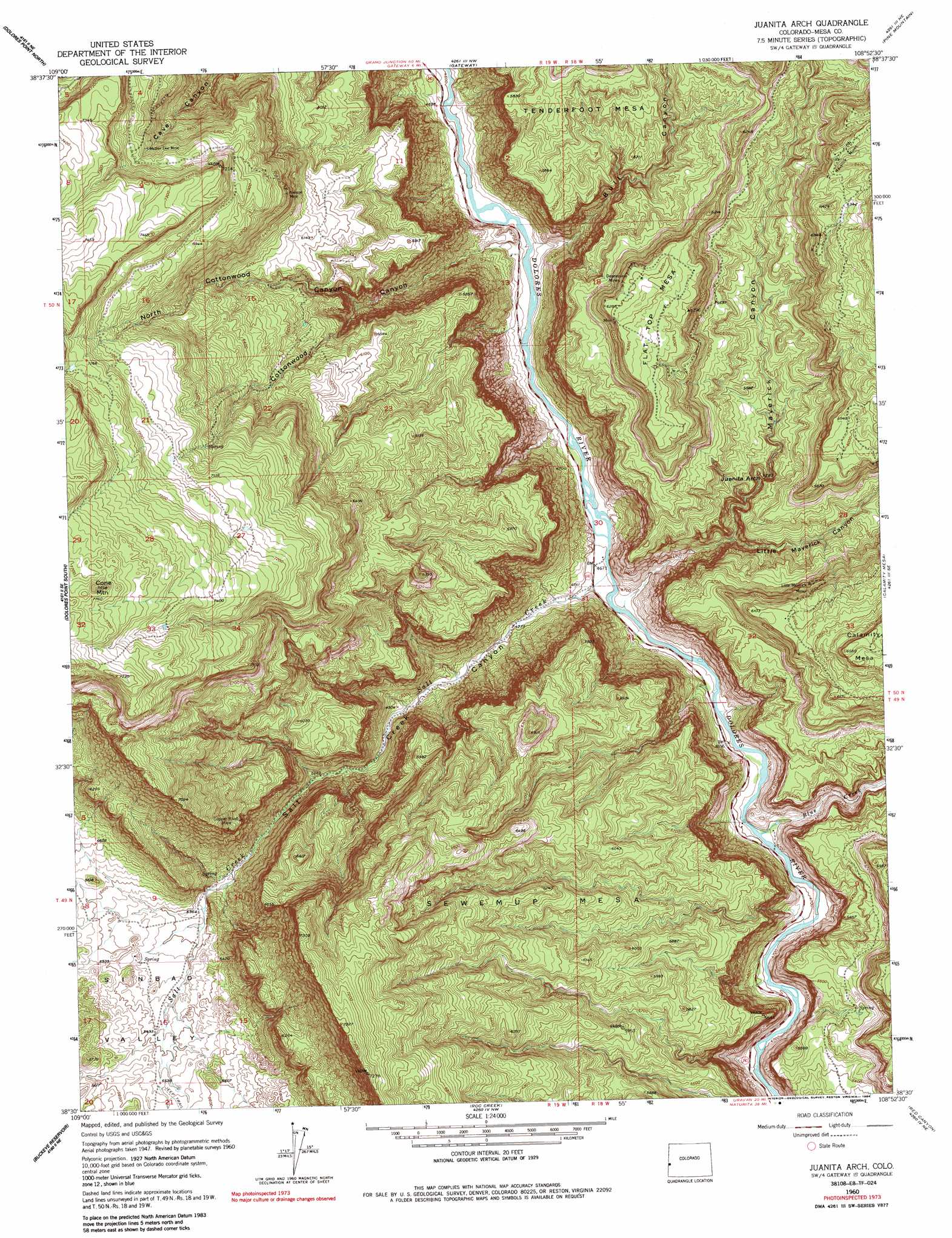
USGS Topo Quad 38108e8 - 1:24,000 scale
| Topo Map Name: | Juanita Arch |
| USGS Topo Quad ID: | 38108e8 |
| Print Size: | ca. 21 1/4" wide x 27" high |
| Southeast Coordinates: | 38.5° N latitude / 108.875° W longitude |
| Map Center Coordinates: | 38.5625° N latitude / 108.9375° W longitude |
| U.S. State: | CO |
| Filename: | o38108e8.jpg |
| Download Map JPG Image: | Juanita Arch topo map 1:24,000 scale |
| Map Type: | Topographic |
| Topo Series: | 7.5´ |
| Map Scale: | 1:24,000 |
| Source of Map Images: | United States Geological Survey (USGS) |
| Alternate Map Versions: |
Juanita Arch CO 1949, updated 1955 Download PDF Buy paper map Juanita Arch CO 1950 Download PDF Buy paper map Juanita Arch CO 1950, updated 1954 Download PDF Buy paper map Juanita Arch CO 1960, updated 1961 Download PDF Buy paper map Juanita Arch CO 1960, updated 1964 Download PDF Buy paper map Juanita Arch CO 1960, updated 1964 Download PDF Buy paper map Juanita Arch CO 1960, updated 1968 Download PDF Buy paper map Juanita Arch CO 1960, updated 1968 Download PDF Buy paper map Juanita Arch CO 1960, updated 1984 Download PDF Buy paper map Juanita Arch CO 2010 Download PDF Buy paper map Juanita Arch CO 2013 Download PDF Buy paper map Juanita Arch CO 2016 Download PDF Buy paper map |
1:24,000 Topo Quads surrounding Juanita Arch
Blue Chief Mesa |
Steamboat Mesa |
Two V Basin |
Fish Creek |
Snyder Flats |
Fisher Valley |
Dolores Point North |
Gateway |
Pine Mountain |
Casto Reservoir |
Mount Waas |
Dolores Point South |
Juanita Arch |
Calamity Mesa |
Uncompahgre Butte |
Mount Peale |
Buckeye Reservoir |
Roc Creek |
Red Canyon |
Atkinson Creek |
La Sal East |
Wray Mesa |
Paradox |
Davis Mesa |
Uravan |
> Back to 38108e1 at 1:100,000 scale
> Back to 38108a1 at 1:250,000 scale
> Back to U.S. Topo Maps home
Juanita Arch topo map: Gazetteer
Juanita Arch: Arches
Juanita Arch elevation 1586m 5203′Juanita Arch: Basins
Sinbad Valley elevation 1718m 5636′Juanita Arch: Mines
Big Indian Lease Mine elevation 1768m 5800′Copper Rivet Mine elevation 1898m 6227′
Depression Mine elevation 1921m 6302′
Depression Mines elevation 1885m 6184′
Kanarado Mine elevation 1984m 6509′
Little Maverick Mines elevation 1775m 5823′
Locust Mine elevation 1663m 5456′
Maverick Mines elevation 1960m 6430′
Mother Dee Mine elevation 2087m 6847′
Nielson Mine elevation 2029m 6656′
Wasp Mine elevation 1921m 6302′
Juanita Arch: Streams
Blue Creek elevation 1428m 4685′Salt Creek elevation 1418m 4652′
Juanita Arch: Summits
Cone Mountain elevation 2402m 7880′Flat Top Mesa elevation 1934m 6345′
Juanita Arch: Valleys
Blue Creek Canyon elevation 1428m 4685′Bull Canyon elevation 1409m 4622′
Cottonwood Canyon elevation 1418m 4652′
Little Maverick Canyon elevation 1493m 4898′
Maverick Canyon elevation 1422m 4665′
North Cottonwood Canyon elevation 1609m 5278′
Salt Creek Canyon elevation 1428m 4685′
Juanita Arch digital topo map on disk
Buy this Juanita Arch topo map showing relief, roads, GPS coordinates and other geographical features, as a high-resolution digital map file on DVD: