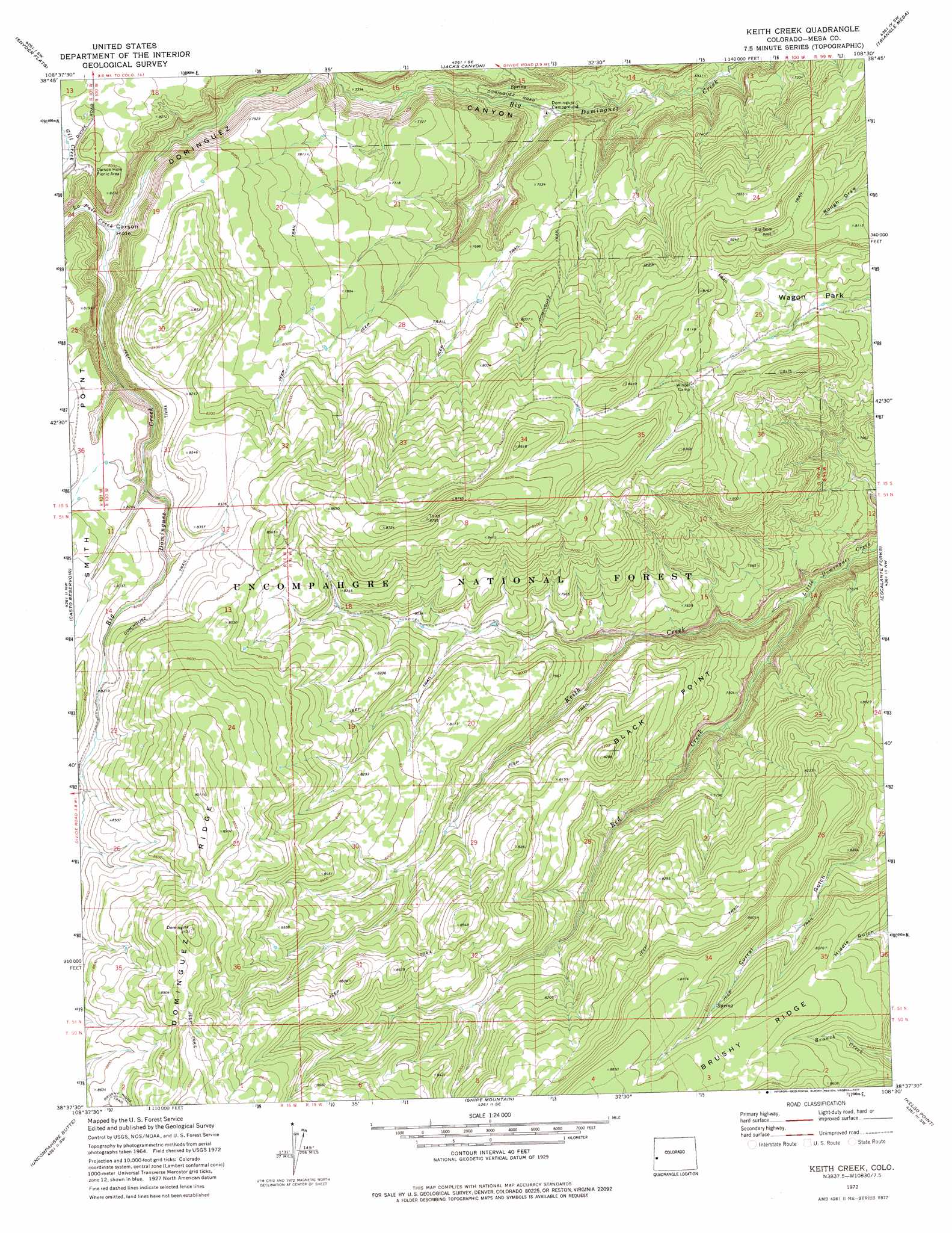
Keith Creek Topo Map Colorado
To zoom in, hover over the map of Keith Creek
USGS Topo Quad 38108f5 - 1:24,000 scale
| Topo Map Name: | Keith Creek |
| USGS Topo Quad ID: | 38108f5 |
| Print Size: | ca. 21 1/4" wide x 27" high |
| Southeast Coordinates: | 38.625° N latitude / 108.5° W longitude |
| Map Center Coordinates: | 38.6875° N latitude / 108.5625° W longitude |
| U.S. State: | CO |
| Filename: | o38108f5.jpg |
| Download Map JPG Image: | Keith Creek topo map 1:24,000 scale |
| Map Type: | Topographic |
| Topo Series: | 7.5´ |
| Map Scale: | 1:24,000 |
| Source of Map Images: | United States Geological Survey (USGS) |
| Alternate Map Versions: |
Keith Creek CO 1972, updated 1977 Download PDF Buy paper map Keith Creek CO 2011 Download PDF Buy paper map Keith Creek CO 2013 Download PDF Buy paper map Keith Creek CO 2016 Download PDF Buy paper map |
| FStopo: | US Forest Service topo Keith Creek is available: Download FStopo PDF Download FStopo TIF |
1:24,000 Topo Quads surrounding Keith Creek
Payne Wash |
Glade Park |
Island Mesa |
Whitewater |
Juniata Reservoir |
Fish Creek |
Snyder Flats |
Jacks Canyon |
Triangle Mesa |
Dominguez |
Pine Mountain |
Casto Reservoir |
Keith Creek |
Escalante Forks |
Good Point |
Calamity Mesa |
Uncompahgre Butte |
Snipe Mountain |
Kelso Point |
Cottonwood Basin |
Red Canyon |
Atkinson Creek |
Windy Point |
Starvation Point |
Moore Mesa |
> Back to 38108e1 at 1:100,000 scale
> Back to 38108a1 at 1:250,000 scale
> Back to U.S. Topo Maps home
Keith Creek topo map: Gazetteer
Keith Creek: Cliffs
Black Point elevation 2411m 7910′Keith Creek: Flats
Wagon Park elevation 2348m 7703′Keith Creek: Ridges
Brushy Ridge elevation 2650m 8694′Dominguez Ridge elevation 2748m 9015′
Keith Creek: Streams
Keith Creek elevation 2113m 6932′La Fair Creek elevation 2338m 7670′
Red Creek elevation 2113m 6932′
Keith Creek: Summits
Middle Mesa elevation 2514m 8248′Keith Creek: Trails
Dominguez Trail elevation 2510m 8234′Keith Creek: Valleys
Carson Hole elevation 2341m 7680′Keith Creek digital topo map on disk
Buy this Keith Creek topo map showing relief, roads, GPS coordinates and other geographical features, as a high-resolution digital map file on DVD: