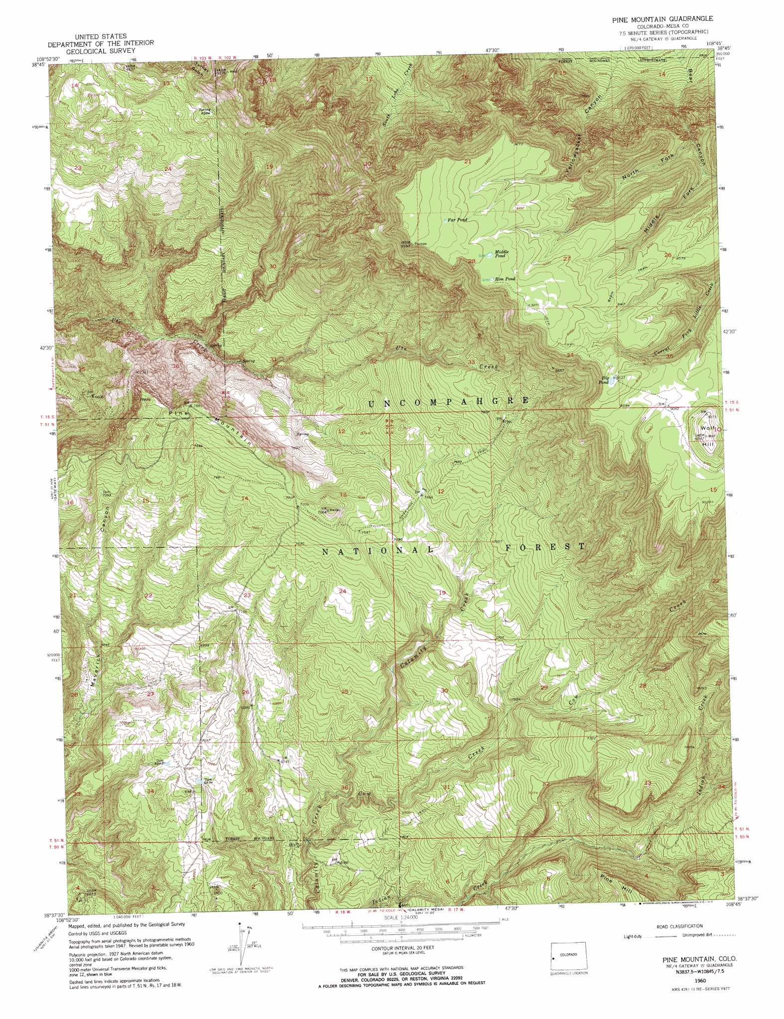
Pine Mountain Topo Map Colorado
To zoom in, hover over the map of Pine Mountain
USGS Topo Quad 38108f7 - 1:24,000 scale
| Topo Map Name: | Pine Mountain |
| USGS Topo Quad ID: | 38108f7 |
| Print Size: | ca. 21 1/4" wide x 27" high |
| Southeast Coordinates: | 38.625° N latitude / 108.75° W longitude |
| Map Center Coordinates: | 38.6875° N latitude / 108.8125° W longitude |
| U.S. State: | CO |
| Filename: | o38108f7.jpg |
| Download Map JPG Image: | Pine Mountain topo map 1:24,000 scale |
| Map Type: | Topographic |
| Topo Series: | 7.5´ |
| Map Scale: | 1:24,000 |
| Source of Map Images: | United States Geological Survey (USGS) |
| Alternate Map Versions: |
Pine Mountain CO 1950 Download PDF Buy paper map Pine Mountain CO 1960, updated 1961 Download PDF Buy paper map Pine Mountain CO 1960, updated 1961 Download PDF Buy paper map Pine Mountain CO 1960, updated 1969 Download PDF Buy paper map Pine Mountain CO 2011 Download PDF Buy paper map Pine Mountain CO 2013 Download PDF Buy paper map Pine Mountain CO 2016 Download PDF Buy paper map |
| FStopo: | US Forest Service topo Pine Mountain is available: Download FStopo PDF Download FStopo TIF |
1:24,000 Topo Quads surrounding Pine Mountain
Marble Canyon |
Bieser Creek |
Payne Wash |
Glade Park |
Island Mesa |
Steamboat Mesa |
Two V Basin |
Fish Creek |
Snyder Flats |
Jacks Canyon |
Dolores Point North |
Gateway |
Pine Mountain |
Casto Reservoir |
Keith Creek |
Dolores Point South |
Juanita Arch |
Calamity Mesa |
Uncompahgre Butte |
Snipe Mountain |
Buckeye Reservoir |
Roc Creek |
Red Canyon |
Atkinson Creek |
Windy Point |
> Back to 38108e1 at 1:100,000 scale
> Back to 38108a1 at 1:250,000 scale
> Back to U.S. Topo Maps home
Pine Mountain topo map: Gazetteer
Pine Mountain: Lakes
Big Pond elevation 2785m 9137′Far Pond elevation 2852m 9356′
Middle Pond elevation 2834m 9297′
Rim Pond elevation 2831m 9288′
Pine Mountain: Mines
Maverick Mine elevation 2013m 6604′Yellow Jacket Mine elevation 2013m 6604′
Pine Mountain: Streams
Cow Creek elevation 1967m 6453′Pine Mountain: Summits
Pine Mountain elevation 2412m 7913′Wolf Hill elevation 2818m 9245′
Pine Mountain: Trails
Snowshoe Trail elevation 2319m 7608′Pine Mountain: Valleys
Jefferson Canyon elevation 2085m 6840′Middle Fork Bear Canyon elevation 2565m 8415′
North Fork Bear Canyon elevation 2504m 8215′
Yellowjacket Canyon elevation 2068m 6784′
Pine Mountain digital topo map on disk
Buy this Pine Mountain topo map showing relief, roads, GPS coordinates and other geographical features, as a high-resolution digital map file on DVD: