Gateway Topo Map Colorado
To zoom in, hover over the map of Gateway
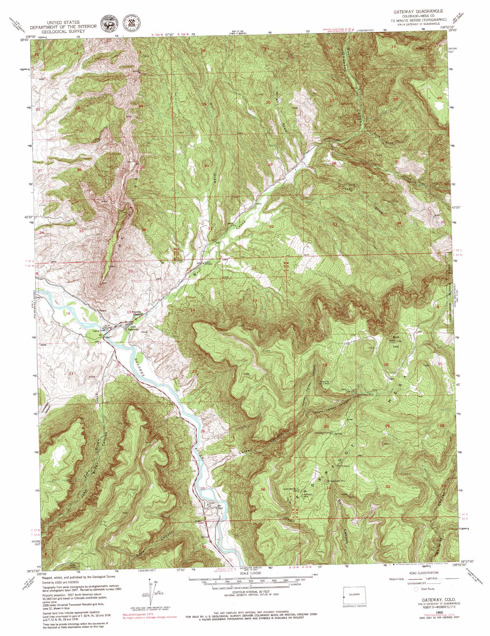
USGS Topo Quad 38108f8 - 1:24,000 scale
| Topo Map Name: | Gateway |
| USGS Topo Quad ID: | 38108f8 |
| Print Size: | ca. 21 1/4" wide x 27" high |
| Southeast Coordinates: | 38.625° N latitude / 108.875° W longitude |
| Map Center Coordinates: | 38.6875° N latitude / 108.9375° W longitude |
| U.S. State: | CO |
| Filename: | o38108f8.jpg |
| Download Map JPG Image: | Gateway topo map 1:24,000 scale |
| Map Type: | Topographic |
| Topo Series: | 7.5´ |
| Map Scale: | 1:24,000 |
| Source of Map Images: | United States Geological Survey (USGS) |
| Alternate Map Versions: |
Gateway CO 1949, updated 1957 Download PDF Buy paper map Gateway CO 1949, updated 1957 Download PDF Buy paper map Gateway CO 1952 Download PDF Buy paper map Gateway CO 1952 Download PDF Buy paper map Gateway CO 1960, updated 1961 Download PDF Buy paper map Gateway CO 1960, updated 1961 Download PDF Buy paper map Gateway CO 1960, updated 1966 Download PDF Buy paper map Gateway CO 1960, updated 1979 Download PDF Buy paper map Gateway CO 2011 Download PDF Buy paper map Gateway CO 2013 Download PDF Buy paper map Gateway CO 2016 Download PDF Buy paper map |
| FStopo: | US Forest Service topo Gateway is available: Download FStopo PDF Download FStopo TIF |
1:24,000 Topo Quads surrounding Gateway
Big Triangle |
Marble Canyon |
Bieser Creek |
Payne Wash |
Glade Park |
Blue Chief Mesa |
Steamboat Mesa |
Two V Basin |
Fish Creek |
Snyder Flats |
Fisher Valley |
Dolores Point North |
Gateway |
Pine Mountain |
Casto Reservoir |
Mount Waas |
Dolores Point South |
Juanita Arch |
Calamity Mesa |
Uncompahgre Butte |
Mount Peale |
Buckeye Reservoir |
Roc Creek |
Red Canyon |
Atkinson Creek |
> Back to 38108e1 at 1:100,000 scale
> Back to 38108a1 at 1:250,000 scale
> Back to U.S. Topo Maps home
Gateway topo map: Gazetteer
Gateway: Airports
Hubbard Airport elevation 1388m 4553′Gateway: Arroyos
Castro Draw elevation 1506m 4940′Gateway: Cliffs
The Palisade elevation 2009m 6591′Gateway: Mines
Black Mama Number 3 Mine elevation 2103m 6899′Liberty Bell Number 2 Mine elevation 2031m 6663′
Mammoth Mine elevation 2044m 6706′
Protector Mine elevation 2036m 6679′
Rajah Group Mines elevation 1415m 4642′
Rena Mine elevation 2086m 6843′
Shelby Dean Two Mine elevation 1936m 6351′
Tenderfoot Group Mine elevation 2149m 7050′
Vanadium King Mine elevation 2086m 6843′
Vanaking Number 1 Mine elevation 2111m 6925′
Gateway: Populated Places
Gateway elevation 1406m 4612′Gateway: Streams
Birch Creek elevation 1569m 5147′John Brown Creek elevation 1388m 4553′
Ute Creek elevation 1546m 5072′
West Creek elevation 1388m 4553′
Gateway: Summits
Bull Hill elevation 2352m 7716′Tenderfoot Mesa elevation 2352m 7716′
Gateway: Valleys
Bull Draw elevation 1451m 4760′Castro Draw elevation 1506m 4940′
Cave Canyon elevation 1403m 4603′
John Brown Canyon elevation 1392m 4566′
Larsen Canyon elevation 1402m 4599′
Lumsden Canyon elevation 1394m 4573′
North Larsen Canyon elevation 1827m 5994′
South Larsen Canyon elevation 1827m 5994′
Wright Draw elevation 1506m 4940′
Gateway digital topo map on disk
Buy this Gateway topo map showing relief, roads, GPS coordinates and other geographical features, as a high-resolution digital map file on DVD: