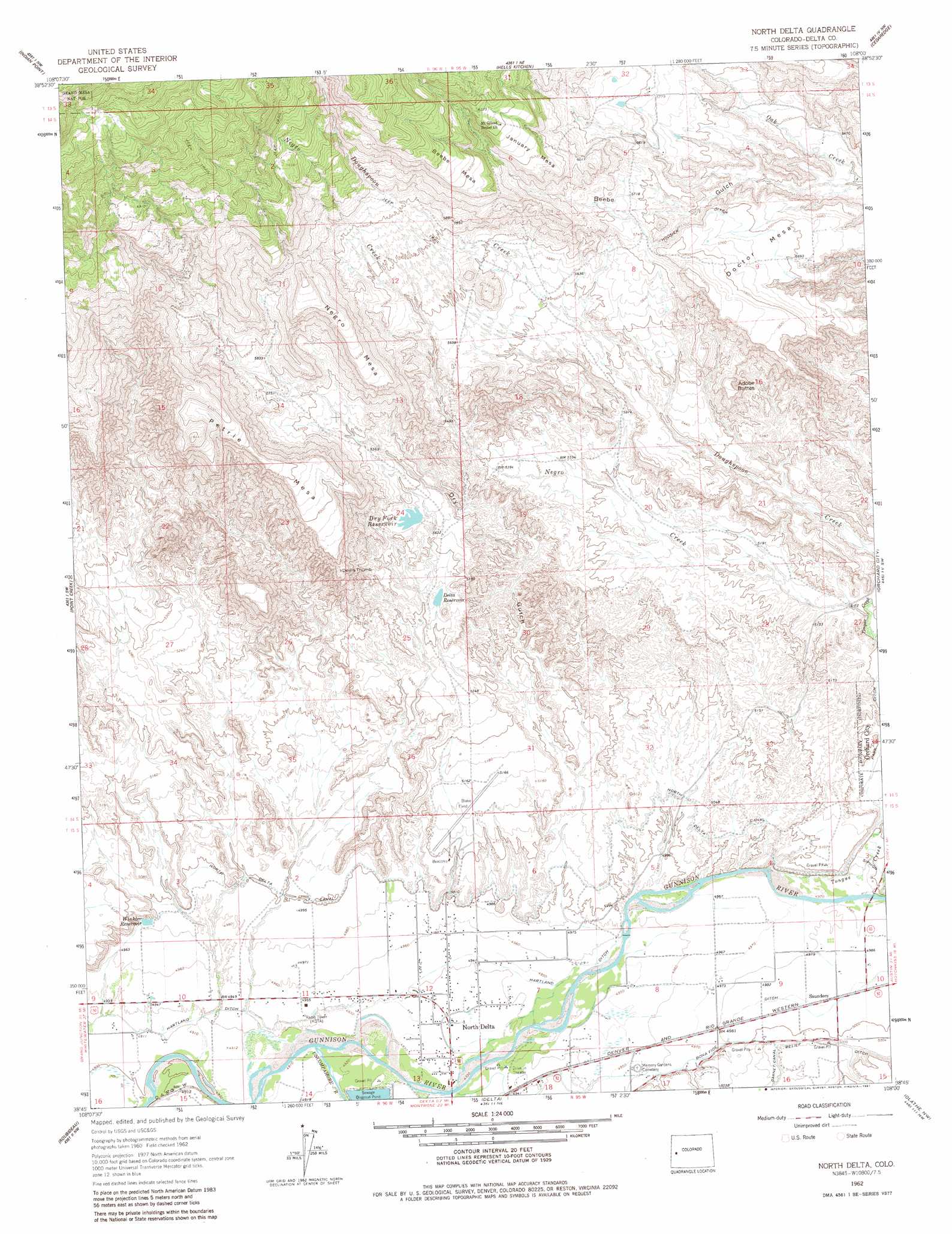
North Delta Topo Map Colorado
To zoom in, hover over the map of North Delta
USGS Topo Quad 38108g1 - 1:24,000 scale
| Topo Map Name: | North Delta |
| USGS Topo Quad ID: | 38108g1 |
| Print Size: | ca. 21 1/4" wide x 27" high |
| Southeast Coordinates: | 38.75° N latitude / 108° W longitude |
| Map Center Coordinates: | 38.8125° N latitude / 108.0625° W longitude |
| U.S. State: | CO |
| Filename: | o38108g1.jpg |
| Download Map JPG Image: | North Delta topo map 1:24,000 scale |
| Map Type: | Topographic |
| Topo Series: | 7.5´ |
| Map Scale: | 1:24,000 |
| Source of Map Images: | United States Geological Survey (USGS) |
| Alternate Map Versions: |
North Delta CO 1962, updated 1966 Download PDF Buy paper map North Delta CO 1962, updated 1966 Download PDF Buy paper map North Delta CO 1962, updated 1981 Download PDF Buy paper map North Delta CO 2011 Download PDF Buy paper map North Delta CO 2013 Download PDF Buy paper map North Delta CO 2016 Download PDF Buy paper map |
| FStopo: | US Forest Service topo North Delta is available: Download FStopo PDF Download FStopo TIF |
1:24,000 Topo Quads surrounding North Delta
Palisade |
Lands End |
Mesa Lakes |
Grand Mesa |
Leon Peak |
Juniata Reservoir |
Indian Point |
Hells Kitchen |
Cedaredge |
Dry Creek |
Dominguez |
Point Creek |
North Delta |
Orchard City |
Lazear |
Good Point |
Roubideau |
Delta |
Olathe Nw |
Black Ridge |
Cottonwood Basin |
Camel Back |
Hoovers Corner |
Olathe |
Red Rock Canyon |
> Back to 38108e1 at 1:100,000 scale
> Back to 38108a1 at 1:250,000 scale
> Back to U.S. Topo Maps home
North Delta topo map: Gazetteer
North Delta: Airports
Blake Field elevation 1562m 5124′North Delta: Canals
Hartland Ditch elevation 1507m 4944′Hoosier Ditch elevation 1753m 5751′
North Delta Canal elevation 1526m 5006′
Park Ditch elevation 1544m 5065′
Relief Ditch elevation 1530m 5019′
North Delta: Dams
Delta Control Dam elevation 1629m 5344′Lewis Dam elevation 1650m 5413′
North Delta: Pillars
Devils Thumb elevation 1754m 5754′North Delta: Populated Places
North Delta elevation 1505m 4937′Saunders elevation 1522m 4993′
North Delta: Reservoirs
Delta Control Reservoir elevation 1629m 5344′Delta Reservoir elevation 1629m 5344′
Dry Fork Reservoir elevation 1665m 5462′
Lewis Reservoir elevation 1650m 5413′
Winkler Reservoir elevation 1525m 5003′
North Delta: Streams
Negro Creek elevation 1563m 5127′Tongue Creek elevation 1512m 4960′
Uncompahgre River elevation 1498m 4914′
North Delta: Summits
Adobe Buttes elevation 1698m 5570′Beebe Mesa elevation 1986m 6515′
Doctor Mesa elevation 1807m 5928′
January Mesa elevation 1923m 6309′
Negro Mesa elevation 1931m 6335′
Petrie Mesa elevation 1956m 6417′
North Delta: Valleys
Dry Gulch elevation 1516m 4973′North Delta digital topo map on disk
Buy this North Delta topo map showing relief, roads, GPS coordinates and other geographical features, as a high-resolution digital map file on DVD: