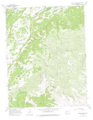
Hells Kitchen Topo Map Colorado
To zoom in, hover over the map of Hells Kitchen
USGS Topo Quad 38108h1 - 1:24,000 scale
| Topo Map Name: | Hells Kitchen |
| USGS Topo Quad ID: | 38108h1 |
| Print Size: | ca. 21 1/4" wide x 27" high |
| Southeast Coordinates: | 38.875° N latitude / 108° W longitude |
| Map Center Coordinates: | 38.9375° N latitude / 108.0625° W longitude |
| U.S. State: | CO |
| Filename: | o38108h1.jpg |
| Download Map JPG Image: | Hells Kitchen topo map 1:24,000 scale |
| Map Type: | Topographic |
| Topo Series: | 7.5´ |
| Map Scale: | 1:24,000 |
| Source of Map Images: | United States Geological Survey (USGS) |
| Alternate Map Versions: |
Hells Kitchen CO 1965, updated 1968 Download PDF Buy paper map Hells Kitchen CO 1965, updated 1968 Download PDF Buy paper map Hells Kitchen CO 1965, updated 1975 Download PDF Buy paper map Hells Kitchen CO 2011 Download PDF Buy paper map Hells Kitchen CO 2013 Download PDF Buy paper map Hells Kitchen CO 2016 Download PDF Buy paper map |
| FStopo: | US Forest Service topo Hells Kitchen is available: Download FStopo PDF Download FStopo TIF |
1:24,000 Topo Quads surrounding Hells Kitchen
> Back to 38108e1 at 1:100,000 scale
> Back to 38108a1 at 1:250,000 scale
> Back to U.S. Topo Maps home
Hells Kitchen topo map: Gazetteer
Hells Kitchen: Canals
Cedar Park Ditch elevation 1906m 6253′Dirty George Creek and Doughspoon Aqueduct elevation 2209m 7247′
Dirty George Creek Aqueduct elevation 2508m 8228′
Doughspoon Aqueduct elevation 2666m 8746′
Eagle Ditch elevation 2147m 7043′
Granby Ditch elevation 2480m 8136′
Hoosier Ditch elevation 2371m 7778′
Sanburg Ditch elevation 1931m 6335′
Hells Kitchen: Dams
Big Battlement Dam elevation 3070m 10072′Clark Dam elevation 2611m 8566′
Delta Number 3 Dam elevation 2761m 9058′
Dugger Dam elevation 2815m 9235′
Flowing Park Dam elevation 3065m 10055′
Granby Number 11 Dam elevation 3048m 10000′
Granby Number 12 Dam elevation 3040m 9973′
Granby Number 6 Dam elevation 3035m 9957′
Granby Number 7 Dam elevation 3016m 9895′
Granby Number 9 Dam elevation 3058m 10032′
Hogchute Dam elevation 2999m 9839′
Little Battlement Dam elevation 3064m 10052′
Pitcairne Number 1 Dam elevation 2868m 9409′
Porter Number 1 Dam elevation 2793m 9163′
Porter Number 4 Dam elevation 2858m 9376′
Hells Kitchen: Flats
Flowing Park elevation 3072m 10078′Hells Kitchen: Lakes
Clear Lake elevation 3123m 10246′Crane Lake elevation 3094m 10150′
Greenwood Lake elevation 3106m 10190′
Hells Kitchen: Mines
Fairview Mine elevation 2085m 6840′Rollins Mine elevation 2260m 7414′
Tomahawk Mine elevation 1923m 6309′
Hells Kitchen: Reservoirs
Big Battlement Lake elevation 3071m 10075′Carson Lake elevation 3012m 9881′
Clara Reservoir elevation 2598m 8523′
Clark Reservoir elevation 2598m 8523′
Delta Reservoir elevation 2778m 9114′
Delta Reservoir Number 3 elevation 2761m 9058′
Dugger Reservoir elevation 2815m 9235′
Flowing Park Reservoir elevation 3065m 10055′
Granby Number 11 Reservoir elevation 3048m 10000′
Granby Reservoir Number 11 elevation 3052m 10013′
Granby Reservoir Number 12 elevation 3040m 9973′
Granby Reservoir Number 6 elevation 3035m 9957′
Granby Reservoir Number 7 elevation 3016m 9895′
Granby Reservoir Number 9 elevation 3058m 10032′
Hogchute Reservoir elevation 2999m 9839′
Little Battlement Lake elevation 3064m 10052′
Morris Reservoir elevation 2799m 9183′
Pitcairne Reservoir elevation 2868m 9409′
Porter Number 1 Reservoir elevation 2793m 9163′
Porter Reservoir Number 4 elevation 2858m 9376′
Porter Reservoir Number One elevation 2778m 9114′
Hells Kitchen: Streams
Camp Creek elevation 1848m 6062′East Fork Doughspoon Creek elevation 1991m 6532′
Sand Creek elevation 1872m 6141′
West Fork Doughspoon Creek elevation 1991m 6532′
Hells Kitchen: Trails
Blue Grouse Trail elevation 2607m 8553′Bull and Brown Trail elevation 2961m 9714′
Carson Lake Trail elevation 3068m 10065′
Point Camp Trail elevation 2777m 9110′
Point Trail elevation 2960m 9711′
Hells Kitchen: Valleys
Hells Kitchen elevation 2271m 7450′Hells Kitchen digital topo map on disk
Buy this Hells Kitchen topo map showing relief, roads, GPS coordinates and other geographical features, as a high-resolution digital map file on DVD:


