Juniata Reservoir Topo Map Colorado
To zoom in, hover over the map of Juniata Reservoir
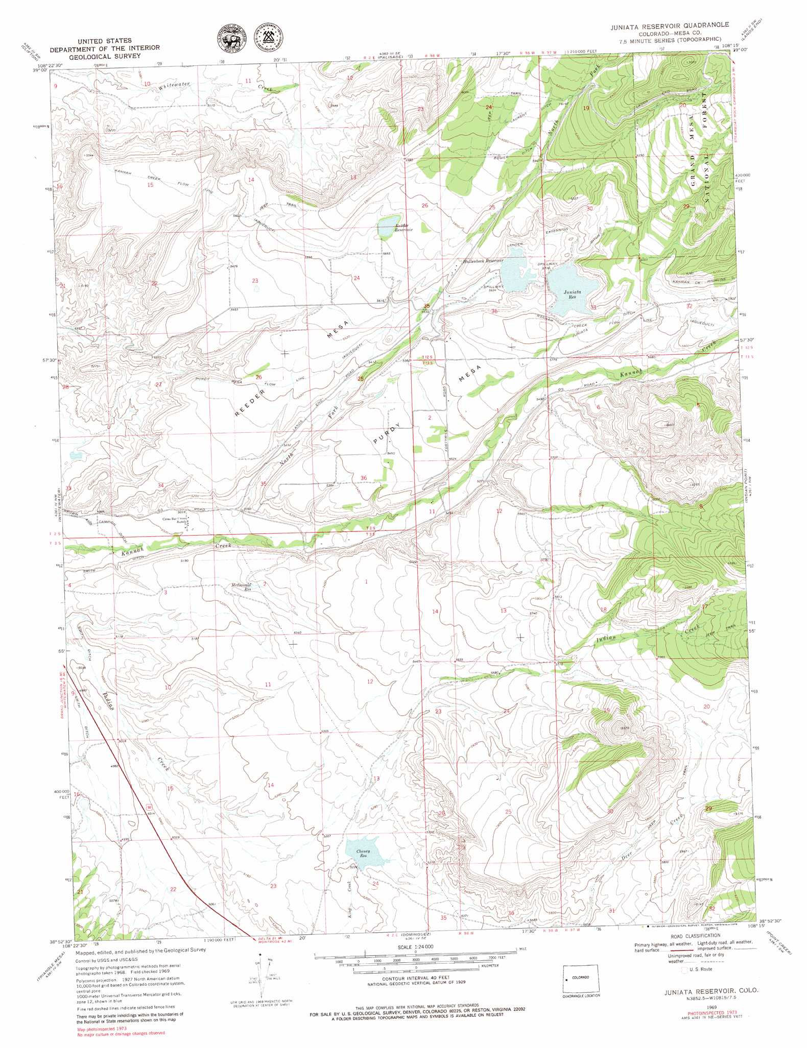
USGS Topo Quad 38108h3 - 1:24,000 scale
| Topo Map Name: | Juniata Reservoir |
| USGS Topo Quad ID: | 38108h3 |
| Print Size: | ca. 21 1/4" wide x 27" high |
| Southeast Coordinates: | 38.875° N latitude / 108.25° W longitude |
| Map Center Coordinates: | 38.9375° N latitude / 108.3125° W longitude |
| U.S. State: | CO |
| Filename: | o38108h3.jpg |
| Download Map JPG Image: | Juniata Reservoir topo map 1:24,000 scale |
| Map Type: | Topographic |
| Topo Series: | 7.5´ |
| Map Scale: | 1:24,000 |
| Source of Map Images: | United States Geological Survey (USGS) |
| Alternate Map Versions: |
Juniata Reservoir CO 1969, updated 1972 Download PDF Buy paper map Juniata Reservoir CO 1969, updated 1972 Download PDF Buy paper map Juniata Reservoir CO 1969, updated 1979 Download PDF Buy paper map Juniata Reservoir CO 2011 Download PDF Buy paper map Juniata Reservoir CO 2013 Download PDF Buy paper map Juniata Reservoir CO 2016 Download PDF Buy paper map |
| FStopo: | US Forest Service topo Juniata Reservoir is available: Download FStopo PDF Download FStopo TIF |
1:24,000 Topo Quads surrounding Juniata Reservoir
Corcoran Point |
Round Mountain |
Cameo |
Mesa |
Molina |
Grand Junction |
Clifton |
Palisade |
Lands End |
Mesa Lakes |
Island Mesa |
Whitewater |
Juniata Reservoir |
Indian Point |
Hells Kitchen |
Jacks Canyon |
Triangle Mesa |
Dominguez |
Point Creek |
North Delta |
Keith Creek |
Escalante Forks |
Good Point |
Roubideau |
Delta |
> Back to 38108e1 at 1:100,000 scale
> Back to 38108a1 at 1:250,000 scale
> Back to U.S. Topo Maps home
Juniata Reservoir topo map: Gazetteer
Juniata Reservoir: Canals
Bower Ditch elevation 1823m 5980′Kannah Creek Flow Line elevation 1672m 5485′
Kannah Creek Highline Ditch elevation 1840m 6036′
Lander Extension Ditch elevation 1710m 5610′
Laurent Ditch elevation 1854m 6082′
Purdy Mesa Flow Line elevation 1635m 5364′
Juniata Reservoir: Dams
Cheney Dam elevation 1587m 5206′Hallenbeck Number 1 Dam elevation 1709m 5606′
Juniata Dam elevation 1743m 5718′
Reeder Dam elevation 1732m 5682′
Juniata Reservoir: Reservoirs
Cheney Reservoir elevation 1586m 5203′Hallenbeck Reservoir elevation 1708m 5603′
Hallenbeck Reservoir Number 1 elevation 1709m 5606′
Juniata Reservoir elevation 1743m 5718′
McDonald Reservoir elevation 1606m 5269′
Reeder Reservoir elevation 1732m 5682′
Juniata Reservoir: Streams
Juniata Ditch elevation 1703m 5587′North Fork Kannah Creek elevation 1537m 5042′
Juniata Reservoir digital topo map on disk
Buy this Juniata Reservoir topo map showing relief, roads, GPS coordinates and other geographical features, as a high-resolution digital map file on DVD: