Bieser Creek Topo Map Colorado
To zoom in, hover over the map of Bieser Creek
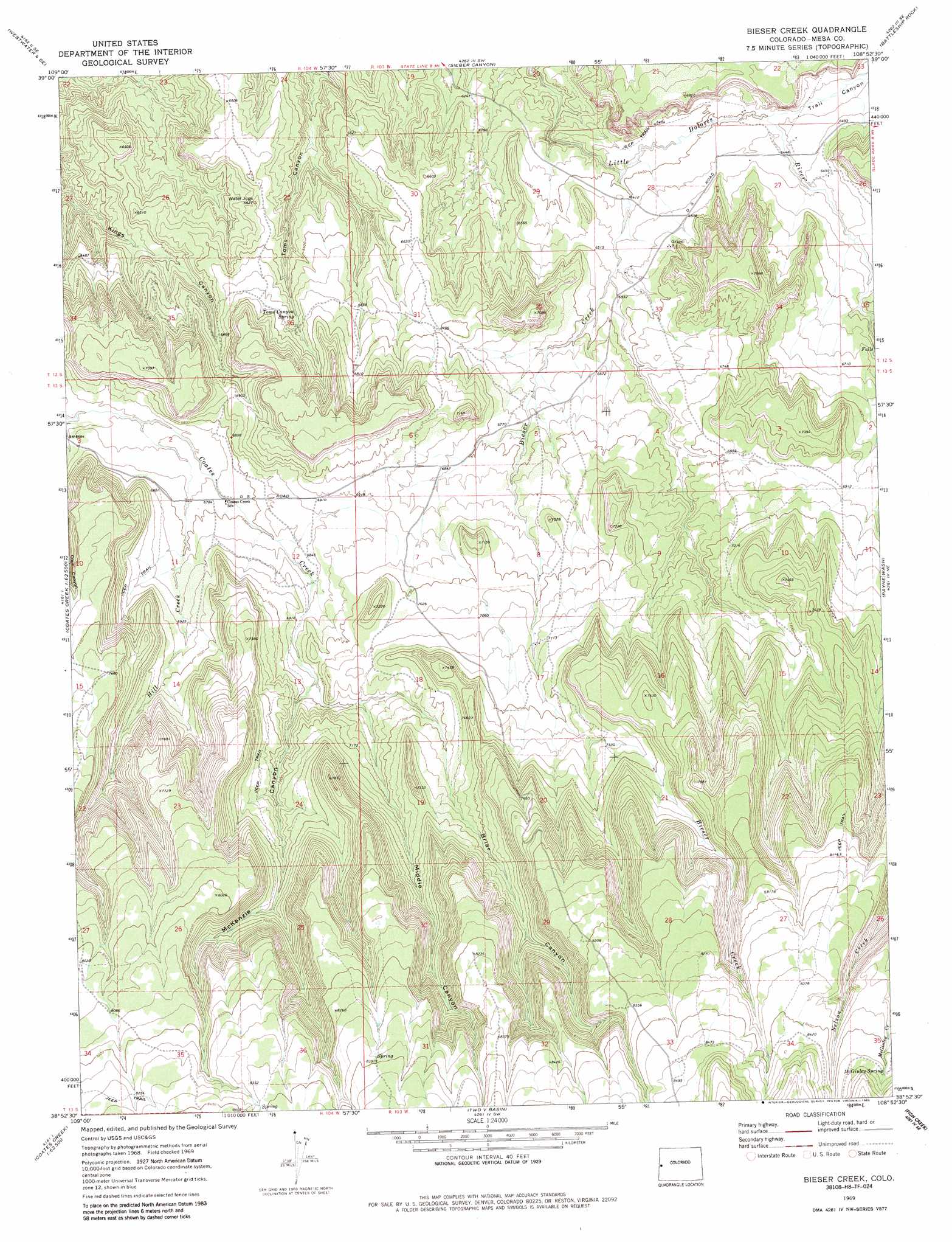
USGS Topo Quad 38108h8 - 1:24,000 scale
| Topo Map Name: | Bieser Creek |
| USGS Topo Quad ID: | 38108h8 |
| Print Size: | ca. 21 1/4" wide x 27" high |
| Southeast Coordinates: | 38.875° N latitude / 108.875° W longitude |
| Map Center Coordinates: | 38.9375° N latitude / 108.9375° W longitude |
| U.S. State: | CO |
| Filename: | o38108h8.jpg |
| Download Map JPG Image: | Bieser Creek topo map 1:24,000 scale |
| Map Type: | Topographic |
| Topo Series: | 7.5´ |
| Map Scale: | 1:24,000 |
| Source of Map Images: | United States Geological Survey (USGS) |
| Alternate Map Versions: |
Bieser Creek CO 1969, updated 1973 Download PDF Buy paper map Bieser Creek CO 1969, updated 1985 Download PDF Buy paper map Bieser Creek CO 2010 Download PDF Buy paper map Bieser Creek CO 2013 Download PDF Buy paper map Bieser Creek CO 2016 Download PDF Buy paper map |
1:24,000 Topo Quads surrounding Bieser Creek
Harley Dome |
Bitter Creek Well |
Ruby Canyon |
Mack |
Fruita |
Agate |
Westwater |
Sieber Canyon |
Battleship Rock |
Colorado National Monument |
Big Triangle |
Marble Canyon |
Bieser Creek |
Payne Wash |
Glade Park |
Blue Chief Mesa |
Steamboat Mesa |
Two V Basin |
Fish Creek |
Snyder Flats |
Fisher Valley |
Dolores Point North |
Gateway |
Pine Mountain |
Casto Reservoir |
> Back to 38108e1 at 1:100,000 scale
> Back to 38108a1 at 1:250,000 scale
> Back to U.S. Topo Maps home
Bieser Creek topo map: Gazetteer
Bieser Creek: Springs
McGinley Spring elevation 2572m 8438′Toms Canyon Spring elevation 2029m 6656′
Bieser Creek: Streams
Bieser Creek elevation 1939m 6361′Hill Creek elevation 2037m 6683′
Trail Canyon elevation 1960m 6430′
Trail Canyon Wash elevation 1952m 6404′
Wilderness Creek elevation 1984m 6509′
Bieser Creek: Valleys
Briar Canyon elevation 2144m 7034′McKenzie Canyon elevation 2099m 6886′
Middle Canyon elevation 2147m 7043′
Bieser Creek digital topo map on disk
Buy this Bieser Creek topo map showing relief, roads, GPS coordinates and other geographical features, as a high-resolution digital map file on DVD: