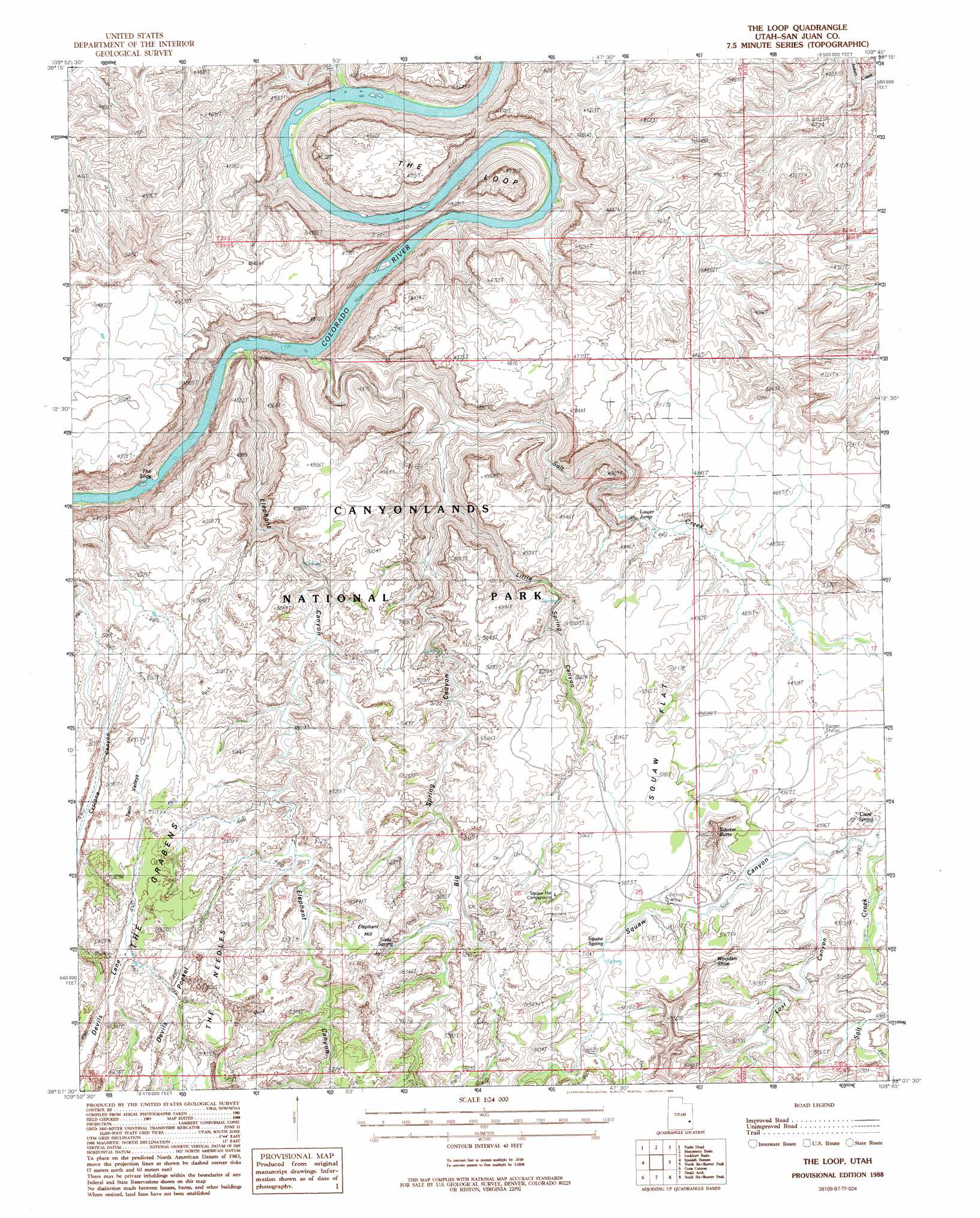
The Loop Topo Map Utah
To zoom in, hover over the map of The Loop
USGS Topo Quad 38109b7 - 1:24,000 scale
| Topo Map Name: | The Loop |
| USGS Topo Quad ID: | 38109b7 |
| Print Size: | ca. 21 1/4" wide x 27" high |
| Southeast Coordinates: | 38.125° N latitude / 109.75° W longitude |
| Map Center Coordinates: | 38.1875° N latitude / 109.8125° W longitude |
| U.S. State: | UT |
| Filename: | o38109b7.jpg |
| Download Map JPG Image: | The Loop topo map 1:24,000 scale |
| Map Type: | Topographic |
| Topo Series: | 7.5´ |
| Map Scale: | 1:24,000 |
| Source of Map Images: | United States Geological Survey (USGS) |
| Alternate Map Versions: |
Carlisle 3 NE UT 1955, updated 1956 Download PDF Buy paper map The Loop UT 1988, updated 1988 Download PDF Buy paper map The Loop UT 1988, updated 1988 Download PDF Buy paper map The Loop UT 1997, updated 2002 Download PDF Buy paper map The Loop UT 2010 Download PDF Buy paper map The Loop UT 2014 Download PDF Buy paper map |
1:24,000 Topo Quads surrounding The Loop
Horsethief Canyon |
Upheaval Dome |
Musselman Arch |
Shafer Basin |
Trough Springs Canyon |
Cleopatras Chair |
Turks Head |
Monument Basin |
Lockhart Basin |
Eightmile Rock |
Elaterite Basin |
Spanish Bottom |
The Loop |
North Six-Shooter Peak |
Harts Point North |
Teapot Rock |
Cross Canyon |
Druid Arch |
South Six-Shooter Peak |
Harts Point South |
Bowdie Canyon East |
Fable Valley |
House Park Butte |
Cathedral Butte |
Shay Mountain |
> Back to 38109a1 at 1:100,000 scale
> Back to 38108a1 at 1:250,000 scale
> Back to U.S. Topo Maps home
The Loop topo map: Gazetteer
The Loop: Arches
Wooden Shoe elevation 1604m 5262′The Loop: Areas
Twin Valleys elevation 1538m 5045′The Loop: Basins
Cyclone Canyon elevation 1483m 4865′Devils Lane elevation 1582m 5190′
Devils Pocket elevation 1611m 5285′
Twin Valleys elevation 1524m 5000′
The Loop: Bends
The Loop elevation 1418m 4652′The Loop elevation 1415m 4642′
The Loop: Falls
Lower Jump elevation 1404m 4606′The Loop: Flats
Squaw Flat elevation 1537m 5042′The Loop: Slopes
The Slide elevation 1396m 4580′The Loop: Springs
Cave Spring elevation 1506m 4940′Soda Spring elevation 1569m 5147′
Soda Spring elevation 1573m 5160′
Squaw Spring elevation 1546m 5072′
The Loop: Streams
Salt Creek elevation 1185m 3887′The Loop: Summits
Elephant Hill elevation 1687m 5534′Squaw Butte elevation 1627m 5337′
The Loop: Trails
Cave Spring Trail elevation 1495m 4904′Silver Stairs elevation 1536m 5039′
The Loop: Valleys
Big Spring Canyon elevation 1260m 4133′Devils Canyon elevation 1533m 5029′
Devils Pocket elevation 1537m 5042′
Elephant Canyon elevation 1184m 3884′
Little Spring Canyon elevation 1297m 4255′
Little Spring Canyon elevation 1288m 4225′
Lost Canyon elevation 1499m 4917′
The Loop digital topo map on disk
Buy this The Loop topo map showing relief, roads, GPS coordinates and other geographical features, as a high-resolution digital map file on DVD: