Buckeye Reservoir Topo Map Utah
To zoom in, hover over the map of Buckeye Reservoir
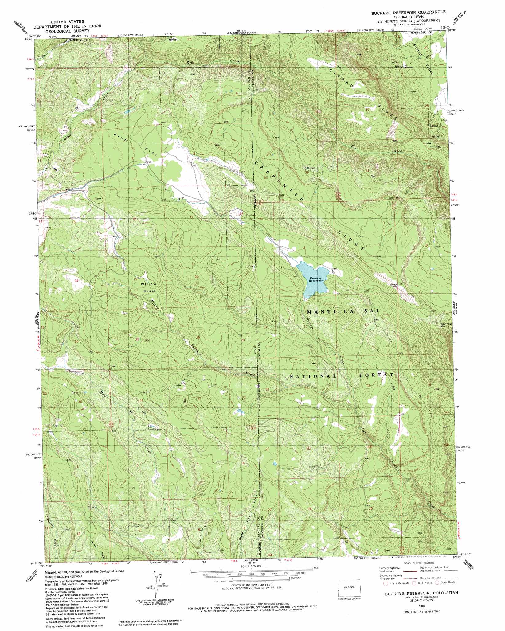
USGS Topo Quad 38109d1 - 1:24,000 scale
| Topo Map Name: | Buckeye Reservoir |
| USGS Topo Quad ID: | 38109d1 |
| Print Size: | ca. 21 1/4" wide x 27" high |
| Southeast Coordinates: | 38.375° N latitude / 109° W longitude |
| Map Center Coordinates: | 38.4375° N latitude / 109.0625° W longitude |
| U.S. States: | UT, CO |
| Filename: | o38109d1.jpg |
| Download Map JPG Image: | Buckeye Reservoir topo map 1:24,000 scale |
| Map Type: | Topographic |
| Topo Series: | 7.5´ |
| Map Scale: | 1:24,000 |
| Source of Map Images: | United States Geological Survey (USGS) |
| Alternate Map Versions: |
Mt Peale 1 NE CO 1954 Download PDF Buy paper map Buckeye Reservoir CO 1986, updated 1986 Download PDF Buy paper map Buckeye Reservoir CO 2001, updated 2004 Download PDF Buy paper map Buckeye Reservoir CO 2011 Download PDF Buy paper map Buckeye Reservoir CO 2013 Download PDF Buy paper map Buckeye Reservoir CO 2016 Download PDF Buy paper map |
| FStopo: | US Forest Service topo Buckeye Reservoir is available: Download FStopo PDF Download FStopo TIF |
1:24,000 Topo Quads surrounding Buckeye Reservoir
Fisher Towers |
Fisher Valley |
Dolores Point North |
Gateway |
Pine Mountain |
Warner Lake |
Mount Waas |
Dolores Point South |
Juanita Arch |
Calamity Mesa |
Mount Tukuhnikivatz |
Mount Peale |
Buckeye Reservoir |
Roc Creek |
Red Canyon |
La Sal West |
La Sal East |
Wray Mesa |
Paradox |
Davis Mesa |
Sandstone Draw |
Lisbon Valley |
Lisbon Gap |
Anderson Mesa |
Bull Canyon |
> Back to 38109a1 at 1:100,000 scale
> Back to 38108a1 at 1:250,000 scale
> Back to U.S. Topo Maps home
Buckeye Reservoir topo map: Gazetteer
Buckeye Reservoir: Basins
Willow Basin elevation 2408m 7900′Buckeye Reservoir: Dams
Buckeye Number 1 Dam elevation 2328m 7637′Buckeye Reservoir: Flats
Pine Flat elevation 2495m 8185′Buckeye Reservoir: Forests
Manti-La Sal National Forest elevation 2024m 6640′Buckeye Reservoir: Mines
Gateway Mine elevation 2084m 6837′Jackpot Mine elevation 2399m 7870′
Mitchells Coal Mine elevation 2094m 6870′
Valley View Mine elevation 2273m 7457′
Yankee Mine elevation 2417m 7929′
Buckeye Reservoir: Reservoirs
Buckeye Reservoir elevation 2317m 7601′Buckeye Reservoir: Ridges
Sinbad Ridge elevation 2246m 7368′Buckeye Reservoir: Streams
Buckeye Creek elevation 2159m 7083′Geyser Creek elevation 2238m 7342′
Mellenthin Creek elevation 2158m 7080′
Willow Basin Creek elevation 2158m 7080′
Buckeye Reservoir digital topo map on disk
Buy this Buckeye Reservoir topo map showing relief, roads, GPS coordinates and other geographical features, as a high-resolution digital map file on DVD: