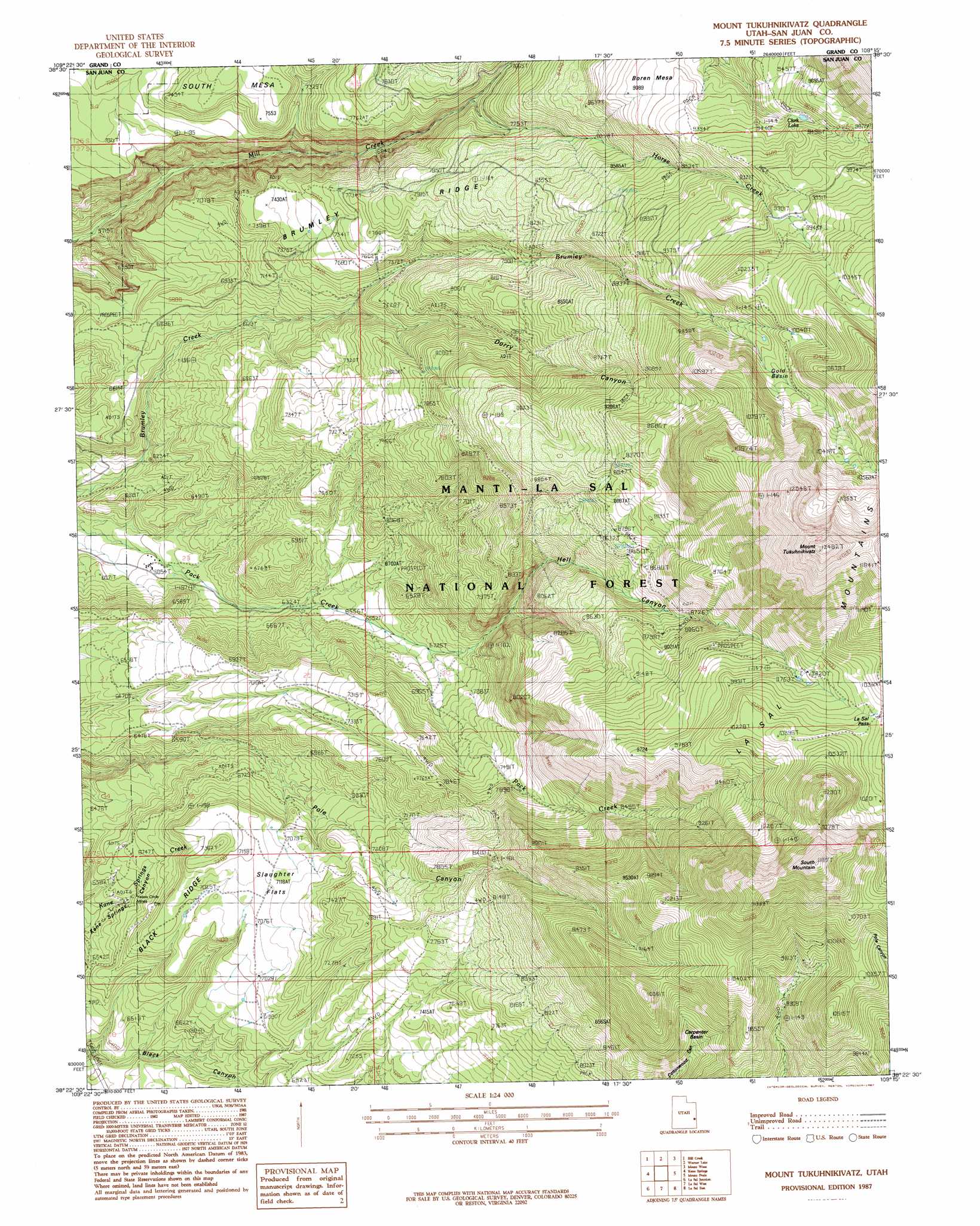
Mount Tukuhnikivatz Topo Map Utah
To zoom in, hover over the map of Mount Tukuhnikivatz
USGS Topo Quad 38109d3 - 1:24,000 scale
| Topo Map Name: | Mount Tukuhnikivatz |
| USGS Topo Quad ID: | 38109d3 |
| Print Size: | ca. 21 1/4" wide x 27" high |
| Southeast Coordinates: | 38.375° N latitude / 109.25° W longitude |
| Map Center Coordinates: | 38.4375° N latitude / 109.3125° W longitude |
| U.S. State: | UT |
| Filename: | o38109d3.jpg |
| Download Map JPG Image: | Mount Tukuhnikivatz topo map 1:24,000 scale |
| Map Type: | Topographic |
| Topo Series: | 7.5´ |
| Map Scale: | 1:24,000 |
| Source of Map Images: | United States Geological Survey (USGS) |
| Alternate Map Versions: |
Mt Peale 2 NE UT 1954, updated 1956 Download PDF Buy paper map Mount Tukuhnikivatz UT 1987, updated 1987 Download PDF Buy paper map Mount Tukuhnikivatz UT 1987, updated 1987 Download PDF Buy paper map Mount Tukuhnikivatz UT 2001, updated 2004 Download PDF Buy paper map Mount Tukuhnikivatz UT 2011 Download PDF Buy paper map Mount Tukuhnikivatz UT 2014 Download PDF Buy paper map |
| FStopo: | US Forest Service topo Mount Tukuhnikivatz is available: Download FStopo PDF Download FStopo TIF |
1:24,000 Topo Quads surrounding Mount Tukuhnikivatz
The Windows Section |
Big Bend |
Fisher Towers |
Fisher Valley |
Dolores Point North |
Moab |
Rill Creek |
Warner Lake |
Mount Waas |
Dolores Point South |
Trough Springs Canyon |
Kane Springs |
Mount Tukuhnikivatz |
Mount Peale |
Buckeye Reservoir |
Eightmile Rock |
La Sal Junction |
La Sal West |
La Sal East |
Wray Mesa |
Harts Point North |
Hatch Rock |
Sandstone Draw |
Lisbon Valley |
Lisbon Gap |
> Back to 38109a1 at 1:100,000 scale
> Back to 38108a1 at 1:250,000 scale
> Back to U.S. Topo Maps home
Mount Tukuhnikivatz topo map: Gazetteer
Mount Tukuhnikivatz: Basins
Carpenter Basin elevation 2649m 8690′Gold Basin elevation 3066m 10059′
Mount Tukuhnikivatz: Bridges
Mill Creek Bridge elevation 2335m 7660′Mount Tukuhnikivatz: Flats
Slaughter Flats elevation 2172m 7125′Mount Tukuhnikivatz: Gaps
La Sal Pass elevation 3089m 10134′Mount Tukuhnikivatz: Lakes
Clark Lake elevation 2860m 9383′Mount Tukuhnikivatz: Mines
Chess Ridge Mine elevation 2282m 7486′LaSal Pass Mine elevation 2720m 8923′
Yellow Circle Mines elevation 1976m 6482′
Mount Tukuhnikivatz: Parks
Pack Creek Picnic Area elevation 1958m 6423′Mount Tukuhnikivatz: Ridges
Black Ridge elevation 2039m 6689′Brumley Ridge elevation 2288m 7506′
Mount Tukuhnikivatz: Springs
Slaughter Spring elevation 2064m 6771′Squaw Spring elevation 2754m 9035′
Mount Tukuhnikivatz: Streams
Horse Creek elevation 2289m 7509′Mount Tukuhnikivatz: Summits
Mount Tukuhnikivatz elevation 3810m 12500′South Mountain elevation 3596m 11797′
Mount Tukuhnikivatz: Valleys
Dorry Canyon elevation 2138m 7014′Hell Canyon elevation 2024m 6640′
Mount Tukuhnikivatz digital topo map on disk
Buy this Mount Tukuhnikivatz topo map showing relief, roads, GPS coordinates and other geographical features, as a high-resolution digital map file on DVD: