Big Triangle Topo Map Utah
To zoom in, hover over the map of Big Triangle
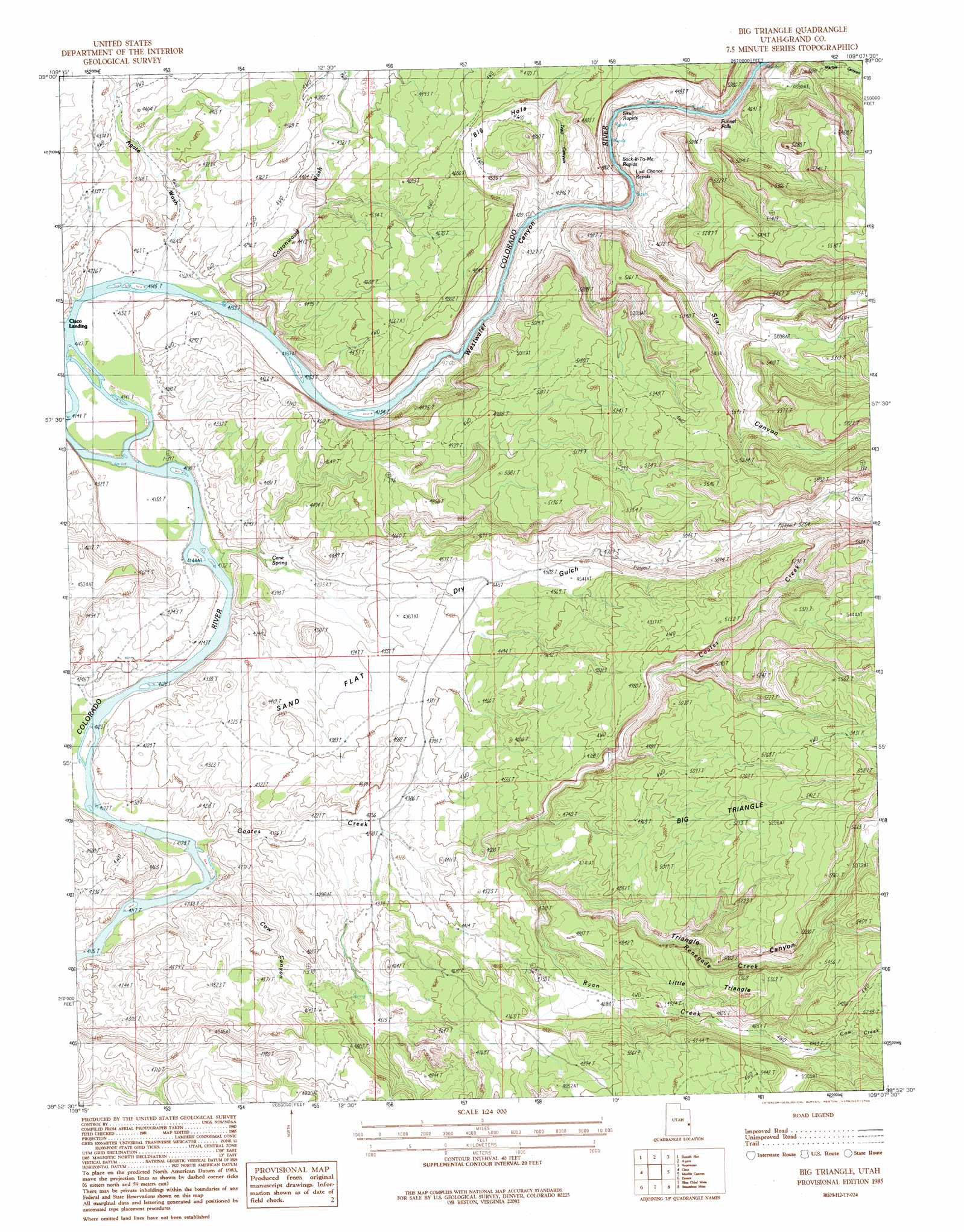
USGS Topo Quad 38109h2 - 1:24,000 scale
| Topo Map Name: | Big Triangle |
| USGS Topo Quad ID: | 38109h2 |
| Print Size: | ca. 21 1/4" wide x 27" high |
| Southeast Coordinates: | 38.875° N latitude / 109.125° W longitude |
| Map Center Coordinates: | 38.9375° N latitude / 109.1875° W longitude |
| U.S. State: | UT |
| Filename: | o38109h2.jpg |
| Download Map JPG Image: | Big Triangle topo map 1:24,000 scale |
| Map Type: | Topographic |
| Topo Series: | 7.5´ |
| Map Scale: | 1:24,000 |
| Source of Map Images: | United States Geological Survey (USGS) |
| Alternate Map Versions: |
Mt. Waas 1 NW UT 1954, updated 1956 Download PDF Buy paper map Big Triangle UT 1985, updated 1986 Download PDF Buy paper map Big Triangle UT 1985, updated 1986 Download PDF Buy paper map Big Triangle UT 2010 Download PDF Buy paper map Big Triangle UT 2014 Download PDF Buy paper map |
1:24,000 Topo Quads surrounding Big Triangle
Flume Canyon |
Antone Canyon |
Harley Dome |
Bitter Creek Well |
Ruby Canyon |
Cisco Springs |
Danish Flat |
Agate |
Westwater |
Sieber Canyon |
White House |
Cisco |
Big Triangle |
Marble Canyon |
Bieser Creek |
Cisco Sw |
Dewey |
Blue Chief Mesa |
Steamboat Mesa |
Two V Basin |
Big Bend |
Fisher Towers |
Fisher Valley |
Dolores Point North |
Gateway |
> Back to 38109e1 at 1:100,000 scale
> Back to 38108a1 at 1:250,000 scale
> Back to U.S. Topo Maps home
Big Triangle topo map: Gazetteer
Big Triangle: Basins
Big Hole elevation 1396m 4580′Big Triangle: Benches
Big Triangle elevation 1523m 4996′Little Triangle elevation 1558m 5111′
Big Triangle: Falls
Funnel Falls elevation 1286m 4219′Big Triangle: Flats
Sand Flat elevation 1326m 4350′Big Triangle: Rapids
Last Chance Rapids elevation 1283m 4209′Skull Rapids elevation 1277m 4189′
Sock-It-To-Me Rapids elevation 1276m 4186′
Big Triangle: Springs
Cane Spring elevation 1279m 4196′Big Triangle: Streams
Coach Creek elevation 1257m 4124′Coates Creek elevation 1258m 4127′
Cow Creek elevation 1516m 4973′
Renegade Creek elevation 1333m 4373′
Ryan Creek elevation 1332m 4370′
Big Triangle: Valleys
Agate Wash elevation 1268m 4160′Cottonwood Wash elevation 1267m 4156′
Cow Canyon elevation 1257m 4124′
Dry Gulch elevation 1305m 4281′
Ryans Gulch elevation 1352m 4435′
Star Canyon elevation 1284m 4212′
Trail Canyon elevation 1278m 4192′
Triangle Canyon elevation 1334m 4376′
Westwater Canyon elevation 1266m 4153′
Big Triangle digital topo map on disk
Buy this Big Triangle topo map showing relief, roads, GPS coordinates and other geographical features, as a high-resolution digital map file on DVD: