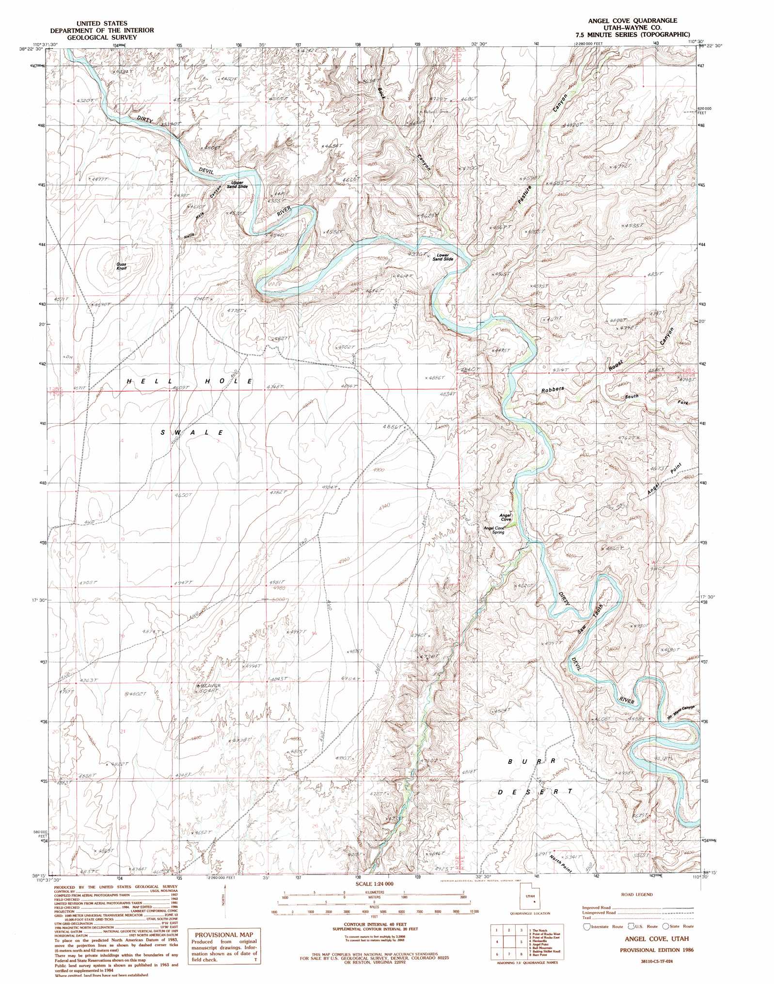
Angel Cove Topo Map Utah
To zoom in, hover over the map of Angel Cove
USGS Topo Quad 38110c5 - 1:24,000 scale
| Topo Map Name: | Angel Cove |
| USGS Topo Quad ID: | 38110c5 |
| Print Size: | ca. 21 1/4" wide x 27" high |
| Southeast Coordinates: | 38.25° N latitude / 110.5° W longitude |
| Map Center Coordinates: | 38.3125° N latitude / 110.5625° W longitude |
| U.S. State: | UT |
| Filename: | o38110c5.jpg |
| Download Map JPG Image: | Angel Cove topo map 1:24,000 scale |
| Map Type: | Topographic |
| Topo Series: | 7.5´ |
| Map Scale: | 1:24,000 |
| Source of Map Images: | United States Geological Survey (USGS) |
| Alternate Map Versions: |
Angel Cove UT 1986, updated 1987 Download PDF Buy paper map Angel Cove UT 1986, updated 1987 Download PDF Buy paper map Angel Cove UT 2010 Download PDF Buy paper map Angel Cove UT 2014 Download PDF Buy paper map |
1:24,000 Topo Quads surrounding Angel Cove
Little Wild Horse Mesa |
Goblin Valley |
Gilson Butte |
The Flat Tops |
Jacks Knob |
Skyline Rim |
The Notch |
Point Of Rocks West |
Point Of Rocks East |
Whitbeck Knoll |
Steamboat Point |
Hanksville |
Angel Cove |
Angel Point |
Robbers Roost Flats |
Dry Lakes Peak |
Bull Mountain |
Baking Skillet Knoll |
Burr Point |
The Pinnacle |
Mount Ellen |
Raggy Canyon |
Turkey Knob |
Stair Canyon |
Fiddler Butte |
> Back to 38110a1 at 1:100,000 scale
> Back to 38110a1 at 1:250,000 scale
> Back to U.S. Topo Maps home
Angel Cove topo map: Gazetteer
Angel Cove: Basins
Angel Cove elevation 1277m 4189′Hell Hole Swale elevation 1415m 4642′
Angel Cove: Capes
Saw Tooth elevation 1262m 4140′Angel Cove: Ridges
North Point elevation 1623m 5324′Angel Cove: Slopes
Lower Sand Slide elevation 1311m 4301′Upper Sand Slide elevation 1307m 4288′
Angel Cove: Springs
Angel Cove Spring elevation 1285m 4215′Angel Cove: Streams
Beaver Wash elevation 1295m 4248′Angel Cove: Summits
Guss Knoll elevation 1447m 4747′Angel Cove: Valleys
Beaver Canyon elevation 1253m 4110′Buck Canyon elevation 1268m 4160′
No Mans Canyon elevation 1261m 4137′
Pasture Canyon elevation 1283m 4209′
Robbers Roost Canyon elevation 1273m 4176′
South Fork Robbers Roost Canyon elevation 1280m 4199′
Angel Cove digital topo map on disk
Buy this Angel Cove topo map showing relief, roads, GPS coordinates and other geographical features, as a high-resolution digital map file on DVD: