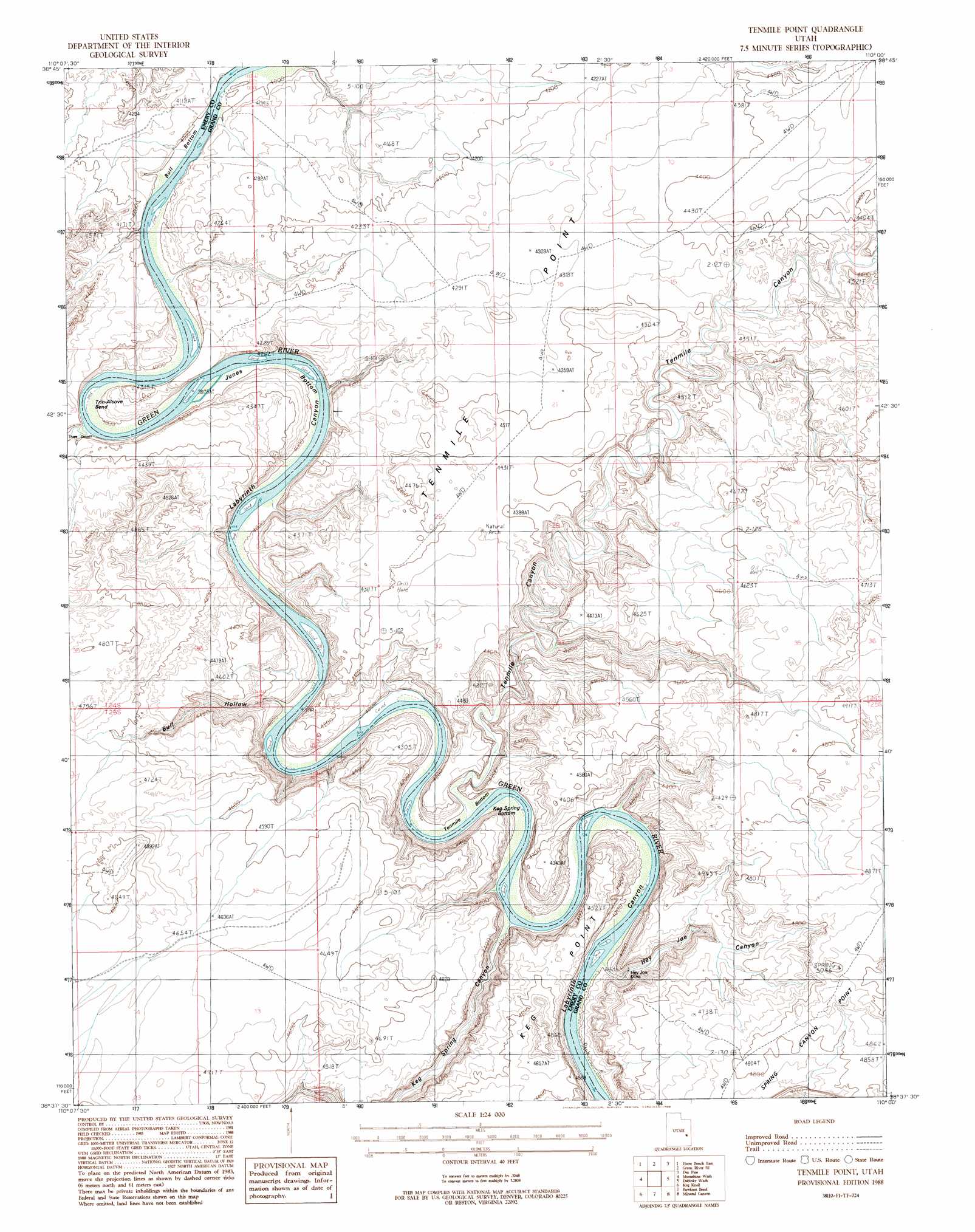
Tenmile Point Topo Map Utah
To zoom in, hover over the map of Tenmile Point
USGS Topo Quad 38110f1 - 1:24,000 scale
| Topo Map Name: | Tenmile Point |
| USGS Topo Quad ID: | 38110f1 |
| Print Size: | ca. 21 1/4" wide x 27" high |
| Southeast Coordinates: | 38.625° N latitude / 110° W longitude |
| Map Center Coordinates: | 38.6875° N latitude / 110.0625° W longitude |
| U.S. State: | UT |
| Filename: | o38110f1.jpg |
| Download Map JPG Image: | Tenmile Point topo map 1:24,000 scale |
| Map Type: | Topographic |
| Topo Series: | 7.5´ |
| Map Scale: | 1:24,000 |
| Source of Map Images: | United States Geological Survey (USGS) |
| Alternate Map Versions: |
Tidwell 4 NE UT 1952, updated 1954 Download PDF Buy paper map Tenmile Point UT 1988, updated 1988 Download PDF Buy paper map Tenmile Point UT 2011 Download PDF Buy paper map Tenmile Point UT 2014 Download PDF Buy paper map |
1:24,000 Topo Quads surrounding Tenmile Point
Jessies Twist |
Green River |
Green River Ne |
Hatch Mesa |
Crescent Junction |
Horse Bench West |
Horse Bench East |
Green River Se |
Dee Pass |
Valley City |
Spring Canyon |
Moonshine Wash |
Tenmile Point |
Dubinky Wash |
Jug Rock |
Jacks Knob |
Keg Knoll |
Bowknot Bend |
Mineral Canyon |
The Knoll |
Whitbeck Knoll |
Sugarloaf Butte |
Horsethief Canyon |
Upheaval Dome |
Musselman Arch |
> Back to 38110e1 at 1:100,000 scale
> Back to 38110a1 at 1:250,000 scale
> Back to U.S. Topo Maps home
Tenmile Point topo map: Gazetteer
Tenmile Point: Bends
Bull Bottom elevation 1240m 4068′Junes Bottom elevation 1228m 4028′
Keg Spring Bottom elevation 1216m 3989′
Tenmile Bottom elevation 1212m 3976′
Trin-Alcove Bend elevation 1249m 4097′
Tenmile Point: Mines
Hey Joe Mine elevation 1280m 4199′Tenmile Point: Ridges
Tenmile Point elevation 1326m 4350′Tenmile Point: Valleys
Bull Hollow elevation 1213m 3979′Hey Joe Canyon elevation 1223m 4012′
Keg Spring Canyon elevation 1243m 4078′
Tenmile Canyon elevation 1213m 3979′
Three Canyon elevation 1217m 3992′
Trail Canyon elevation 1303m 4274′
Tenmile Point digital topo map on disk
Buy this Tenmile Point topo map showing relief, roads, GPS coordinates and other geographical features, as a high-resolution digital map file on DVD: