Old Woman Wash Topo Map Utah
To zoom in, hover over the map of Old Woman Wash
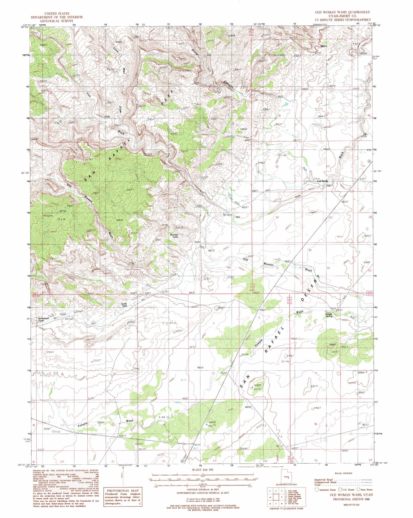
USGS Topo Quad 38110f5 - 1:24,000 scale
| Topo Map Name: | Old Woman Wash |
| USGS Topo Quad ID: | 38110f5 |
| Print Size: | ca. 21 1/4" wide x 27" high |
| Southeast Coordinates: | 38.625° N latitude / 110.5° W longitude |
| Map Center Coordinates: | 38.6875° N latitude / 110.5625° W longitude |
| U.S. State: | UT |
| Filename: | o38110f5.jpg |
| Download Map JPG Image: | Old Woman Wash topo map 1:24,000 scale |
| Map Type: | Topographic |
| Topo Series: | 7.5´ |
| Map Scale: | 1:24,000 |
| Source of Map Images: | United States Geological Survey (USGS) |
| Alternate Map Versions: |
Stinking Spring Creek 4 NE UT 1954 Download PDF Buy paper map Old Woman Wash UT 1988, updated 1988 Download PDF Buy paper map Old Woman Wash UT 2010 Download PDF Buy paper map Old Woman Wash UT 2014 Download PDF Buy paper map |
1:24,000 Topo Quads surrounding Old Woman Wash
The Blocks |
The Wickiup |
Drowned Hole Draw |
Spotted Wolf Canyon |
Jessies Twist |
San Rafael Knob |
Twin Knolls |
Arsons Garden |
Greasewood Draw |
Horse Bench West |
Horse Valley |
Temple Mountain |
Old Woman Wash |
Crows Nest Spring |
Spring Canyon |
Little Wild Horse Mesa |
Goblin Valley |
Gilson Butte |
The Flat Tops |
Jacks Knob |
Skyline Rim |
The Notch |
Point Of Rocks West |
Point Of Rocks East |
Whitbeck Knoll |
> Back to 38110e1 at 1:100,000 scale
> Back to 38110a1 at 1:250,000 scale
> Back to U.S. Topo Maps home
Old Woman Wash topo map: Gazetteer
Old Woman Wash: Reservoirs
Farnsworth Tanks elevation 1596m 5236′Mormon Tanks elevation 1537m 5042′
Old Woman Wash: Springs
Lost Spring elevation 1477m 4845′Lost Spring elevation 1458m 4783′
Swazy Seep elevation 1532m 5026′
Temple Spring elevation 1464m 4803′
Old Woman Wash: Valleys
Lone Man Draw elevation 1555m 5101′Old Woman Wash elevation 1448m 4750′
Temple Wash elevation 1445m 4740′
Old Woman Wash digital topo map on disk
Buy this Old Woman Wash topo map showing relief, roads, GPS coordinates and other geographical features, as a high-resolution digital map file on DVD: