Green River Topo Map Utah
To zoom in, hover over the map of Green River
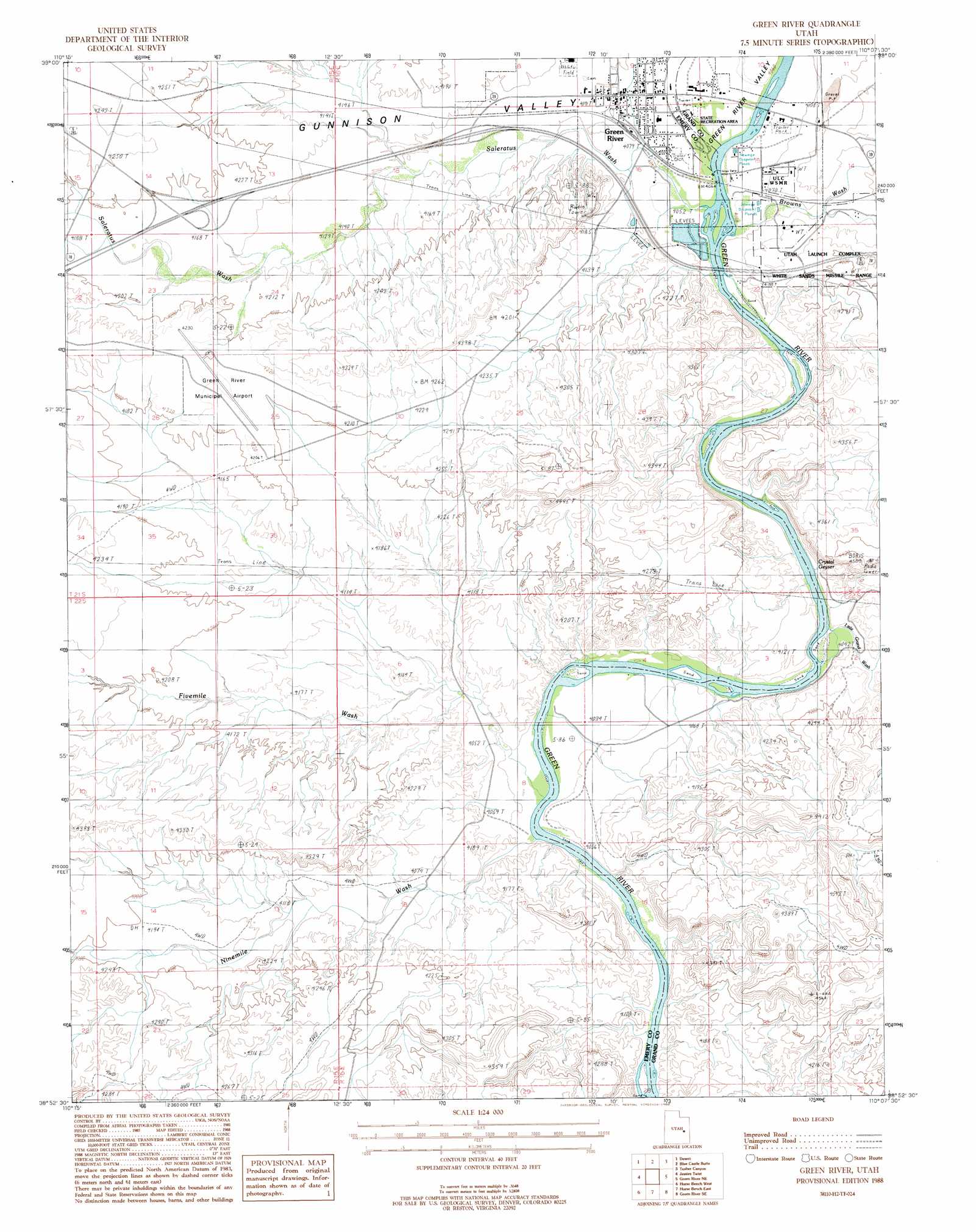
USGS Topo Quad 38110h2 - 1:24,000 scale
| Topo Map Name: | Green River |
| USGS Topo Quad ID: | 38110h2 |
| Print Size: | ca. 21 1/4" wide x 27" high |
| Southeast Coordinates: | 38.875° N latitude / 110.125° W longitude |
| Map Center Coordinates: | 38.9375° N latitude / 110.1875° W longitude |
| U.S. State: | UT |
| Filename: | o38110h2.jpg |
| Download Map JPG Image: | Green River topo map 1:24,000 scale |
| Map Type: | Topographic |
| Topo Series: | 7.5´ |
| Map Scale: | 1:24,000 |
| Source of Map Images: | United States Geological Survey (USGS) |
| Alternate Map Versions: |
Tidwell 1 NW UT 1954, updated 1955 Download PDF Buy paper map Green River UT 1988, updated 1988 Download PDF Buy paper map Green River UT 1988, updated 1988 Download PDF Buy paper map Green River UT 2010 Download PDF Buy paper map Green River UT 2014 Download PDF Buy paper map |
1:24,000 Topo Quads surrounding Green River
Dry Mesa |
Cliff |
Jenny Canyon |
Butler Canyon |
Bobby Canyon North |
Mexican Mountain |
Desert |
Blue Castle Butte |
Tusher Canyon |
Bobby Canyon South |
Spotted Wolf Canyon |
Jessies Twist |
Green River |
Green River Ne |
Hatch Mesa |
Greasewood Draw |
Horse Bench West |
Horse Bench East |
Green River Se |
Dee Pass |
Crows Nest Spring |
Spring Canyon |
Moonshine Wash |
Tenmile Point |
Dubinky Wash |
> Back to 38110e1 at 1:100,000 scale
> Back to 38110a1 at 1:250,000 scale
> Back to U.S. Topo Maps home
Green River topo map: Gazetteer
Green River: Airports
Green River Airport elevation 1251m 4104′Green River Heliport elevation 1292m 4238′
Green River: Parks
Green River State Park elevation 1258m 4127′Green River State Recreation Area elevation 1238m 4061′
Green River: Populated Places
Elgin elevation 1241m 4071′Green River elevation 1242m 4074′
Green River: Post Offices
Green River Post Office elevation 1243m 4078′Green River: Springs
Crystal Geyser elevation 1238m 4061′Green River: Valleys
Browns Wash elevation 1233m 4045′Fivemile Wash elevation 1225m 4019′
Little Grand Wash elevation 1230m 4035′
Ninemile Wash elevation 1233m 4045′
Saleratus Wash elevation 1233m 4045′
Green River digital topo map on disk
Buy this Green River topo map showing relief, roads, GPS coordinates and other geographical features, as a high-resolution digital map file on DVD: