Big Lake Topo Map Utah
To zoom in, hover over the map of Big Lake
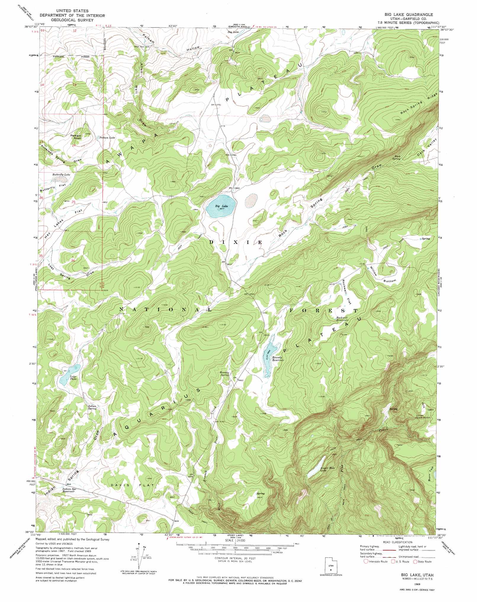
USGS Topo Quad 38111a6 - 1:24,000 scale
| Topo Map Name: | Big Lake |
| USGS Topo Quad ID: | 38111a6 |
| Print Size: | ca. 21 1/4" wide x 27" high |
| Southeast Coordinates: | 38° N latitude / 111.625° W longitude |
| Map Center Coordinates: | 38.0625° N latitude / 111.6875° W longitude |
| U.S. State: | UT |
| Filename: | o38111a6.jpg |
| Download Map JPG Image: | Big Lake topo map 1:24,000 scale |
| Map Type: | Topographic |
| Topo Series: | 7.5´ |
| Map Scale: | 1:24,000 |
| Source of Map Images: | United States Geological Survey (USGS) |
| Alternate Map Versions: |
Big Lake UT 1969, updated 1973 Download PDF Buy paper map Big Lake UT 2002, updated 2005 Download PDF Buy paper map Big Lake UT 2011 Download PDF Buy paper map Big Lake UT 2014 Download PDF Buy paper map |
| FStopo: | US Forest Service topo Big Lake is available: Download FStopo PDF Download FStopo TIF |
1:24,000 Topo Quads surrounding Big Lake
Parker Knoll |
Jakes Knoll |
Moroni Peak |
Bicknell |
Torrey |
Angle |
Flossie Knoll |
Smooth Knoll |
Government Point |
Blind Lake |
Antimony |
Pollywog Lake |
Big Lake |
Jacobs Reservoir |
Deer Creek Lake |
Grass Lakes |
Barker Reservoir |
Posy Lake |
Roger Peak |
Boulder Town |
Sweetwater Creek |
Griffin Point |
Wide Hollow Reservoir |
Escalante |
Calf Creek |
> Back to 38111a1 at 1:100,000 scale
> Back to 38110a1 at 1:250,000 scale
> Back to U.S. Topo Maps home
Big Lake topo map: Gazetteer
Big Lake: Dams
Roundy Reservoir Dam elevation 3038m 9967′Big Lake: Flats
Butterfly Flat elevation 2964m 9724′Davis Flat elevation 2982m 9783′
Rockwell Flat elevation 3096m 10157′
Willow Bottom elevation 3093m 10147′
Big Lake: Lakes
Auger Hole Lake elevation 2803m 9196′Big Lake elevation 3012m 9881′
Butterfly Lake elevation 2964m 9724′
Lake Philo elevation 3022m 9914′
Pelham Lake elevation 2951m 9681′
Big Lake: Plains
Aquarius Plateau elevation 3014m 9888′Big Lake: Reservoirs
Indian Spring Reservoir elevation 2942m 9652′Rockwell Reservoir elevation 3096m 10157′
Roundy Reservoir elevation 3038m 9967′
Big Lake: Springs
Indian Spring elevation 3010m 9875′Rock Spring elevation 2869m 9412′
Roundy Spring elevation 3025m 9924′
Big Lake: Summits
Pelham Knoll elevation 2976m 9763′Big Lake: Valleys
Allen Well Draw elevation 2828m 9278′Rock Spring Draw elevation 2855m 9366′
Big Lake: Wells
Allen Well elevation 2831m 9288′Big Lake digital topo map on disk
Buy this Big Lake topo map showing relief, roads, GPS coordinates and other geographical features, as a high-resolution digital map file on DVD: