Government Point Topo Map Utah
To zoom in, hover over the map of Government Point
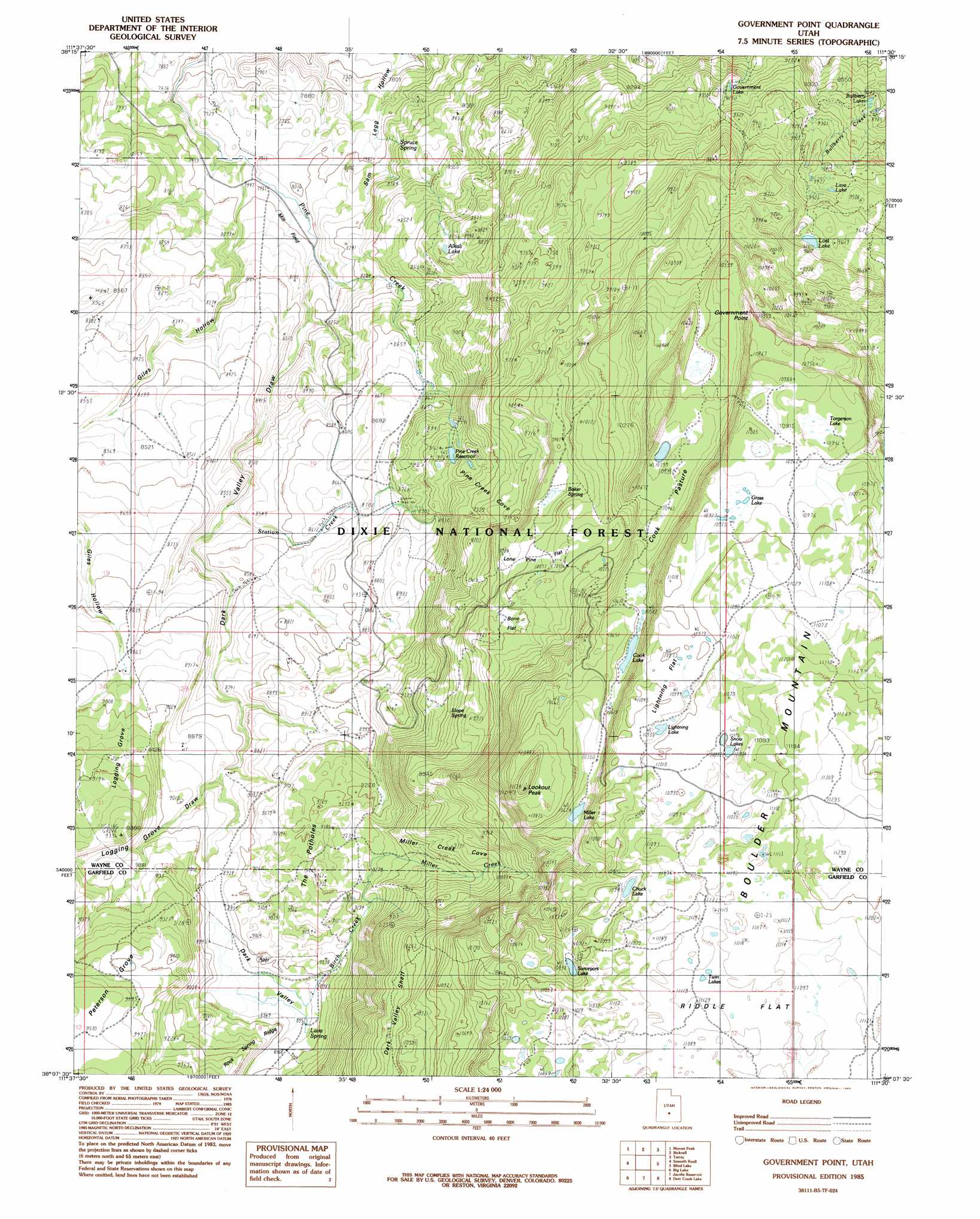
USGS Topo Quad 38111b5 - 1:24,000 scale
| Topo Map Name: | Government Point |
| USGS Topo Quad ID: | 38111b5 |
| Print Size: | ca. 21 1/4" wide x 27" high |
| Southeast Coordinates: | 38.125° N latitude / 111.5° W longitude |
| Map Center Coordinates: | 38.1875° N latitude / 111.5625° W longitude |
| U.S. State: | UT |
| Filename: | o38111b5.jpg |
| Download Map JPG Image: | Government Point topo map 1:24,000 scale |
| Map Type: | Topographic |
| Topo Series: | 7.5´ |
| Map Scale: | 1:24,000 |
| Source of Map Images: | United States Geological Survey (USGS) |
| Alternate Map Versions: |
Loa 4 NE UT 1953, updated 1954 Download PDF Buy paper map Government Point UT 1985, updated 1985 Download PDF Buy paper map Government Point UT 2002, updated 2005 Download PDF Buy paper map Government Point UT 2011 Download PDF Buy paper map Government Point UT 2014 Download PDF Buy paper map |
| FStopo: | US Forest Service topo Government Point is available: Download FStopo PDF Download FStopo TIF |
1:24,000 Topo Quads surrounding Government Point
Abes Knoll |
Loa |
Lyman |
Flat Top |
Cathedral Mountain |
Jakes Knoll |
Moroni Peak |
Bicknell |
Torrey |
Twin Rocks |
Flossie Knoll |
Smooth Knoll |
Government Point |
Blind Lake |
Grover |
Pollywog Lake |
Big Lake |
Jacobs Reservoir |
Deer Creek Lake |
Lower Bowns Reservoir |
Barker Reservoir |
Posy Lake |
Roger Peak |
Boulder Town |
Steep Creek Bench |
> Back to 38111a1 at 1:100,000 scale
> Back to 38110a1 at 1:250,000 scale
> Back to U.S. Topo Maps home
Government Point topo map: Gazetteer
Government Point: Areas
Mill Field elevation 2442m 8011′Government Point: Capes
Government Point elevation 3300m 10826′Government Point: Dams
Pine Creek Reservoir Dam elevation 2780m 9120′Government Point: Flats
Cook Pasture elevation 3228m 10590′Lightning Flat elevation 3350m 10990′
Lone Pine Flat elevation 3056m 10026′
Government Point: Lakes
Alkali Lake elevation 2671m 8763′Bullberry Lakes elevation 2750m 9022′
Chuck Lake elevation 3338m 10951′
Cook Lake elevation 3230m 10597′
Government Lake elevation 2815m 9235′
Grass Lake elevation 3339m 10954′
Lava Lake elevation 2878m 9442′
Lightning Lake elevation 3358m 11017′
Lost Lake elevation 2936m 9632′
Miller Lake elevation 3240m 10629′
Snow Lakes elevation 3353m 11000′
Surveyors Lake elevation 3301m 10830′
Torgerson Lake elevation 3338m 10951′
Twin Lakes elevation 3390m 11122′
Twin Lakes elevation 3390m 11122′
West Lake elevation 3399m 11151′
Government Point: Ranges
The Potholes elevation 2817m 9242′Government Point: Reservoirs
Pine Creek Reservoir elevation 2781m 9124′Government Point: Slopes
Miller Creek Cove elevation 2946m 9665′Pine Creek Cove elevation 2876m 9435′
Government Point: Springs
Baker Spring elevation 3039m 9970′Lava Spring elevation 2734m 8969′
Slope Spring elevation 2941m 9648′
Spruce Spring elevation 2518m 8261′
Government Point: Streams
Birch Creek elevation 2723m 8933′Miller Creek elevation 2647m 8684′
Station Creek elevation 2567m 8421′
Government Point: Summits
Lookout Peak elevation 3379m 11085′Pinto Knoll elevation 3391m 11125′
Government Point: Trails
Aquarius Trail elevation 2631m 8631′Pollywog Lake Trail elevation 2610m 8562′
Government Point: Valleys
Dark Valley elevation 2424m 7952′Dark Valley Draw elevation 2478m 8129′
Giles Hollow elevation 2414m 7919′
Logging Grove Draw elevation 2683m 8802′
Government Point: Woods
Logging Grove elevation 2789m 9150′Peterson Grove elevation 2877m 9438′
Government Point digital topo map on disk
Buy this Government Point topo map showing relief, roads, GPS coordinates and other geographical features, as a high-resolution digital map file on DVD: