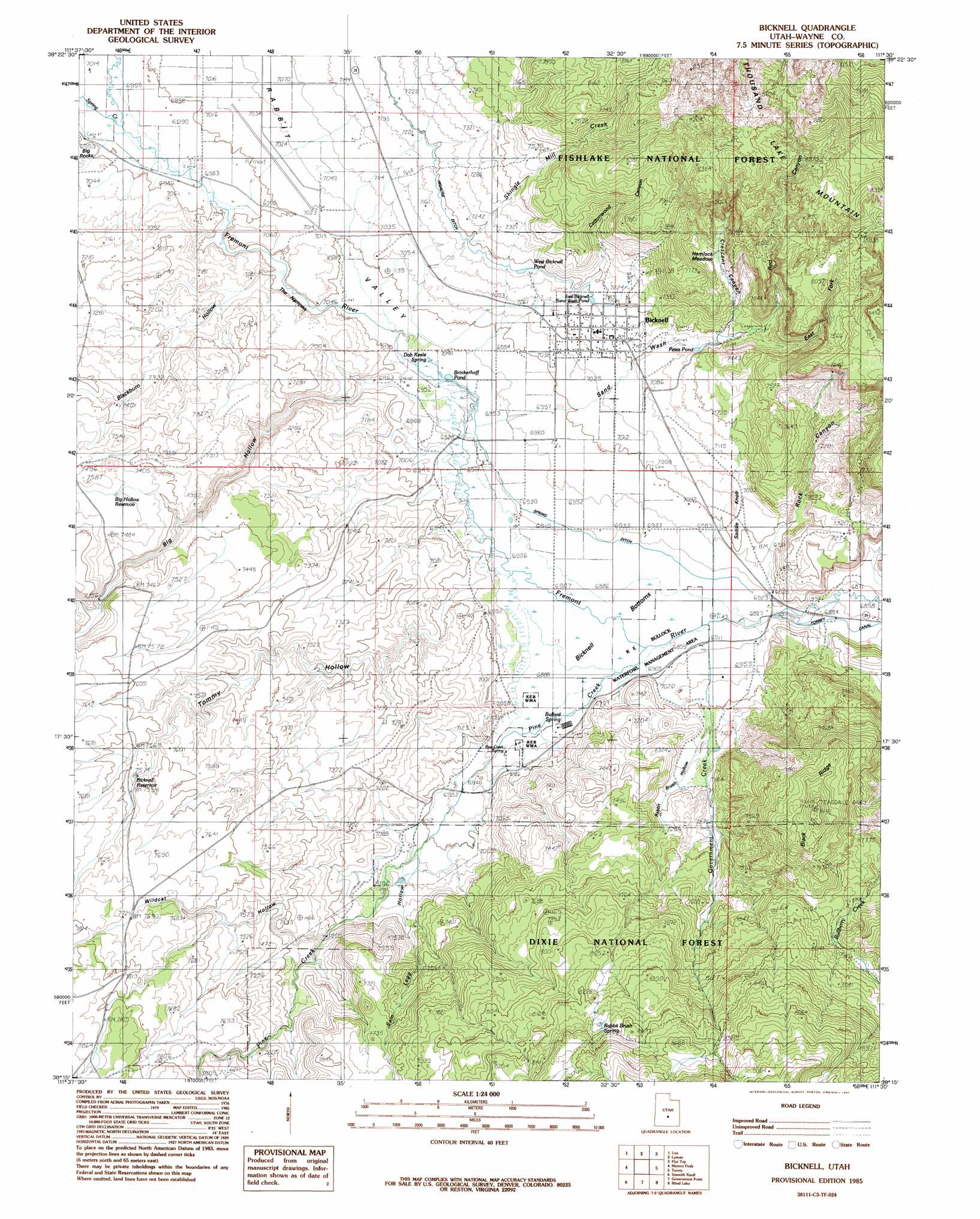
Bicknell Topo Map Utah
To zoom in, hover over the map of Bicknell
USGS Topo Quad 38111c5 - 1:24,000 scale
| Topo Map Name: | Bicknell |
| USGS Topo Quad ID: | 38111c5 |
| Print Size: | ca. 21 1/4" wide x 27" high |
| Southeast Coordinates: | 38.25° N latitude / 111.5° W longitude |
| Map Center Coordinates: | 38.3125° N latitude / 111.5625° W longitude |
| U.S. State: | UT |
| Filename: | o38111c5.jpg |
| Download Map JPG Image: | Bicknell topo map 1:24,000 scale |
| Map Type: | Topographic |
| Topo Series: | 7.5´ |
| Map Scale: | 1:24,000 |
| Source of Map Images: | United States Geological Survey (USGS) |
| Alternate Map Versions: |
Loa 1 SE UT 1952, updated 1954 Download PDF Buy paper map Bicknell UT 1985, updated 1985 Download PDF Buy paper map Bicknell UT 2002, updated 2005 Download PDF Buy paper map Bicknell UT 2011 Download PDF Buy paper map Bicknell UT 2014 Download PDF Buy paper map |
| FStopo: | US Forest Service topo Bicknell is available: Download FStopo PDF Download FStopo TIF |
1:24,000 Topo Quads surrounding Bicknell
Burrville |
Fish Lake |
Forsyth Reservoir |
Geyser Peak |
Solomons Temple |
Abes Knoll |
Loa |
Lyman |
Flat Top |
Cathedral Mountain |
Jakes Knoll |
Moroni Peak |
Bicknell |
Torrey |
Twin Rocks |
Flossie Knoll |
Smooth Knoll |
Government Point |
Blind Lake |
Grover |
Pollywog Lake |
Big Lake |
Jacobs Reservoir |
Deer Creek Lake |
Lower Bowns Reservoir |
> Back to 38111a1 at 1:100,000 scale
> Back to 38110a1 at 1:250,000 scale
> Back to U.S. Topo Maps home
Bicknell topo map: Gazetteer
Bicknell: Airports
Wayne Wonderland Airport elevation 2140m 7020′Bicknell: Canals
Spring Ditch elevation 2110m 6922′Tub Ditch elevation 2119m 6952′
Bicknell: Flats
Bicknell Bottoms elevation 2103m 6899′Hemlock Meadow elevation 2265m 7431′
Bicknell: Forests
Dixie National Forest elevation 2667m 8750′Bicknell: Gaps
The Narrows elevation 2129m 6984′Bicknell: Parks
KE Bullock Waterfowl Management Area elevation 2110m 6922′Bicknell: Populated Places
Bicknell elevation 2171m 7122′Bicknell: Post Offices
Bicknell Post Office elevation 2131m 6991′Bicknell: Reservoirs
Bicknell Reservoir elevation 2306m 7565′Big Hollow Reservoir elevation 2281m 7483′
Brinkerhoff Pond elevation 2112m 6929′
East Bicknell Sand Wash Pond elevation 2184m 7165′
Petes Pond elevation 2180m 7152′
West Bicknell Pond elevation 2187m 7175′
Bicknell: Ridges
Black Ridge elevation 2576m 8451′Bicknell: Springs
Bullard Spring elevation 2107m 6912′Dab Keele Spring elevation 2118m 6948′
Pine Creek Spring elevation 2110m 6922′
Rabbit Brush Spring elevation 2556m 8385′
Bicknell: Streams
Government Creek elevation 2099m 6886′Pine Creek elevation 2104m 6902′
Shingle Mill Creek elevation 2126m 6975′
Spring Creek elevation 2133m 6998′
Trail Creek elevation 2154m 7066′
Bicknell: Summits
Saddle Knoll elevation 2160m 7086′Bicknell: Valleys
Big Hollow elevation 2121m 6958′Blackburn Hollow elevation 2132m 6994′
Cottonwood Canyon elevation 2186m 7171′
Crescent Canyon elevation 2185m 7168′
East Fork Red Canyon elevation 2207m 7240′
Lee Hollow elevation 2110m 6922′
Pole Canyon elevation 2291m 7516′
Rabbit Brush Hollow elevation 2105m 6906′
Rabbit Valley elevation 2132m 6994′
Red Canyon elevation 2178m 7145′
Rock Canyon elevation 2127m 6978′
Sage Flat Draw elevation 2244m 7362′
Sam Legg Hollow elevation 2176m 7139′
Sand Wash elevation 2121m 6958′
Tommy Hollow elevation 2121m 6958′
Upper Corral Canyon elevation 2180m 7152′
Wildcat Hollow elevation 2295m 7529′
Bicknell digital topo map on disk
Buy this Bicknell topo map showing relief, roads, GPS coordinates and other geographical features, as a high-resolution digital map file on DVD: