Cathedral Mountain Topo Map Utah
To zoom in, hover over the map of Cathedral Mountain
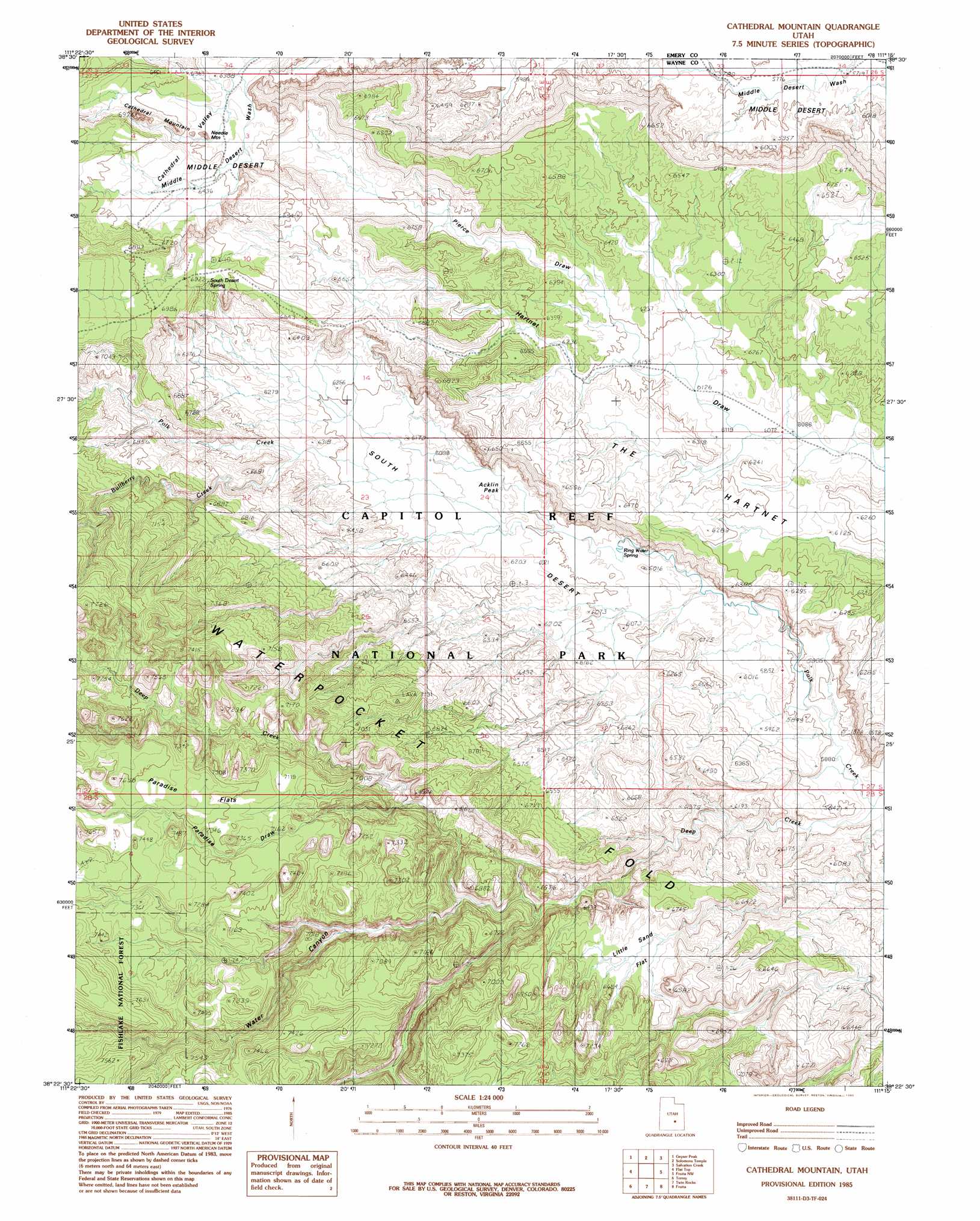
USGS Topo Quad 38111d3 - 1:24,000 scale
| Topo Map Name: | Cathedral Mountain |
| USGS Topo Quad ID: | 38111d3 |
| Print Size: | ca. 21 1/4" wide x 27" high |
| Southeast Coordinates: | 38.375° N latitude / 111.25° W longitude |
| Map Center Coordinates: | 38.4375° N latitude / 111.3125° W longitude |
| U.S. State: | UT |
| Filename: | o38111d3.jpg |
| Download Map JPG Image: | Cathedral Mountain topo map 1:24,000 scale |
| Map Type: | Topographic |
| Topo Series: | 7.5´ |
| Map Scale: | 1:24,000 |
| Source of Map Images: | United States Geological Survey (USGS) |
| Alternate Map Versions: |
Notom 2 NE UT 1952, updated 1954 Download PDF Buy paper map Cathedral Mountain UT 1985, updated 1985 Download PDF Buy paper map Cathedral Mountain UT 2001, updated 2003 Download PDF Buy paper map Cathedral Mountain UT 2011 Download PDF Buy paper map Cathedral Mountain UT 2014 Download PDF Buy paper map |
| FStopo: | US Forest Service topo Cathedral Mountain is available: Download FStopo PDF Download FStopo TIF |
1:24,000 Topo Quads surrounding Cathedral Mountain
Hilgard Mountain |
Johns Peak |
Willow Springs |
Mussentuchit Flat |
Ireland Mesa |
Forsyth Reservoir |
Geyser Peak |
Solomons Temple |
Salvation Creek |
The Frying Pan |
Lyman |
Flat Top |
Cathedral Mountain |
Fruita Nw |
Caine Springs |
Bicknell |
Torrey |
Twin Rocks |
Fruita |
Caineville |
Government Point |
Blind Lake |
Grover |
Golden Throne |
Notom |
> Back to 38111a1 at 1:100,000 scale
> Back to 38110a1 at 1:250,000 scale
> Back to U.S. Topo Maps home
Cathedral Mountain topo map: Gazetteer
Cathedral Mountain: Areas
Cathedral Valley elevation 1959m 6427′Cathedral Mountain: Basins
Gypsum Sinkhole elevation 1819m 5967′Cathedral Mountain: Flats
Little Sand Flat elevation 1974m 6476′Paradise Flats elevation 2234m 7329′
Cathedral Mountain: Springs
Ring Water Spring elevation 1811m 5941′South Desert Spring elevation 2120m 6955′
Cathedral Mountain: Streams
Bullberry Creek elevation 1913m 6276′Collins Creek elevation 1921m 6302′
Polk Creek elevation 1742m 5715′
Cathedral Mountain: Summits
Acklin Peak elevation 1854m 6082′Cathedral Mountain elevation 2103m 6899′
Needle Mountain elevation 1938m 6358′
Cathedral Mountain: Valleys
Paradise Draw elevation 1967m 6453′Pierce Draw elevation 1902m 6240′
Water Canyon elevation 1912m 6272′
Cathedral Mountain digital topo map on disk
Buy this Cathedral Mountain topo map showing relief, roads, GPS coordinates and other geographical features, as a high-resolution digital map file on DVD: