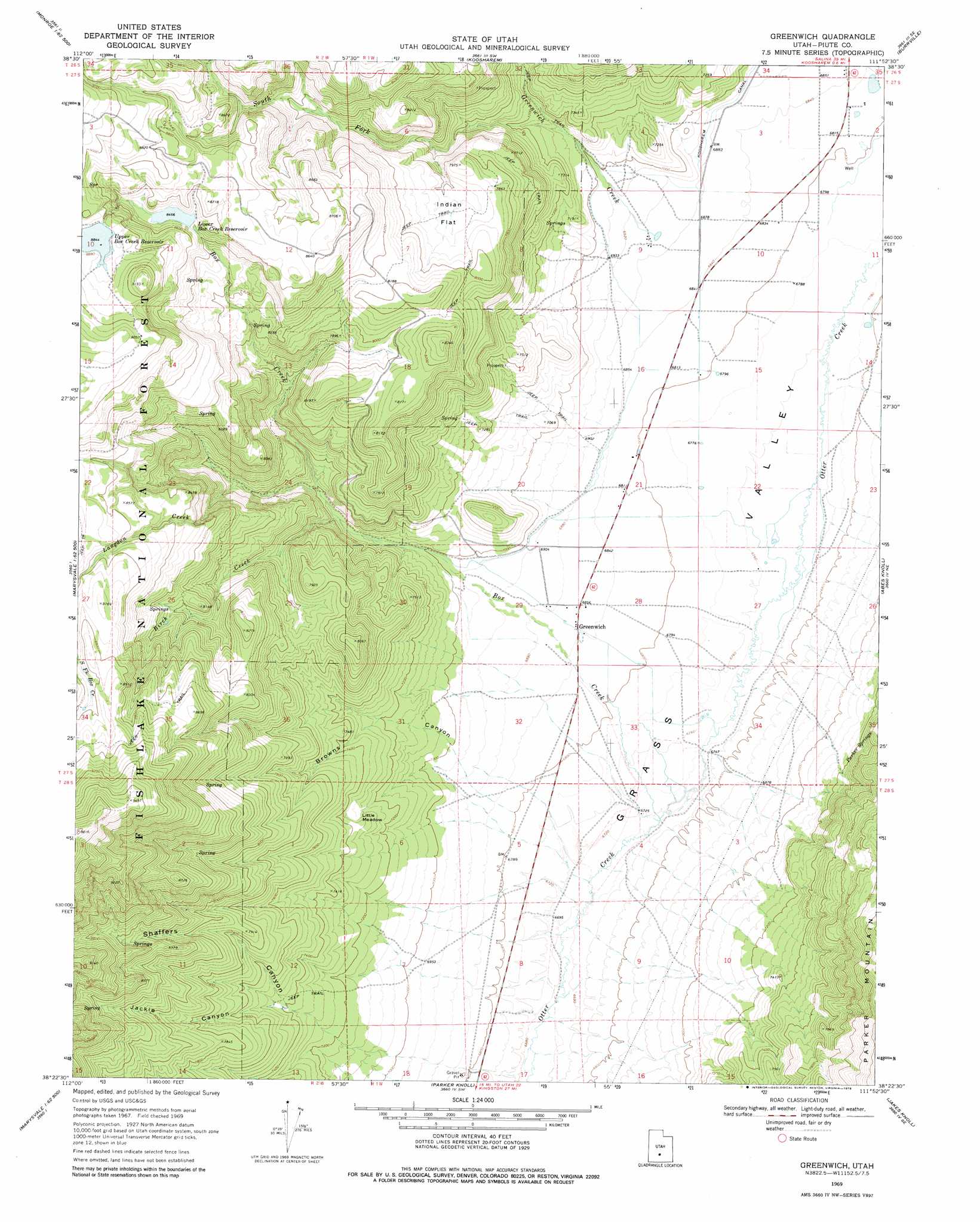
Greenwich Topo Map Utah
To zoom in, hover over the map of Greenwich
USGS Topo Quad 38111d8 - 1:24,000 scale
| Topo Map Name: | Greenwich |
| USGS Topo Quad ID: | 38111d8 |
| Print Size: | ca. 21 1/4" wide x 27" high |
| Southeast Coordinates: | 38.375° N latitude / 111.875° W longitude |
| Map Center Coordinates: | 38.4375° N latitude / 111.9375° W longitude |
| U.S. State: | UT |
| Filename: | o38111d8.jpg |
| Download Map JPG Image: | Greenwich topo map 1:24,000 scale |
| Map Type: | Topographic |
| Topo Series: | 7.5´ |
| Map Scale: | 1:24,000 |
| Source of Map Images: | United States Geological Survey (USGS) |
| Alternate Map Versions: |
Greenwich UT 1969, updated 1972 Download PDF Buy paper map Greenwich UT 1969, updated 1978 Download PDF Buy paper map Greenwich UT 2001, updated 2003 Download PDF Buy paper map Greenwich UT 2011 Download PDF Buy paper map Greenwich UT 2014 Download PDF Buy paper map |
| FStopo: | US Forest Service topo Greenwich is available: Download FStopo PDF Download FStopo TIF |
1:24,000 Topo Quads surrounding Greenwich
Elsinore |
Annabella |
Water Creek Canyon |
Boobe Hole Reservoir |
Mount Terrill |
Antelope Range |
Monroe Peak |
Koosharem |
Burrville |
Fish Lake |
Marysvale |
Marysvale Peak |
Greenwich |
Abes Knoll |
Loa |
Piute Reservoir |
Malmsten Peak |
Parker Knoll |
Jakes Knoll |
Moroni Peak |
Junction |
Phonolite Hill |
Angle |
Flossie Knoll |
Smooth Knoll |
> Back to 38111a1 at 1:100,000 scale
> Back to 38110a1 at 1:250,000 scale
> Back to U.S. Topo Maps home
Greenwich topo map: Gazetteer
Greenwich: Dams
Lower Box Creek Dam elevation 2581m 8467′Greenwich: Flats
Indian Flat elevation 2396m 7860′Little Meadow elevation 2232m 7322′
Greenwich: Populated Places
Greenwich elevation 2089m 6853′Greenwich: Reservoirs
Lower Beaver Creek Reservoir elevation 2594m 8510′Lower Box Creek Reservoir elevation 2581m 8467′
Greenwich: Springs
Parker Springs elevation 2223m 7293′Parker Springs elevation 2216m 7270′
Greenwich: Streams
Birch Creek elevation 2185m 7168′Box Creek elevation 2048m 6719′
Greenwich Creek elevation 2105m 6906′
Middle Fork Box Creek elevation 2283m 7490′
South Fork Box Creek elevation 2192m 7191′
South Fork Greenwich Creek elevation 2157m 7076′
Greenwich: Valleys
Browns Canyon elevation 2073m 6801′Jackie Canyon elevation 2160m 7086′
Shaffers Canyon elevation 2134m 7001′
Greenwich digital topo map on disk
Buy this Greenwich topo map showing relief, roads, GPS coordinates and other geographical features, as a high-resolution digital map file on DVD: