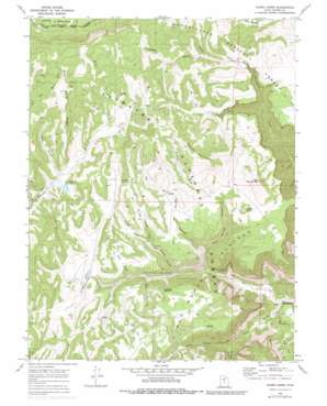
Acord Lakes Topo Map Utah
To zoom in, hover over the map of Acord Lakes
USGS Topo Quad 38111h4 - 1:24,000 scale
| Topo Map Name: | Acord Lakes |
| USGS Topo Quad ID: | 38111h4 |
| Print Size: | ca. 21 1/4" wide x 27" high |
| Southeast Coordinates: | 38.875° N latitude / 111.375° W longitude |
| Map Center Coordinates: | 38.9375° N latitude / 111.4375° W longitude |
| U.S. State: | UT |
| Filename: | o38111h4.jpg |
| Download Map JPG Image: | Acord Lakes topo map 1:24,000 scale |
| Map Type: | Topographic |
| Topo Series: | 7.5´ |
| Map Scale: | 1:24,000 |
| Source of Map Images: | United States Geological Survey (USGS) |
| Alternate Map Versions: |
Acord Lakes UT 1968, updated 1972 Download PDF Buy paper map Acord Lakes UT 1968, updated 1979 Download PDF Buy paper map Acord Lakes UT 2001, updated 2004 Download PDF Buy paper map Acord Lakes UT 2011 Download PDF Buy paper map Acord Lakes UT 2014 Download PDF Buy paper map |
| FStopo: | US Forest Service topo Acord Lakes is available: Download FStopo PDF Download FStopo TIF |
1:24,000 Topo Quads surrounding Acord Lakes
> Back to 38111e1 at 1:100,000 scale
> Back to 38110a1 at 1:250,000 scale
> Back to U.S. Topo Maps home
Acord Lakes topo map: Gazetteer
Acord Lakes: Basins
The Cove elevation 2152m 7060′Acord Lakes: Capes
Jolly Mill Point elevation 2506m 8221′Acord Lakes: Dams
Skutumpah Dam elevation 2409m 7903′Acord Lakes: Lakes
Acord Lakes elevation 2425m 7956′Acord Lakes: Mines
Convulsion Coal Mine elevation 2300m 7545′Acord Lakes: Pillars
Jack Adley Monument elevation 2567m 8421′Acord Lakes: Reservoirs
Skutumpah Reservoir elevation 2409m 7903′Acord Lakes: Ridges
Big Ridge elevation 2749m 9019′Snow Corral Ridge elevation 2771m 9091′
Acord Lakes: Springs
Anderson Spring elevation 2779m 9117′Duncan Draw Spring elevation 2705m 8874′
Fairy Spring elevation 2767m 9078′
Lizonbee Springs elevation 2504m 8215′
Lower Horse Hollow Spring elevation 2612m 8569′
Mud Spring elevation 2531m 8303′
Skutumpah Spring elevation 2560m 8398′
Upper Horse Hollow Spring elevation 2721m 8927′
Acord Lakes: Streams
South Fork North Fork Quitchupah Creek elevation 2321m 7614′Acord Lakes: Summits
Corral Knoll elevation 2649m 8690′Duncan Mountain elevation 2809m 9215′
Little Duncan Mountain elevation 2748m 9015′
Acord Lakes: Valleys
Broad Hollow elevation 2296m 7532′Collier Hollow elevation 2380m 7808′
Convulsion Canyon elevation 2011m 6597′
Duncan Draw elevation 2510m 8234′
East Spring Canyon elevation 2216m 7270′
Eldridge Hollow elevation 2429m 7969′
Horse Hollow elevation 2477m 8126′
Jolly Mill Hollow elevation 2352m 7716′
Mud Spring Hollow elevation 2300m 7545′
North Water Hollow elevation 2153m 7063′
Pin Hollow elevation 2427m 7962′
Road Hollow elevation 2415m 7923′
South Water Hollow elevation 2150m 7053′
Water Hollow elevation 2011m 6597′
Acord Lakes digital topo map on disk
Buy this Acord Lakes topo map showing relief, roads, GPS coordinates and other geographical features, as a high-resolution digital map file on DVD:


