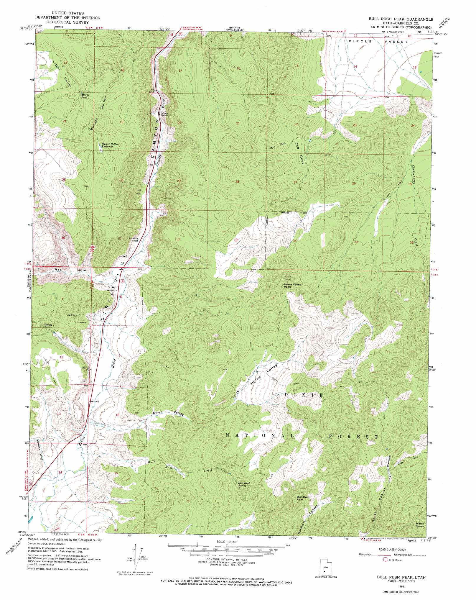
Bull Rush Peak Topo Map Utah
To zoom in, hover over the map of Bull Rush Peak
USGS Topo Quad 38112a3 - 1:24,000 scale
| Topo Map Name: | Bull Rush Peak |
| USGS Topo Quad ID: | 38112a3 |
| Print Size: | ca. 21 1/4" wide x 27" high |
| Southeast Coordinates: | 38° N latitude / 112.25° W longitude |
| Map Center Coordinates: | 38.0625° N latitude / 112.3125° W longitude |
| U.S. State: | UT |
| Filename: | o38112a3.jpg |
| Download Map JPG Image: | Bull Rush Peak topo map 1:24,000 scale |
| Map Type: | Topographic |
| Topo Series: | 7.5´ |
| Map Scale: | 1:24,000 |
| Source of Map Images: | United States Geological Survey (USGS) |
| Alternate Map Versions: |
Bull Rush Peak UT 1966, updated 1968 Download PDF Buy paper map Bull Rush Peak UT 2011 Download PDF Buy paper map Bull Rush Peak UT 2014 Download PDF Buy paper map |
| FStopo: | US Forest Service topo Bull Rush Peak is available: Download FStopo PDF Download FStopo TIF |
1:24,000 Topo Quads surrounding Bull Rush Peak
Beaver Se |
Shelly Baldy Peak |
Delano Peak |
Piute Reservoir |
Malmsten Peak |
Kane Canyon |
Circleville Mountain |
Circleville |
Junction |
Phonolite Hill |
Burnt Peak |
Fremont Pass |
Bull Rush Peak |
Mount Dutton |
Deep Creek |
Little Creek Peak |
Panguitch Nw |
Blind Spring Mountain |
Adams Head |
Cow Creek |
Fivemile Ridge |
Panguitch |
Casto Canyon |
Flake Mountain West |
Flake Mountain East |
> Back to 38112a1 at 1:100,000 scale
> Back to 38112a1 at 1:250,000 scale
> Back to U.S. Topo Maps home
Bull Rush Peak topo map: Gazetteer
Bull Rush Peak: Basins
Little Valley elevation 2224m 7296′Bull Rush Peak: Cliffs
Snowbank elevation 2786m 9140′Bull Rush Peak: Lakes
Marks Pond elevation 2169m 7116′Bull Rush Peak: Populated Places
Spry elevation 1935m 6348′Bull Rush Peak: Reservoirs
Bucket Hollow Reservoir elevation 2217m 7273′Bull Rush Peak: Springs
Bull Rush Spring elevation 2303m 7555′Indian Spring elevation 2742m 8996′
Bull Rush Peak: Streams
Bull Rush Creek elevation 1932m 6338′Chokecherry Creek elevation 2054m 6738′
Miry Creek elevation 1934m 6345′
Bull Rush Peak: Summits
Bull Rush Peak elevation 2859m 9379′Horse Valley Peak elevation 2594m 8510′
Bull Rush Peak: Valleys
Bucket Hollow elevation 1968m 6456′Hawkins Canyon elevation 1945m 6381′
Hell Hole elevation 1936m 6351′
Horse Valley elevation 2218m 7276′
Horse Valley elevation 1929m 6328′
The Cove elevation 2044m 6706′
Bull Rush Peak digital topo map on disk
Buy this Bull Rush Peak topo map showing relief, roads, GPS coordinates and other geographical features, as a high-resolution digital map file on DVD: