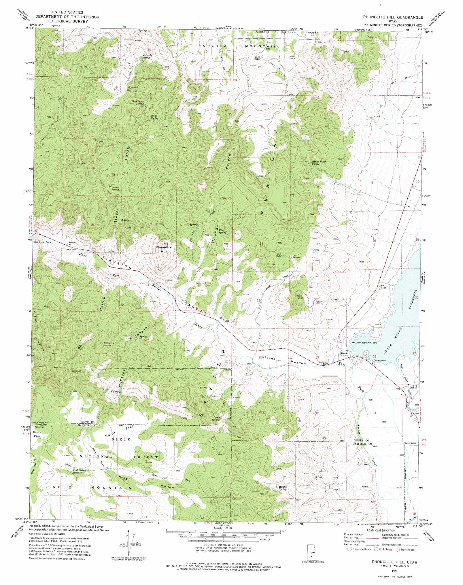
Phonolite Hill Topo Map Utah
To zoom in, hover over the map of Phonolite Hill
USGS Topo Quad 38112b1 - 1:24,000 scale
| Topo Map Name: | Phonolite Hill |
| USGS Topo Quad ID: | 38112b1 |
| Print Size: | ca. 21 1/4" wide x 27" high |
| Southeast Coordinates: | 38.125° N latitude / 112° W longitude |
| Map Center Coordinates: | 38.1875° N latitude / 112.0625° W longitude |
| U.S. State: | UT |
| Filename: | o38112b1.jpg |
| Download Map JPG Image: | Phonolite Hill topo map 1:24,000 scale |
| Map Type: | Topographic |
| Topo Series: | 7.5´ |
| Map Scale: | 1:24,000 |
| Source of Map Images: | United States Geological Survey (USGS) |
| Alternate Map Versions: |
Phonolite Hill UT 1971, updated 1974 Download PDF Buy paper map Phonolite Hill UT 2002, updated 2005 Download PDF Buy paper map Phonolite Hill UT 2011 Download PDF Buy paper map Phonolite Hill UT 2014 Download PDF Buy paper map |
| FStopo: | US Forest Service topo Phonolite Hill is available: Download FStopo PDF Download FStopo TIF |
1:24,000 Topo Quads surrounding Phonolite Hill
Mount Brigham |
Marysvale |
Marysvale Peak |
Greenwich |
Abes Knoll |
Delano Peak |
Piute Reservoir |
Malmsten Peak |
Parker Knoll |
Jakes Knoll |
Circleville |
Junction |
Phonolite Hill |
Angle |
Flossie Knoll |
Bull Rush Peak |
Mount Dutton |
Deep Creek |
Antimony |
Pollywog Lake |
Blind Spring Mountain |
Adams Head |
Cow Creek |
Grass Lakes |
Barker Reservoir |
> Back to 38112a1 at 1:100,000 scale
> Back to 38112a1 at 1:250,000 scale
> Back to U.S. Topo Maps home
Phonolite Hill topo map: Gazetteer
Phonolite Hill: Dams
Otter Creek Dam elevation 1942m 6371′Phonolite Hill: Flats
Bear Flat elevation 2916m 9566′Corral Flat elevation 2903m 9524′
Sand Flat elevation 2677m 8782′
Steens Meadow elevation 1934m 6345′
Phonolite Hill: Parks
Fishermans Bench Recreation Site elevation 1952m 6404′Otter Creek State Park elevation 1944m 6377′
Phonolite Hill: Reservoirs
Corral Flat Reservoir elevation 2876m 9435′Otter Creek Reservoir elevation 1939m 6361′
Road Hollow Reservoir elevation 2785m 9137′
Phonolite Hill: Springs
Birch Spring elevation 2219m 7280′Black Springs elevation 2246m 7368′
Blind Spring elevation 2304m 7559′
Blood Mine Spring elevation 2338m 7670′
Bullberry Spring elevation 2250m 7381′
Dripping Spring elevation 2096m 6876′
Hodge Ranch Spring elevation 2241m 7352′
Hunter Spring elevation 2122m 6961′
King Spring elevation 2097m 6879′
McCardy Spring elevation 2560m 8398′
V Spring elevation 2474m 8116′
Phonolite Hill: Summits
Lion Rock elevation 1968m 6456′Phonolite Hill elevation 2394m 7854′
Phonolite Hill: Valleys
Hickman Canyon elevation 1952m 6404′Log Hollow elevation 1916m 6286′
McCardy Canyon elevation 1933m 6341′
Road Hollow elevation 2013m 6604′
Steens Canyon elevation 1946m 6384′
Phonolite Hill digital topo map on disk
Buy this Phonolite Hill topo map showing relief, roads, GPS coordinates and other geographical features, as a high-resolution digital map file on DVD: