Kane Canyon Topo Map Utah
To zoom in, hover over the map of Kane Canyon
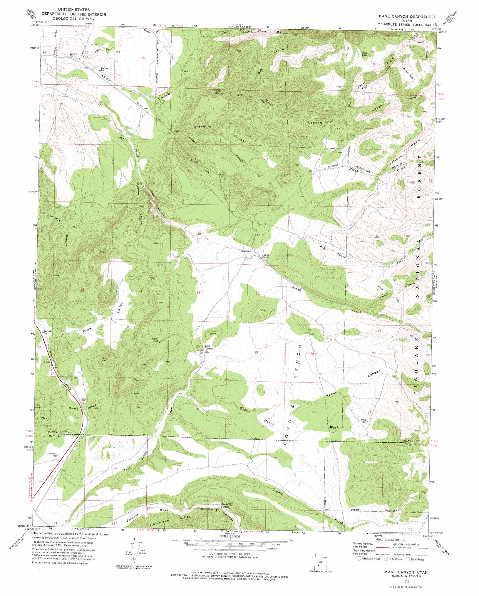
USGS Topo Quad 38112b5 - 1:24,000 scale
| Topo Map Name: | Kane Canyon |
| USGS Topo Quad ID: | 38112b5 |
| Print Size: | ca. 21 1/4" wide x 27" high |
| Southeast Coordinates: | 38.125° N latitude / 112.5° W longitude |
| Map Center Coordinates: | 38.1875° N latitude / 112.5625° W longitude |
| U.S. State: | UT |
| Filename: | o38112b5.jpg |
| Download Map JPG Image: | Kane Canyon topo map 1:24,000 scale |
| Map Type: | Topographic |
| Topo Series: | 7.5´ |
| Map Scale: | 1:24,000 |
| Source of Map Images: | United States Geological Survey (USGS) |
| Alternate Map Versions: |
Kane Canyon UT 1971, updated 1975 Download PDF Buy paper map Kane Canyon UT 2001, updated 2003 Download PDF Buy paper map Kane Canyon UT 2011 Download PDF Buy paper map Kane Canyon UT 2014 Download PDF Buy paper map |
| FStopo: | US Forest Service topo Kane Canyon is available: Download FStopo PDF Download FStopo TIF |
1:24,000 Topo Quads surrounding Kane Canyon
Bearskin Mountain |
Gillies Hill |
Pole Mountain |
Mount Belknap |
Mount Brigham |
Adamsville |
Beaver |
Beaver Se |
Shelly Baldy Peak |
Delano Peak |
Minersville Reservoir |
Greenville Bench |
Kane Canyon |
Circleville Mountain |
Circleville |
Jack Henry Knoll |
Buckhorn Flat |
Burnt Peak |
Fremont Pass |
Bull Rush Peak |
Paragonah |
Cottonwood Mountain |
Little Creek Peak |
Panguitch Nw |
Blind Spring Mountain |
> Back to 38112a1 at 1:100,000 scale
> Back to 38112a1 at 1:250,000 scale
> Back to U.S. Topo Maps home
Kane Canyon topo map: Gazetteer
Kane Canyon: Benches
Coyote Bench elevation 2140m 7020′Kane Canyon: Flats
Horse Flat elevation 2462m 8077′Porkies Pasture elevation 2564m 8412′
Kane Canyon: Lakes
Mud Lake elevation 2439m 8001′Kane Canyon: Ridges
Beaver Ridge elevation 1997m 6551′Kane Canyon: Springs
Kane Spring elevation 2020m 6627′Lees Spring elevation 2059m 6755′
Sand Cliff Spring elevation 1987m 6519′
Kane Canyon: Streams
Big Twist Creek elevation 2084m 6837′Birch Creek elevation 1888m 6194′
Chalk Creek elevation 2204m 7230′
Coyote Creek elevation 1972m 6469′
Rocky Creek elevation 2036m 6679′
Kane Canyon: Trails
Copes Dugway elevation 2536m 8320′Kane Canyon: Valleys
Blue Valley elevation 1953m 6407′Boulder Canyon elevation 1915m 6282′
Chalk Hollow elevation 2208m 7244′
Fremont Canyon elevation 1974m 6476′
Kane Canyon elevation 1828m 5997′
North Fork Kane Canyon elevation 2215m 7267′
Patterson Hollow elevation 2298m 7539′
Pot Gut elevation 1977m 6486′
Rocky Canyon elevation 2082m 6830′
Scrabble Canyon elevation 1902m 6240′
South Fork Kane Canyon elevation 2217m 7273′
The Narrows elevation 1935m 6348′
Wet Hollow elevation 2066m 6778′
Wide Mouth Wash elevation 2016m 6614′
Kane Canyon digital topo map on disk
Buy this Kane Canyon topo map showing relief, roads, GPS coordinates and other geographical features, as a high-resolution digital map file on DVD: