Adamsville Topo Map Utah
To zoom in, hover over the map of Adamsville
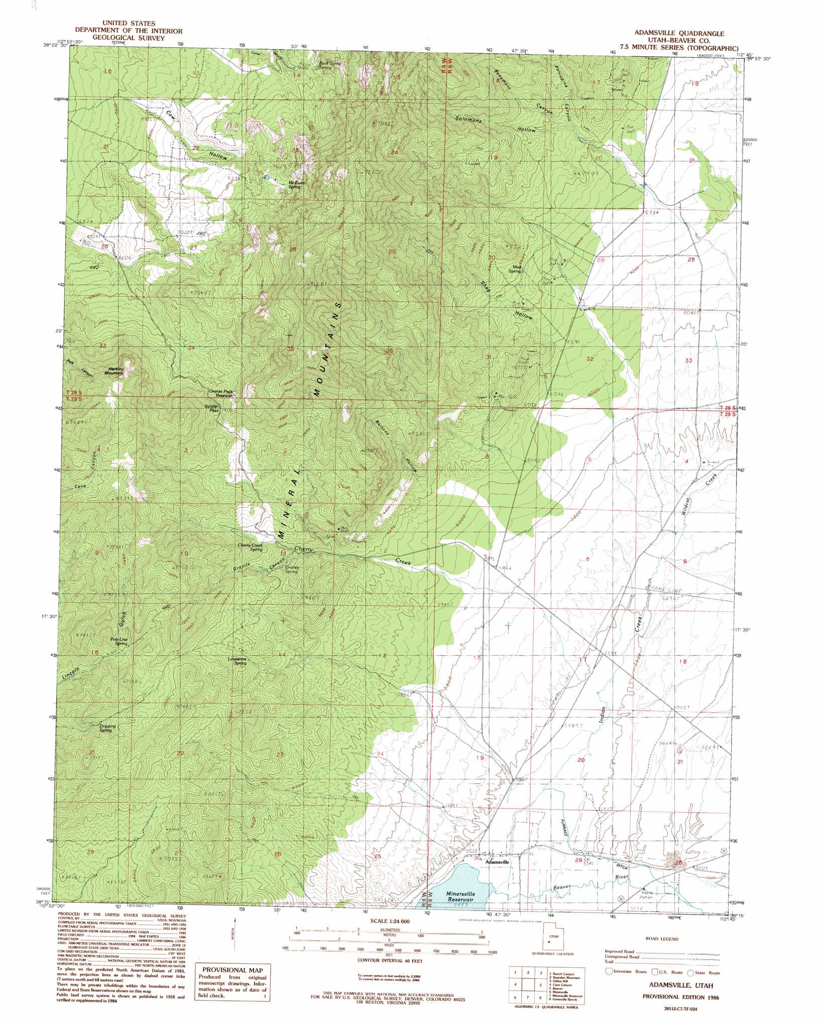
USGS Topo Quad 38112c7 - 1:24,000 scale
| Topo Map Name: | Adamsville |
| USGS Topo Quad ID: | 38112c7 |
| Print Size: | ca. 21 1/4" wide x 27" high |
| Southeast Coordinates: | 38.25° N latitude / 112.75° W longitude |
| Map Center Coordinates: | 38.3125° N latitude / 112.8125° W longitude |
| U.S. State: | UT |
| Filename: | o38112c7.jpg |
| Download Map JPG Image: | Adamsville topo map 1:24,000 scale |
| Map Type: | Topographic |
| Topo Series: | 7.5´ |
| Map Scale: | 1:24,000 |
| Source of Map Images: | United States Geological Survey (USGS) |
| Alternate Map Versions: |
Adamsville UT 1986, updated 1986 Download PDF Buy paper map Adamsville UT 2010 Download PDF Buy paper map Adamsville UT 2014 Download PDF Buy paper map |
1:24,000 Topo Quads surrounding Adamsville
Lime Mountain |
Read |
Pinnacle Pass |
Cinder Crater |
Cove Fort |
Milford |
Ranch Canyon |
Bearskin Mountain |
Gillies Hill |
Pole Mountain |
Milford Flat |
Cave Canyon |
Adamsville |
Beaver |
Beaver Se |
Ninemile Knoll |
Minersville |
Minersville Reservoir |
Greenville Bench |
Kane Canyon |
Baboon Peak |
Dry Willow Peak |
Jack Henry Knoll |
Buckhorn Flat |
Burnt Peak |
> Back to 38112a1 at 1:100,000 scale
> Back to 38112a1 at 1:250,000 scale
> Back to U.S. Topo Maps home
Adamsville topo map: Gazetteer
Adamsville: Canals
Furnace Ditch elevation 1693m 5554′Adamsville: Gaps
Soldier Pass elevation 2291m 7516′Adamsville: Mines
Beaver View Mine elevation 1998m 6555′Blue Star Mine elevation 2052m 6732′
Adamsville: Parks
Rock Corral Recreation Site elevation 2134m 7001′Adamsville: Populated Places
Adamsville elevation 1685m 5528′Adamsville: Ranges
Mineral Mountains elevation 2663m 8736′Adamsville: Reservoirs
Granite Peak Reservoir elevation 2265m 7431′Adamsville: Springs
Cherry Creek Spring elevation 2045m 6709′Dripping Spring elevation 2084m 6837′
Granite Spring elevation 2014m 6607′
Limestone Spring elevation 2044m 6706′
McEwen Spring elevation 2236m 7335′
Mud Spring elevation 2031m 6663′
Pole Line Spring elevation 2131m 6991′
Rock Corral Spring elevation 2164m 7099′
Adamsville: Streams
Cherry Creek elevation 1712m 5616′Indian Creek elevation 1676m 5498′
Wildcat Creek elevation 1719m 5639′
Adamsville: Summits
Harkley Mountain elevation 2502m 8208′Adamsville: Valleys
Bartons Hollow elevation 1939m 6361′Beaumont Canyon elevation 2094m 6870′
Cow Hollow elevation 2041m 6696′
Granite Canyon elevation 2065m 6774′
Porcupine Canyon elevation 2062m 6765′
Shag Hollow elevation 1907m 6256′
Solomons Hollow elevation 2057m 6748′
Adamsville digital topo map on disk
Buy this Adamsville topo map showing relief, roads, GPS coordinates and other geographical features, as a high-resolution digital map file on DVD: