Pole Mountain Topo Map Utah
To zoom in, hover over the map of Pole Mountain
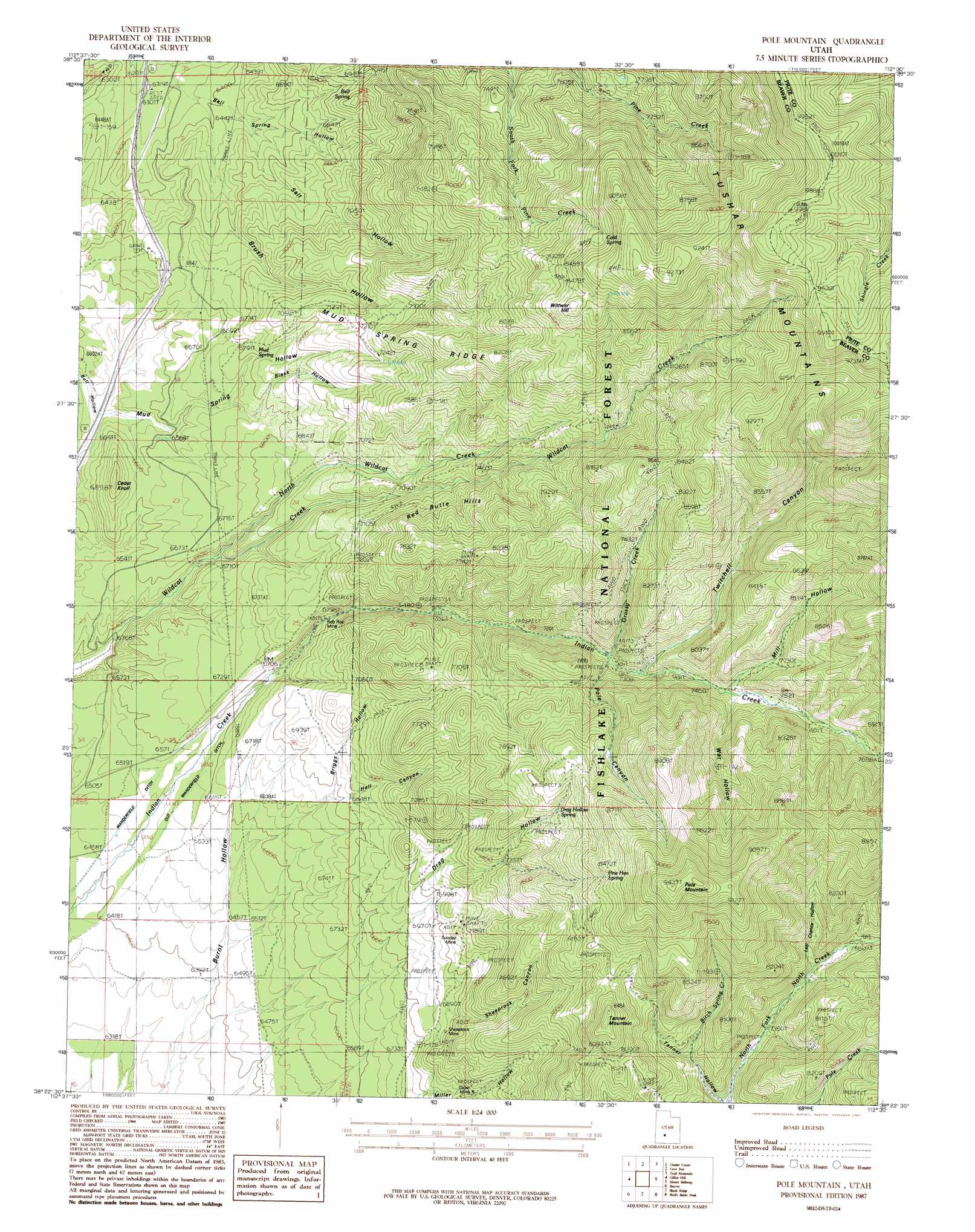
USGS Topo Quad 38112d5 - 1:24,000 scale
| Topo Map Name: | Pole Mountain |
| USGS Topo Quad ID: | 38112d5 |
| Print Size: | ca. 21 1/4" wide x 27" high |
| Southeast Coordinates: | 38.375° N latitude / 112.5° W longitude |
| Map Center Coordinates: | 38.4375° N latitude / 112.5625° W longitude |
| U.S. State: | UT |
| Filename: | o38112d5.jpg |
| Download Map JPG Image: | Pole Mountain topo map 1:24,000 scale |
| Map Type: | Topographic |
| Topo Series: | 7.5´ |
| Map Scale: | 1:24,000 |
| Source of Map Images: | United States Geological Survey (USGS) |
| Alternate Map Versions: |
Beaver NE UT 1954, updated 1955 Download PDF Buy paper map Pole Mountain UT 1987, updated 1987 Download PDF Buy paper map Pole Mountain UT 2001, updated 2003 Download PDF Buy paper map Pole Mountain UT 2011 Download PDF Buy paper map Pole Mountain UT 2014 Download PDF Buy paper map |
| FStopo: | US Forest Service topo Pole Mountain is available: Download FStopo PDF Download FStopo TIF |
1:24,000 Topo Quads surrounding Pole Mountain
Antelope Spring |
Antelope Valley |
Dog Valley Peak |
Red Ridge |
Joseph Peak |
Pinnacle Pass |
Cinder Crater |
Cove Fort |
Trail Mountain |
Marysvale Canyon |
Bearskin Mountain |
Gillies Hill |
Pole Mountain |
Mount Belknap |
Mount Brigham |
Adamsville |
Beaver |
Beaver Se |
Shelly Baldy Peak |
Delano Peak |
Minersville Reservoir |
Greenville Bench |
Kane Canyon |
Circleville Mountain |
Circleville |
> Back to 38112a1 at 1:100,000 scale
> Back to 38112a1 at 1:250,000 scale
> Back to U.S. Topo Maps home
Pole Mountain topo map: Gazetteer
Pole Mountain: Canals
Manderfield Ditch elevation 1989m 6525′Old Manderfield Ditch elevation 1978m 6489′
Pole Mountain: Mines
Glider Mine elevation 2149m 7050′Rob Roy Mine elevation 2064m 6771′
Sheeprock Mine elevation 2133m 6998′
Sunday Mine elevation 2183m 7162′
White Cliff Mine elevation 2216m 7270′
White Cliff Mine (historical) elevation 2193m 7194′
Pole Mountain: Ridges
Mud Spring Ridge elevation 2502m 8208′Red Butte Hills elevation 2268m 7440′
Pole Mountain: Springs
Bell Spring elevation 2095m 6873′Cold Spring elevation 2523m 8277′
Drag Hollow Spring elevation 2394m 7854′
Drag Hollow Spring elevation 2395m 7857′
Mud Spring elevation 2079m 6820′
Pine Hen Spring elevation 2517m 8257′
Pole Mountain: Streams
Birch Spring Creek elevation 2205m 7234′Grassy Creek elevation 2228m 7309′
North Wildcat Creek elevation 2011m 6597′
Pole Mountain: Summits
Cedar Knoll elevation 2101m 6893′Pole Mountain elevation 2870m 9416′
Tanner Mountain elevation 2584m 8477′
Wittwer Hill elevation 2651m 8697′
Pole Mountain: Valleys
Bell Spring Hollow elevation 1960m 6430′Black Hollow elevation 2057m 6748′
Briggs Hollow elevation 2100m 6889′
Brush Hollow elevation 1959m 6427′
Drag Hollow elevation 2118m 6948′
Hell Canyon elevation 2090m 6856′
Last Chance Hollow elevation 2297m 7536′
Mill Hollow elevation 2301m 7549′
Pole Canyon elevation 2248m 7375′
Salt Hollow elevation 1977m 6486′
Sheeprock Canyon elevation 2140m 7020′
Tanner Hollow elevation 2295m 7529′
Twitchell Canyon elevation 2258m 7408′
Wet Hollow elevation 2285m 7496′
Pole Mountain digital topo map on disk
Buy this Pole Mountain topo map showing relief, roads, GPS coordinates and other geographical features, as a high-resolution digital map file on DVD: