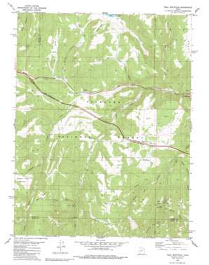
Trail Mountain Topo Map Utah
To zoom in, hover over the map of Trail Mountain
USGS Topo Quad 38112e4 - 1:24,000 scale
| Topo Map Name: | Trail Mountain |
| USGS Topo Quad ID: | 38112e4 |
| Print Size: | ca. 21 1/4" wide x 27" high |
| Southeast Coordinates: | 38.5° N latitude / 112.375° W longitude |
| Map Center Coordinates: | 38.5625° N latitude / 112.4375° W longitude |
| U.S. State: | UT |
| Filename: | o38112e4.jpg |
| Download Map JPG Image: | Trail Mountain topo map 1:24,000 scale |
| Map Type: | Topographic |
| Topo Series: | 7.5´ |
| Map Scale: | 1:24,000 |
| Source of Map Images: | United States Geological Survey (USGS) |
| Alternate Map Versions: |
Trail Mountain UT 1981, updated 1981 Download PDF Buy paper map Trail Mountain UT 1981, updated 1991 Download PDF Buy paper map Trail Mountain UT 2001, updated 2003 Download PDF Buy paper map Trail Mountain UT 2011 Download PDF Buy paper map Trail Mountain UT 2014 Download PDF Buy paper map |
| FStopo: | US Forest Service topo Trail Mountain is available: Download FStopo PDF Download FStopo TIF |
1:24,000 Topo Quads surrounding Trail Mountain
> Back to 38112e1 at 1:100,000 scale
> Back to 38112a1 at 1:250,000 scale
> Back to U.S. Topo Maps home
Trail Mountain topo map: Gazetteer
Trail Mountain: Benches
Sawmill Bench elevation 2547m 8356′Trail Mountain: Flats
Devils Dance Floor elevation 2201m 7221′Mud Flats elevation 2061m 6761′
Oak Flat elevation 2351m 7713′
Shingle Creek Meadows elevation 2613m 8572′
Trail Mountain: Gaps
The Narrows elevation 1841m 6040′Trail Mountain: Ridges
Rattlesnake Ridge elevation 2500m 8202′Whiterock Hump elevation 2378m 7801′
Trail Mountain: Springs
Maple Spring elevation 2412m 7913′Mud Spring elevation 2111m 6925′
Trail Mountain: Streams
Coldwater Creek elevation 2276m 7467′Fish Creek elevation 1892m 6207′
Pole Creek elevation 1861m 6105′
Rosebud Creek elevation 2112m 6929′
Serviceberry Creek elevation 2071m 6794′
Shingle Creek elevation 2001m 6564′
Shingle Creek elevation 1999m 6558′
Three Creeks elevation 1929m 6328′
Trail Mountain: Summits
Trail Mountain elevation 2090m 6856′Trail Mountain: Valleys
Long Valley elevation 2082m 6830′Maple Spring Hollow elevation 2015m 6610′
Mud Spring Hollow elevation 2059m 6755′
Oak Spring Hollow elevation 2220m 7283′
Red Narrows elevation 2084m 6837′
Sevier Canyon elevation 2029m 6656′
Snow Canyon elevation 2098m 6883′
Trail Mountain Hollow elevation 1952m 6404′
Trail Mountain: Woods
North Cedars elevation 2127m 6978′Trail Mountain digital topo map on disk
Buy this Trail Mountain topo map showing relief, roads, GPS coordinates and other geographical features, as a high-resolution digital map file on DVD:


