Rice Mountain Topo Map Nevada
To zoom in, hover over the map of Rice Mountain
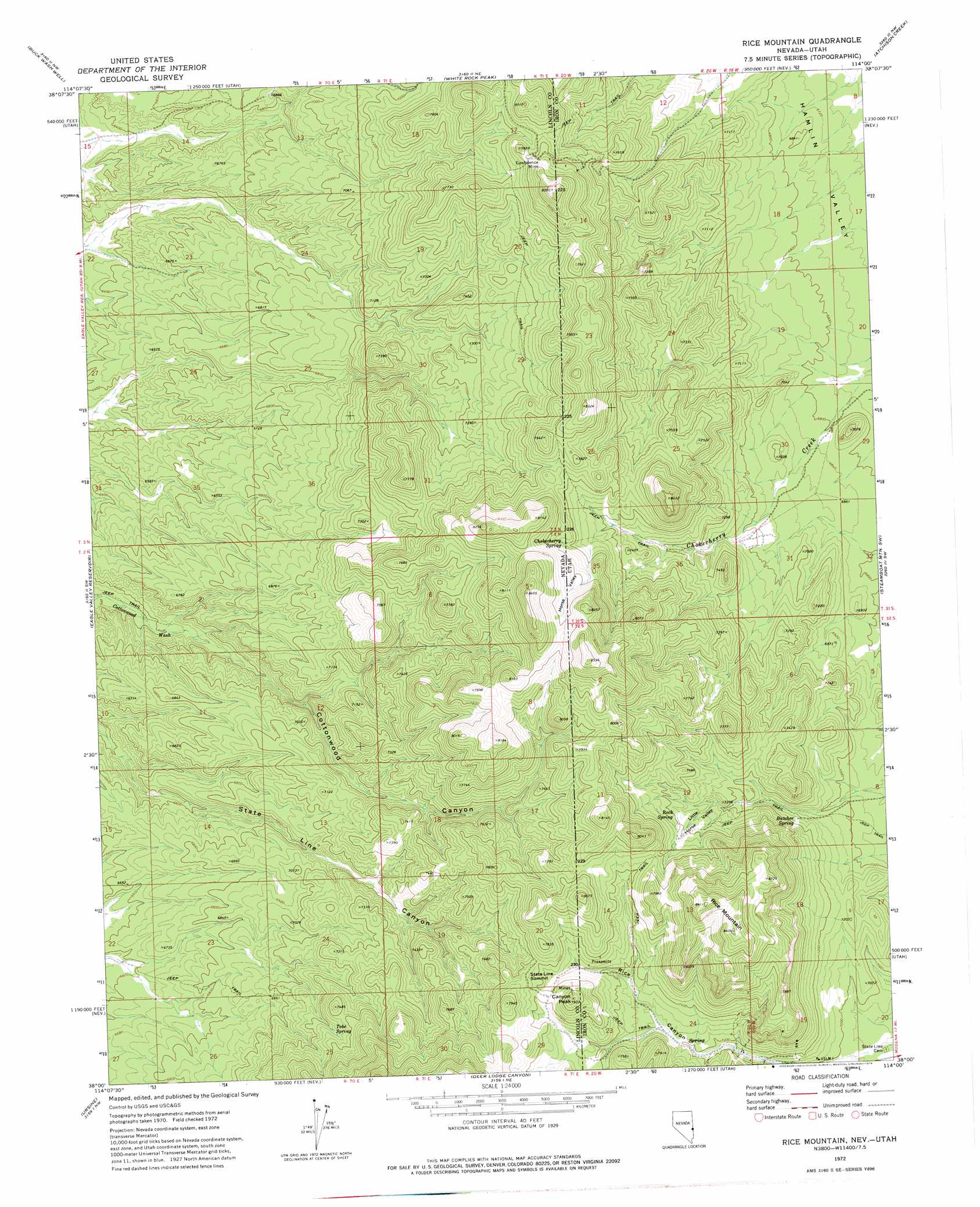
USGS Topo Quad 38114a1 - 1:24,000 scale
| Topo Map Name: | Rice Mountain |
| USGS Topo Quad ID: | 38114a1 |
| Print Size: | ca. 21 1/4" wide x 27" high |
| Southeast Coordinates: | 38° N latitude / 114° W longitude |
| Map Center Coordinates: | 38.0625° N latitude / 114.0625° W longitude |
| U.S. States: | NV, UT |
| Filename: | o38114a1.jpg |
| Download Map JPG Image: | Rice Mountain topo map 1:24,000 scale |
| Map Type: | Topographic |
| Topo Series: | 7.5´ |
| Map Scale: | 1:24,000 |
| Source of Map Images: | United States Geological Survey (USGS) |
| Alternate Map Versions: |
Rice Mountain UT 1972, updated 1974 Download PDF Buy paper map Rice Mountain UT 2011 Download PDF Buy paper map Rice Mountain UT 2014 Download PDF Buy paper map Rice Mountain UT 2017 Download PDF Buy paper map |
1:24,000 Topo Quads surrounding Rice Mountain
Trail Canyon |
Miller Canyon |
Gleason Basin |
Miners Cabin Wash |
Buckhorn Spring |
Parsnip Peak |
Buck Wash Well |
White Rock Peak |
Atchison Creek |
Pinto Spring |
Pierson Summit |
Eagle Valley Reservoir |
Rice Mountain |
Steamboat Mountain Sw |
Steamboat Mountain |
Rose Valley |
Ursine |
Deer Lodge Canyon |
Eightmile Spring |
Bannion Spring |
Condor Canyon |
Panaca Summit |
Prohibition Flat |
Modena |
Heist |
> Back to 38114a1 at 1:100,000 scale
> Back to 38114a1 at 1:250,000 scale
> Back to U.S. Topo Maps home
Rice Mountain topo map: Gazetteer
Rice Mountain: Gaps
State Line Summit elevation 2340m 7677′Rice Mountain: Mines
Confidence Mine elevation 2388m 7834′Rice Mountain: Ranges
Needle Mountains elevation 2457m 8061′Needle Mountains elevation 2471m 8106′
Rice Mountain: Springs
Butcher Spring elevation 2183m 7162′Chokecherry Spring elevation 2332m 7650′
Rock Spring elevation 2252m 7388′
Tobe Spring elevation 2215m 7267′
Rice Mountain: Summits
Canyon Peak elevation 2418m 7933′Rice Mountain elevation 2563m 8408′
Rice Mountain: Valleys
Cottonwood Canyon elevation 1977m 6486′Horse Valley elevation 2247m 7372′
Horse Valley elevation 2245m 7365′
Little Horse Valley elevation 2204m 7230′
Rice Mountain digital topo map on disk
Buy this Rice Mountain topo map showing relief, roads, GPS coordinates and other geographical features, as a high-resolution digital map file on DVD: