Shingle Pass Se Topo Map Nevada
To zoom in, hover over the map of Shingle Pass Se
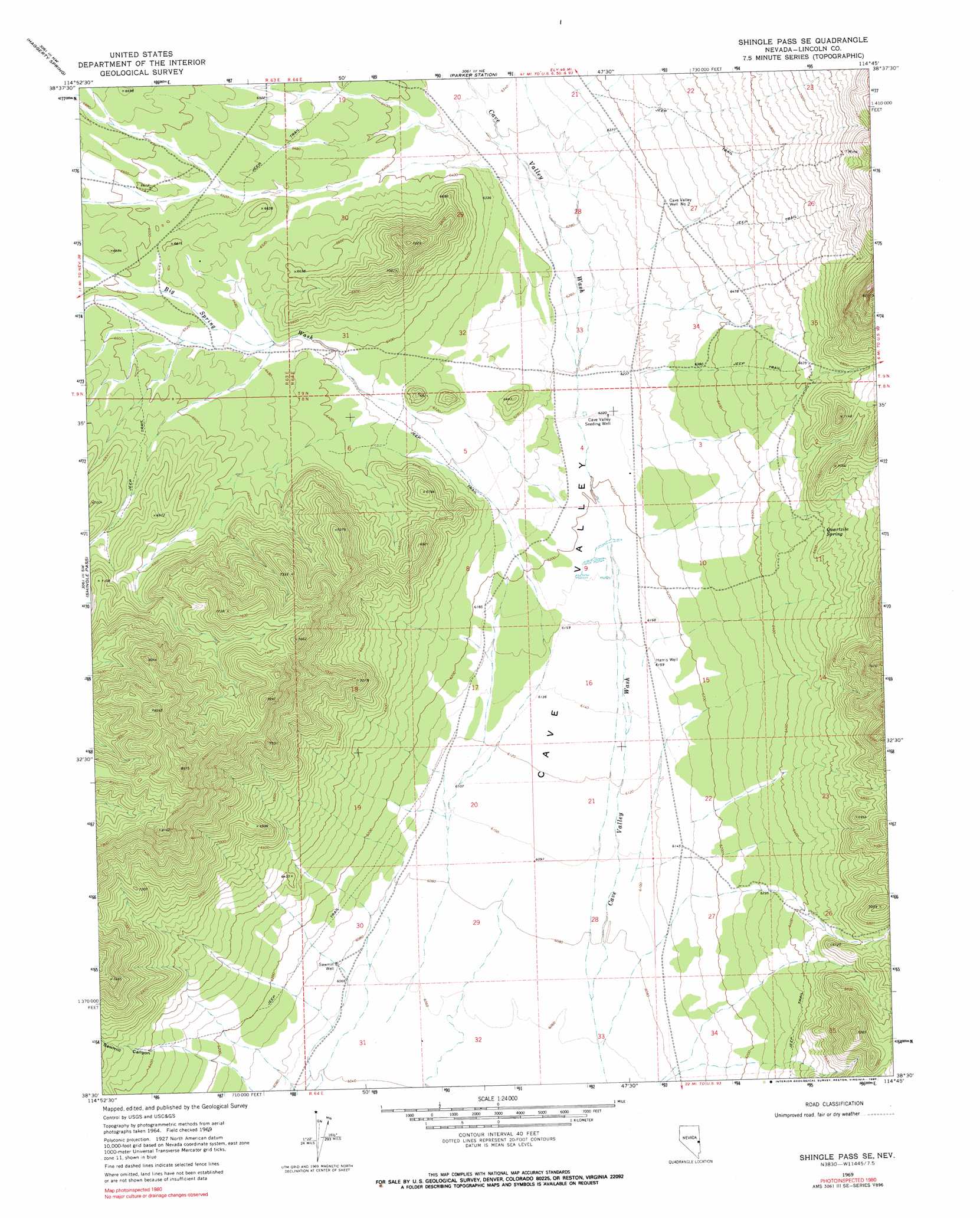
USGS Topo Quad 38114e7 - 1:24,000 scale
| Topo Map Name: | Shingle Pass Se |
| USGS Topo Quad ID: | 38114e7 |
| Print Size: | ca. 21 1/4" wide x 27" high |
| Southeast Coordinates: | 38.5° N latitude / 114.75° W longitude |
| Map Center Coordinates: | 38.5625° N latitude / 114.8125° W longitude |
| U.S. State: | NV |
| Filename: | o38114e7.jpg |
| Download Map JPG Image: | Shingle Pass Se topo map 1:24,000 scale |
| Map Type: | Topographic |
| Topo Series: | 7.5´ |
| Map Scale: | 1:24,000 |
| Source of Map Images: | United States Geological Survey (USGS) |
| Alternate Map Versions: |
Shingle Pass SE NV 1969, updated 1971 Download PDF Buy paper map Shingle Pass SE NV 1969, updated 1990 Download PDF Buy paper map Shingle Pass SE NV 2012 Download PDF Buy paper map Shingle Pass SE NV 2015 Download PDF Buy paper map |
1:24,000 Topo Quads surrounding Shingle Pass Se
Lund |
Brown Knoll |
Bullwhack Summit |
Cattle Camp Spring |
Lake Valley Summit |
Hardy Springs |
Haggerty Spring |
Parker Station |
Mount Grafton |
Mount Grafton Ne |
Moorman Spring Se |
Shingle Pass |
Shingle Pass Se |
Milk Ranch Spring |
Gouge Eye Well |
Sunnyside |
Cave Valley Well |
Sidehill Spring |
Dutch John Mountain |
Mustang Well |
Gap Mountain |
Silver King Well |
Sidehill Pass |
Grassy Mountain |
Pony Springs |
> Back to 38114e1 at 1:100,000 scale
> Back to 38114a1 at 1:250,000 scale
> Back to U.S. Topo Maps home
Shingle Pass Se topo map: Gazetteer
Shingle Pass Se: Mines
Eagle Rock Mine elevation 2219m 7280′Shingle Pass Se: Springs
Quartzite Spring elevation 2017m 6617′Shingle Pass Se: Streams
Big Spring Wash elevation 1846m 6056′Shingle Pass Se: Valleys
Sawmill Canyon elevation 1890m 6200′Shingle Pass Se: Wells
Cave Valley Seeding Well elevation 1897m 6223′Cave Valley Well Number Two elevation 1956m 6417′
Harris Well elevation 1879m 6164′
Sawmill Well elevation 1855m 6085′
Shingle Pass Se digital topo map on disk
Buy this Shingle Pass Se topo map showing relief, roads, GPS coordinates and other geographical features, as a high-resolution digital map file on DVD: