Sawmill Canyon Topo Map Nevada
To zoom in, hover over the map of Sawmill Canyon
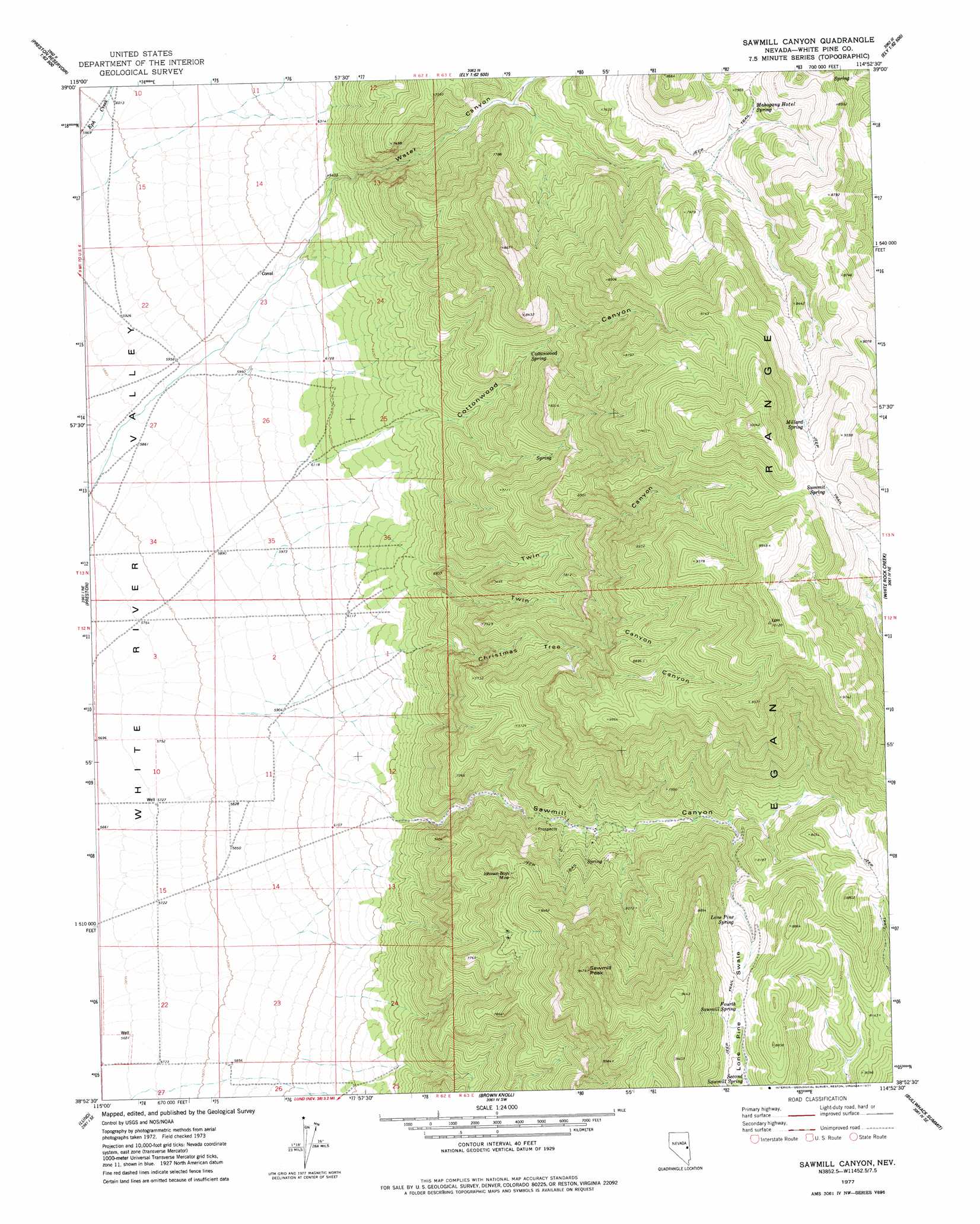
USGS Topo Quad 38114h8 - 1:24,000 scale
| Topo Map Name: | Sawmill Canyon |
| USGS Topo Quad ID: | 38114h8 |
| Print Size: | ca. 21 1/4" wide x 27" high |
| Southeast Coordinates: | 38.875° N latitude / 114.875° W longitude |
| Map Center Coordinates: | 38.9375° N latitude / 114.9375° W longitude |
| U.S. State: | NV |
| Filename: | o38114h8.jpg |
| Download Map JPG Image: | Sawmill Canyon topo map 1:24,000 scale |
| Map Type: | Topographic |
| Topo Series: | 7.5´ |
| Map Scale: | 1:24,000 |
| Source of Map Images: | United States Geological Survey (USGS) |
| Alternate Map Versions: |
Sawmill Canyon NV 1977, updated 1977 Download PDF Buy paper map Sawmill Canyon NV 2012 Download PDF Buy paper map Sawmill Canyon NV 2014 Download PDF Buy paper map |
1:24,000 Topo Quads surrounding Sawmill Canyon
Railroad Crossing Dam |
Giroux Wash |
Ely |
Comins Lake |
Cave Creek |
Blackjack Springs |
Preston Reservoir |
Ward Mountain |
Ward Charcoal Ovens |
Connors Pass |
Badger Hole Spring |
Preston |
Sawmill Canyon |
White Rock Creek |
Horse Camp Springs |
Douglas |
Lund |
Brown Knoll |
Bullwhack Summit |
Cattle Camp Spring |
Moorman Spring Nw |
Hardy Springs |
Haggerty Spring |
Parker Station |
Mount Grafton |
> Back to 38114e1 at 1:100,000 scale
> Back to 38114a1 at 1:250,000 scale
> Back to U.S. Topo Maps home
Sawmill Canyon topo map: Gazetteer
Sawmill Canyon: Mines
Ellison Mine elevation 2209m 7247′Hendrix Mine elevation 2395m 7857′
Johnson Boys Mine elevation 2389m 7837′
Sawmill Canyon: Springs
Cottonwood Spring elevation 2219m 7280′Fourth Sawmill Spring elevation 2584m 8477′
Lone Pine Spring elevation 2479m 8133′
Mahogany Hotel Spring elevation 2352m 7716′
Millard Spring elevation 2727m 8946′
Sawmill Spring elevation 2461m 8074′
Second Sawmill Spring elevation 2533m 8310′
Summit Spring elevation 2780m 9120′
Sawmill Canyon: Summits
Red Butte elevation 2638m 8654′Sawmill Peak elevation 2880m 9448′
Sawmill Canyon: Valleys
Christmas Tree Canyon elevation 1947m 6387′Cottonwood Canyon elevation 1946m 6384′
Lone Pine Swale elevation 2303m 7555′
Sawmill Canyon elevation 1918m 6292′
Twin Canyon elevation 1959m 6427′
Water Canyon elevation 1947m 6387′
Sawmill Canyon digital topo map on disk
Buy this Sawmill Canyon topo map showing relief, roads, GPS coordinates and other geographical features, as a high-resolution digital map file on DVD: