Heath Canyon Topo Map Nevada
To zoom in, hover over the map of Heath Canyon
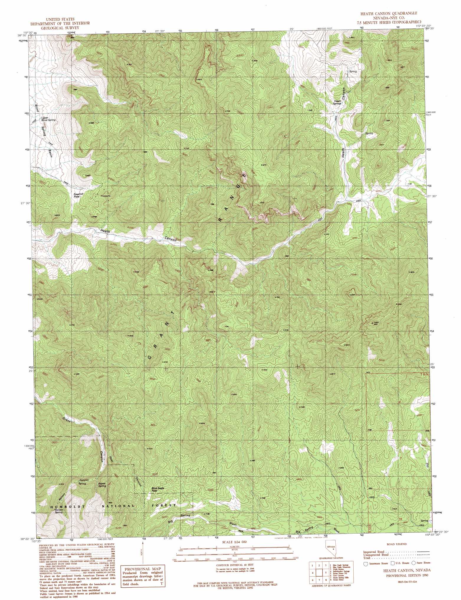
USGS Topo Quad 38115d4 - 1:24,000 scale
| Topo Map Name: | Heath Canyon |
| USGS Topo Quad ID: | 38115d4 |
| Print Size: | ca. 21 1/4" wide x 27" high |
| Southeast Coordinates: | 38.375° N latitude / 115.375° W longitude |
| Map Center Coordinates: | 38.4375° N latitude / 115.4375° W longitude |
| U.S. State: | NV |
| Filename: | o38115d4.jpg |
| Download Map JPG Image: | Heath Canyon topo map 1:24,000 scale |
| Map Type: | Topographic |
| Topo Series: | 7.5´ |
| Map Scale: | 1:24,000 |
| Source of Map Images: | United States Geological Survey (USGS) |
| Alternate Map Versions: |
Heath Canyon NV 1990, updated 1990 Download PDF Buy paper map Heath Canyon NV 2012 Download PDF Buy paper map Heath Canyon NV 2014 Download PDF Buy paper map |
| FStopo: | US Forest Service topo Heath Canyon is available: Download FStopo PDF Download FStopo TIF |
1:24,000 Topo Quads surrounding Heath Canyon
Meteorite Crater |
Blue Eagle Springs Ne |
Currant |
Callaway Well |
Moorman Spring Nw |
Blue Eagle Springs Sw |
Blue Eagle Springs |
Blue Eagle Mountain |
Wells Station |
Moorman Spring |
Christian Spring |
Bullwhacker Springs |
Heath Canyon |
Forest Home Ne |
Sunnyside Nw |
Crows Nest |
Troy Canyon |
Horse Spring Hills |
Forest Home |
Hot Creek Butte |
Nyala |
Adaven |
Water Gap Nw |
Water Gap Ne |
Timber Mountain Pass Nw |
> Back to 38115a1 at 1:100,000 scale
> Back to 38114a1 at 1:250,000 scale
> Back to U.S. Topo Maps home
Heath Canyon topo map: Gazetteer
Heath Canyon: Gaps
Blue Eagle Pass elevation 2297m 7536′Heath Canyon: Ranges
Grant Range elevation 2383m 7818′Heath Canyon: Springs
Aspen Spring elevation 2236m 7335′Balsam Spring elevation 2435m 7988′
Forest Home Spring elevation 1901m 6236′
Heath Springs elevation 2228m 7309′
Mud Spring elevation 2261m 7417′
Upper Blind Spring elevation 1694m 5557′
Heath Canyon: Valleys
Balsam Canyon elevation 2219m 7280′Post Canyon elevation 2072m 6797′
Heath Canyon digital topo map on disk
Buy this Heath Canyon topo map showing relief, roads, GPS coordinates and other geographical features, as a high-resolution digital map file on DVD: