Currant Mountain Topo Map Nevada
To zoom in, hover over the map of Currant Mountain
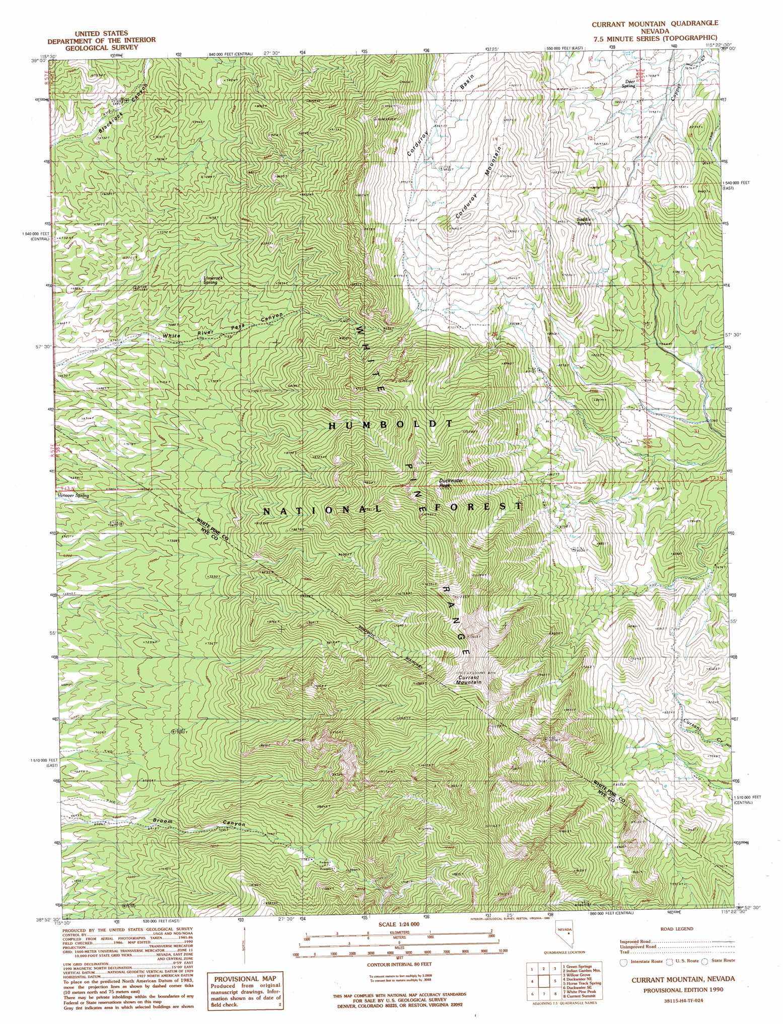
USGS Topo Quad 38115h4 - 1:24,000 scale
| Topo Map Name: | Currant Mountain |
| USGS Topo Quad ID: | 38115h4 |
| Print Size: | ca. 21 1/4" wide x 27" high |
| Southeast Coordinates: | 38.875° N latitude / 115.375° W longitude |
| Map Center Coordinates: | 38.9375° N latitude / 115.4375° W longitude |
| U.S. State: | NV |
| Filename: | o38115h4.jpg |
| Download Map JPG Image: | Currant Mountain topo map 1:24,000 scale |
| Map Type: | Topographic |
| Topo Series: | 7.5´ |
| Map Scale: | 1:24,000 |
| Source of Map Images: | United States Geological Survey (USGS) |
| Alternate Map Versions: |
Currant Mountain NV 1990, updated 1990 Download PDF Buy paper map Currant Mountain NV 2012 Download PDF Buy paper map Currant Mountain NV 2014 Download PDF Buy paper map |
| FStopo: | US Forest Service topo Currant Mountain is available: Download FStopo PDF Download FStopo TIF |
1:24,000 Topo Quads surrounding Currant Mountain
Green Springs Nw |
Mount Hamilton |
Treasure Hill |
Limestone Peak |
Railroad Crossing Dam |
Green Springs Sw |
Green Springs |
Indian Garden Mountain |
Easter Springs |
Blackjack Springs |
Duckwater |
Duckwater Ne |
Currant Mountain |
Horse Track Spring |
Badger Hole Spring |
Bradshaw Spring |
Duckwater Se |
White Pine Peak |
Currant Summit |
Douglas |
Meteorite Crater |
Blue Eagle Springs Ne |
Currant |
Callaway Well |
Moorman Spring Nw |
> Back to 38115e1 at 1:100,000 scale
> Back to 38114a1 at 1:250,000 scale
> Back to U.S. Topo Maps home
Currant Mountain topo map: Gazetteer
Currant Mountain: Basins
Corduroy Basin elevation 2672m 8766′Currant Mountain: Gaps
Beef Pass elevation 2464m 8083′Currant Mountain: Ranges
White Pine Range elevation 2738m 8982′Currant Mountain: Springs
Deer Spring elevation 2379m 7805′Limerock Spring elevation 2231m 7319′
Saddle Spring elevation 2485m 8152′
Currant Mountain: Summits
Blackrock elevation 3048m 10000′Corduroy Mountain elevation 2916m 9566′
Currant Mountain elevation 3492m 11456′
Duckwater Peak elevation 3377m 11079′
Currant Mountain digital topo map on disk
Buy this Currant Mountain topo map showing relief, roads, GPS coordinates and other geographical features, as a high-resolution digital map file on DVD: