Tybo Topo Map Nevada
To zoom in, hover over the map of Tybo
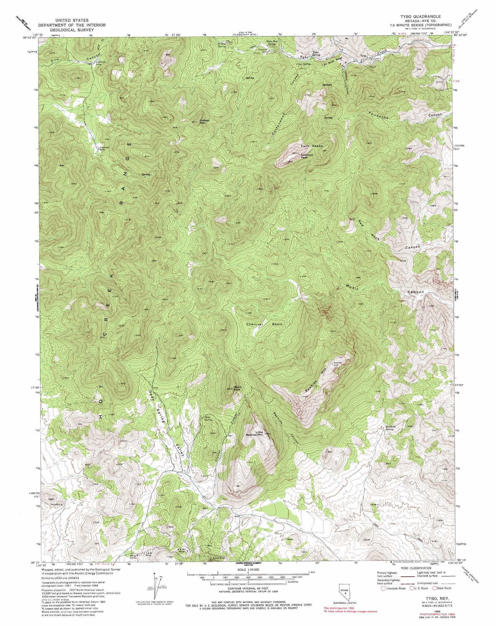
USGS Topo Quad 38116c4 - 1:24,000 scale
| Topo Map Name: | Tybo |
| USGS Topo Quad ID: | 38116c4 |
| Print Size: | ca. 21 1/4" wide x 27" high |
| Southeast Coordinates: | 38.25° N latitude / 116.375° W longitude |
| Map Center Coordinates: | 38.3125° N latitude / 116.4375° W longitude |
| U.S. State: | NV |
| Filename: | o38116c4.jpg |
| Download Map JPG Image: | Tybo topo map 1:24,000 scale |
| Map Type: | Topographic |
| Topo Series: | 7.5´ |
| Map Scale: | 1:24,000 |
| Source of Map Images: | United States Geological Survey (USGS) |
| Alternate Map Versions: |
Tybo NV 1968, updated 1973 Download PDF Buy paper map Tybo NV 1968, updated 1984 Download PDF Buy paper map Tybo NV 2012 Download PDF Buy paper map Tybo NV 2014 Download PDF Buy paper map |
1:24,000 Topo Quads surrounding Tybo
Elkhorn Canyon |
Eagle Pass |
Little Fish Lake |
Hobble Canyon |
Moores Station Sw |
Mccann Canyon |
Mcintyre Summit |
Flagstaff Mountain |
Blue Jay Spring |
Palisade Mesa |
Georges Canyon Rim |
Georges Canyon Rim Se |
Tybo |
Tybo Well |
Buckwheat Rim |
Stone Cabin Ranch |
Stone Cabin Ranch Ne |
Warm Springs Summit |
Warm Springs |
Twin Springs Slough |
Stone Cabin Ranch Sw |
Stone Cabin Ranch Se |
Bellehelen |
Warm Springs Se |
Reveille |
> Back to 38116a1 at 1:100,000 scale
> Back to 38116a1 at 1:250,000 scale
> Back to U.S. Topo Maps home
Tybo topo map: Gazetteer
Tybo: Basins
Charcoal Basin elevation 2191m 7188′Wide Valley elevation 1952m 6404′
Tybo: Mines
A and B Mine elevation 2088m 6850′Break Mine elevation 2176m 7139′
Bunker Hill Mine elevation 2047m 6715′
Casket Mine elevation 2008m 6587′
Cunningham Mine elevation 2060m 6758′
Dimick Mine elevation 2069m 6788′
Gilmore Mine elevation 2063m 6768′
M and M Mine elevation 2164m 7099′
Treadwell Yukon Mine elevation 2025m 6643′
Two-G Mine elevation 2008m 6587′
Western Extension Mine elevation 2008m 6587′
Tybo: Populated Places
Tybo elevation 2008m 6587′Tybo: Post Offices
Tybo Post Office (historical) elevation 2011m 6597′Tybo: Ridges
Air Shaft Ridge elevation 2112m 6929′Tybo: Springs
Cave Spring elevation 2088m 6850′Dean Spring elevation 2144m 7034′
Mule Shoe Spring elevation 2122m 6961′
Rawhide Spring elevation 2018m 6620′
Tybo Spring elevation 2075m 6807′
Willow Spring elevation 2205m 7234′
Tybo: Summits
Amethyst Peak elevation 2724m 8937′Hidden Mountain elevation 2588m 8490′
Little Rawhide Mountain elevation 2571m 8435′
Peach Peak elevation 2494m 8182′
Rawhide Mountain elevation 2796m 9173′
Twin Peaks elevation 2718m 8917′
Tybo: Valleys
Cottonwood Canyon elevation 2082m 6830′Crystal Canyon elevation 2035m 6676′
Dean Spring Valley elevation 2078m 6817′
Gilmore Gulch elevation 2031m 6663′
Rawhide Canyon elevation 2100m 6889′
Tybo digital topo map on disk
Buy this Tybo topo map showing relief, roads, GPS coordinates and other geographical features, as a high-resolution digital map file on DVD: