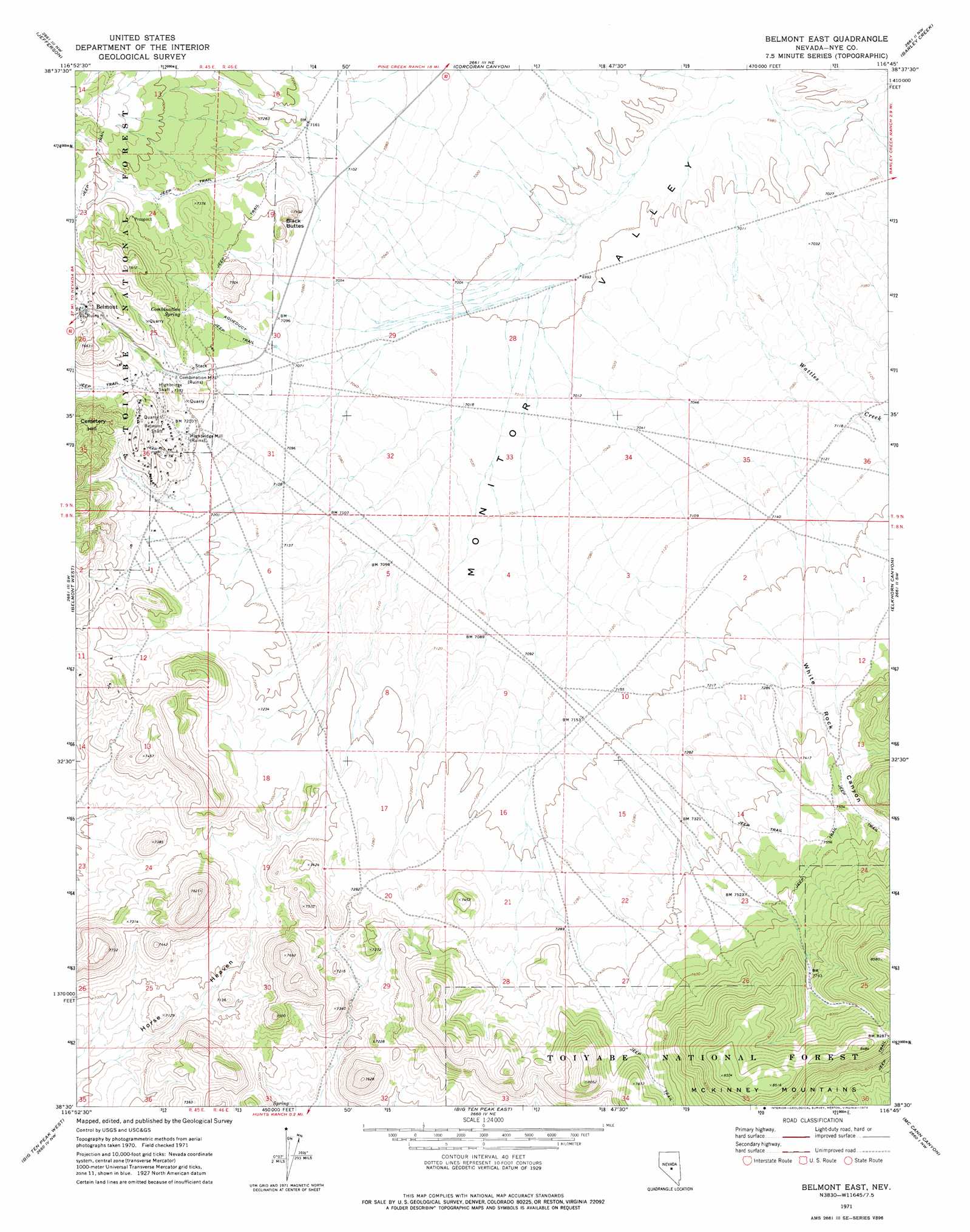
Belmont East Topo Map Nevada
To zoom in, hover over the map of Belmont East
USGS Topo Quad 38116e7 - 1:24,000 scale
| Topo Map Name: | Belmont East |
| USGS Topo Quad ID: | 38116e7 |
| Print Size: | ca. 21 1/4" wide x 27" high |
| Southeast Coordinates: | 38.5° N latitude / 116.75° W longitude |
| Map Center Coordinates: | 38.5625° N latitude / 116.8125° W longitude |
| U.S. State: | NV |
| Filename: | o38116e7.jpg |
| Download Map JPG Image: | Belmont East topo map 1:24,000 scale |
| Map Type: | Topographic |
| Topo Series: | 7.5´ |
| Map Scale: | 1:24,000 |
| Source of Map Images: | United States Geological Survey (USGS) |
| Alternate Map Versions: |
Belmont East NV 1971, updated 1974 Download PDF Buy paper map Belmont East NV 2012 Download PDF Buy paper map Belmont East NV 2014 Download PDF Buy paper map |
| FStopo: | US Forest Service topo Belmont East is available: Download FStopo PDF Download FStopo TIF |
1:24,000 Topo Quads surrounding Belmont East
Carvers Se |
Mount Jefferson |
Pine Creek Ranch |
Mosquito Creek |
Danville |
Round Mountain |
Jefferson |
Corcoran Canyon |
Barley Creek |
Green Monster Canyon |
Manhattan |
Belmont West |
Belmont East |
Elkhorn Canyon |
Eagle Pass |
Baxter Spring |
Big Ten Peak West |
Big Ten Peak East |
Mccann Canyon |
Mcintyre Summit |
Henrys Well |
Antelope Spring |
Saulsbury Basin |
Georges Canyon Rim |
Georges Canyon Rim Se |
> Back to 38116e1 at 1:100,000 scale
> Back to 38116a1 at 1:250,000 scale
> Back to U.S. Topo Maps home
Belmont East topo map: Gazetteer
Belmont East: Flats
Horse Heaven elevation 2084m 6837′Belmont East: Mines
Arizona Mine elevation 2274m 7460′Belmont Big Four Mine elevation 2342m 7683′
Belmont Shaft elevation 2231m 7319′
Canfield Mine elevation 2274m 7460′
El Dorado North Mine elevation 2274m 7460′
El Dorado South Mine elevation 2274m 7460′
Highbridge Shaft elevation 2231m 7319′
Monitor Belmont Mine elevation 2274m 7460′
Belmont East: Populated Places
Belmont elevation 2263m 7424′East Belmont (historical) elevation 2228m 7309′
Belmont East: Post Offices
Belmont Post Office (historical) elevation 2263m 7424′Belmont East: Springs
Combination Spring elevation 2230m 7316′Belmont East: Streams
Wattles Creek elevation 2131m 6991′Belmont East: Summits
Black Buttes elevation 2214m 7263′Belmont East: Valleys
Snowbird Canyon elevation 2295m 7529′White Rock Canyon elevation 2196m 7204′
Belmont East digital topo map on disk
Buy this Belmont East topo map showing relief, roads, GPS coordinates and other geographical features, as a high-resolution digital map file on DVD: