Morey Peak Topo Map Nevada
To zoom in, hover over the map of Morey Peak
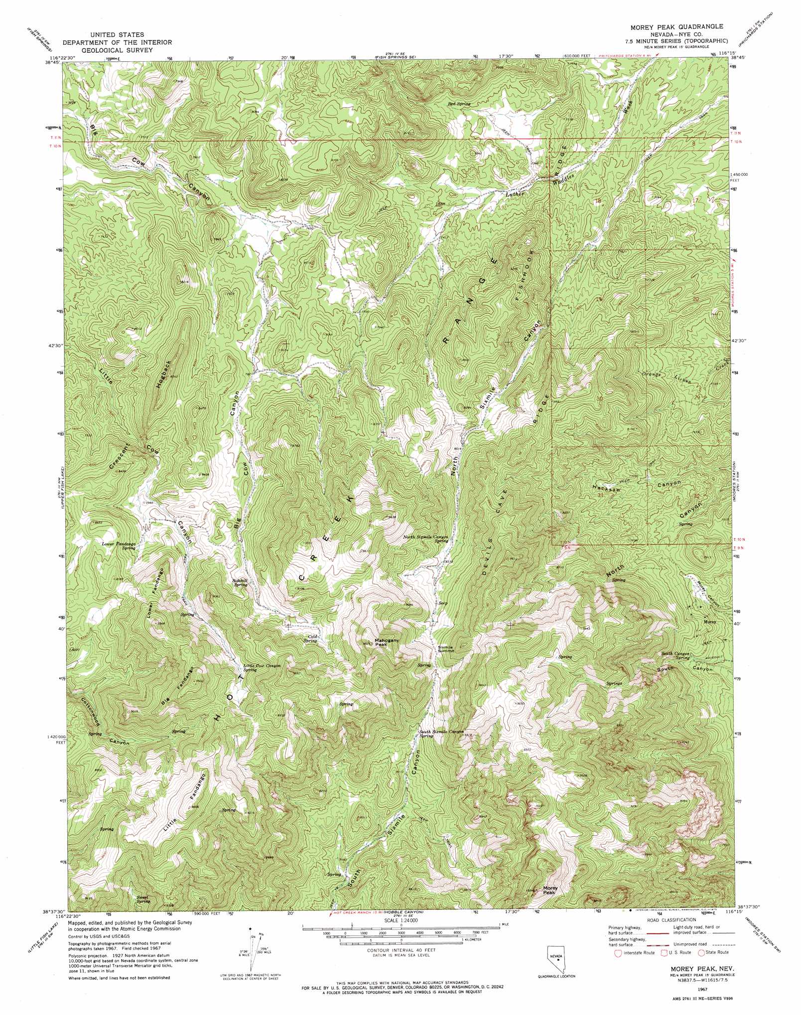
USGS Topo Quad 38116f3 - 1:24,000 scale
| Topo Map Name: | Morey Peak |
| USGS Topo Quad ID: | 38116f3 |
| Print Size: | ca. 21 1/4" wide x 27" high |
| Southeast Coordinates: | 38.625° N latitude / 116.25° W longitude |
| Map Center Coordinates: | 38.6875° N latitude / 116.3125° W longitude |
| U.S. State: | NV |
| Filename: | o38116f3.jpg |
| Download Map JPG Image: | Morey Peak topo map 1:24,000 scale |
| Map Type: | Topographic |
| Topo Series: | 7.5´ |
| Map Scale: | 1:24,000 |
| Source of Map Images: | United States Geological Survey (USGS) |
| Alternate Map Versions: |
Morey Peak NV 1967, updated 1973 Download PDF Buy paper map Morey Peak NV 2012 Download PDF Buy paper map Morey Peak NV 2014 Download PDF Buy paper map |
| FStopo: | US Forest Service topo Morey Peak is available: Download FStopo PDF Download FStopo TIF |
1:24,000 Topo Quads surrounding Morey Peak
Dobbin Summit |
Stargo Creek |
Fish Springs Ne |
Park Mountain |
Summit Station |
Danville |
Fish Springs |
Fish Springs Se |
Pritchards Station |
Red Ring Mountain |
Green Monster Canyon |
Upper Fish Lake |
Morey Peak |
Moores Station |
Chaos Creek |
Eagle Pass |
Little Fish Lake |
Hobble Canyon |
Moores Station Sw |
Moores Station Se |
Mcintyre Summit |
Flagstaff Mountain |
Blue Jay Spring |
Palisade Mesa |
Lunar Crater |
> Back to 38116e1 at 1:100,000 scale
> Back to 38116a1 at 1:250,000 scale
> Back to U.S. Topo Maps home
Morey Peak topo map: Gazetteer
Morey Peak: Cliffs
Six Mile Bluff elevation 2807m 9209′Morey Peak: Gaps
Sixmile Summit elevation 2675m 8776′Morey Peak: Mines
American Eagle Mine elevation 2299m 7542′Bay State Mine elevation 2299m 7542′
Black Hawk Mine elevation 2299m 7542′
Cedar Mine elevation 2299m 7542′
Kaiser Tunnel elevation 2198m 7211′
Magnolia Mine elevation 2299m 7542′
Morey Mine elevation 2260m 7414′
Mount Airy Mine elevation 2299m 7542′
Point of Rocks Mine elevation 2612m 8569′
Topside Mine elevation 2772m 9094′
Wist Mine elevation 2793m 9163′
Morey Peak: Populated Places
Morey elevation 2299m 7542′Morey Peak: Post Offices
Morey Post Office (historical) elevation 2198m 7211′Morey Peak: Ridges
Big Fandango elevation 2914m 9560′Crescent Hogback elevation 2511m 8238′
Devils Cave Ridge elevation 2926m 9599′
Fishhook Ridge elevation 2276m 7467′
Little Fandango elevation 2922m 9586′
Lower Fandango elevation 2665m 8743′
Morey Peak: Springs
Cold Spring elevation 2659m 8723′Little Cow Canyon Spring elevation 2640m 8661′
Lower Fandango Spring elevation 2476m 8123′
North Sixmile Canyon Spring elevation 2533m 8310′
Red Spring elevation 2279m 7477′
Sidehill Spring elevation 2557m 8389′
Six Mile Spring elevation 2702m 8864′
South Canyon Spring elevation 2245m 7365′
South Sixmile Canyon Spring elevation 2475m 8120′
Sweet Spring elevation 2448m 8031′
Morey Peak: Summits
Aspen Peak elevation 2933m 9622′Mahogany Peak elevation 2989m 9806′
Monitor Peak elevation 2833m 9294′
Morey Peak elevation 3105m 10187′
Tod Wattle Summit elevation 2461m 8074′
Morey Peak: Valleys
North Sixmile Canyon elevation 2157m 7076′Morey Peak digital topo map on disk
Buy this Morey Peak topo map showing relief, roads, GPS coordinates and other geographical features, as a high-resolution digital map file on DVD: