Mount Jefferson Topo Map Nevada
To zoom in, hover over the map of Mount Jefferson
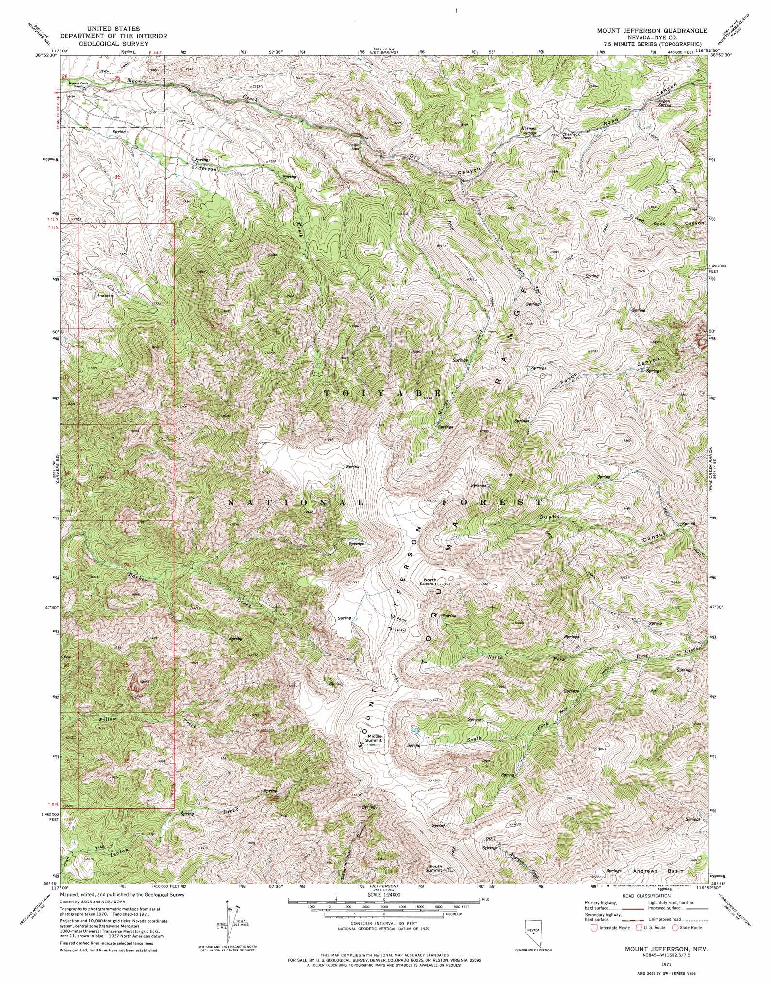
USGS Topo Quad 38116g8 - 1:24,000 scale
| Topo Map Name: | Mount Jefferson |
| USGS Topo Quad ID: | 38116g8 |
| Print Size: | ca. 21 1/4" wide x 27" high |
| Southeast Coordinates: | 38.75° N latitude / 116.875° W longitude |
| Map Center Coordinates: | 38.8125° N latitude / 116.9375° W longitude |
| U.S. State: | NV |
| Filename: | o38116g8.jpg |
| Download Map JPG Image: | Mount Jefferson topo map 1:24,000 scale |
| Map Type: | Topographic |
| Topo Series: | 7.5´ |
| Map Scale: | 1:24,000 |
| Source of Map Images: | United States Geological Survey (USGS) |
| Alternate Map Versions: |
Mount Jefferson NV 1971, updated 1975 Download PDF Buy paper map Mount Jefferson NV 1971, updated 1975 Download PDF Buy paper map Mount Jefferson NV 2012 Download PDF Buy paper map Mount Jefferson NV 2014 Download PDF Buy paper map |
| FStopo: | US Forest Service topo Mount Jefferson is available: Download FStopo PDF Download FStopo TIF |
1:24,000 Topo Quads surrounding Mount Jefferson
Millett Ranch |
East Of Millett Ranch |
Wildcat Canyon |
Wildcat Peak |
Dianas Punch Bowl |
Carvers Nw |
Carvers Ne |
Jet Spring |
Northumberland Pass |
Box Spring |
Carvers |
Carvers Se |
Mount Jefferson |
Pine Creek Ranch |
Mosquito Creek |
Pablo Canyon Ranch |
Round Mountain |
Jefferson |
Corcoran Canyon |
Barley Creek |
Seyler Peak |
Manhattan |
Belmont West |
Belmont East |
Elkhorn Canyon |
> Back to 38116e1 at 1:100,000 scale
> Back to 38116a1 at 1:250,000 scale
> Back to U.S. Topo Maps home
Mount Jefferson topo map: Gazetteer
Mount Jefferson: Gaps
Charnock Pass elevation 2543m 8343′Mount Jefferson: Mines
Jumping Jack Mine elevation 2206m 7237′Mount Jefferson: Ridges
Mount Jefferson elevation 3480m 11417′Mount Jefferson: Springs
Anderson Springs elevation 2110m 6922′Harmon Spring elevation 2510m 8234′
Logan Spring elevation 2429m 7969′
Mount Jefferson: Streams
North Fork Pine Creek elevation 2642m 8667′South Fork Pine Creek elevation 2642m 8667′
Mount Jefferson: Summits
Middle Summit Mount Jefferson elevation 3562m 11686′North Summit Mount Jefferson elevation 3601m 11814′
South Summit elevation 3637m 11932′
Mount Jefferson: Trails
Mount Jefferson Trail elevation 3512m 11522′Mount Jefferson: Valleys
Dry Canyon elevation 2282m 7486′Mount Jefferson digital topo map on disk
Buy this Mount Jefferson topo map showing relief, roads, GPS coordinates and other geographical features, as a high-resolution digital map file on DVD: