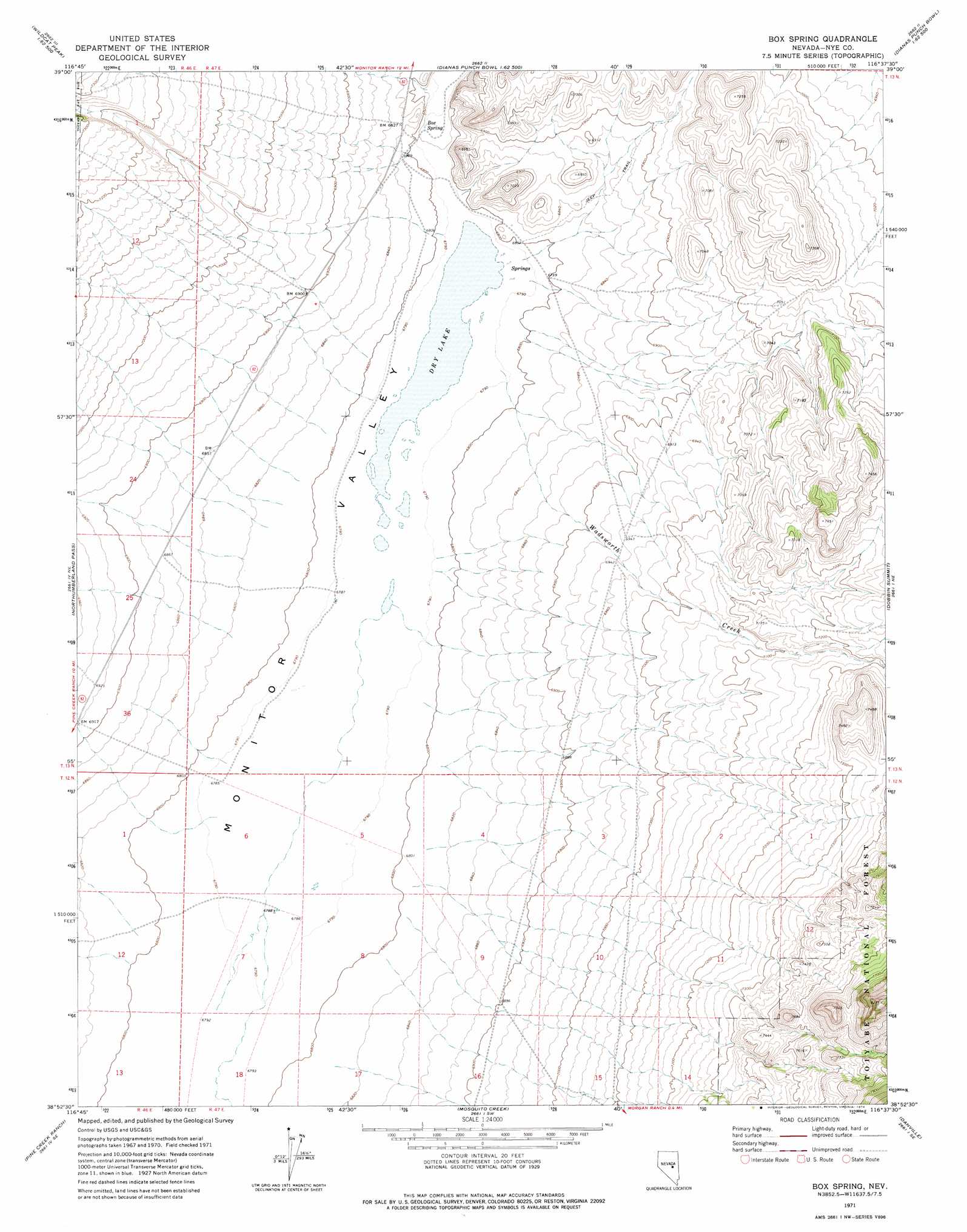
Box Spring Topo Map Nevada
To zoom in, hover over the map of Box Spring
USGS Topo Quad 38116h6 - 1:24,000 scale
| Topo Map Name: | Box Spring |
| USGS Topo Quad ID: | 38116h6 |
| Print Size: | ca. 21 1/4" wide x 27" high |
| Southeast Coordinates: | 38.875° N latitude / 116.625° W longitude |
| Map Center Coordinates: | 38.9375° N latitude / 116.6875° W longitude |
| U.S. State: | NV |
| Filename: | o38116h6.jpg |
| Download Map JPG Image: | Box Spring topo map 1:24,000 scale |
| Map Type: | Topographic |
| Topo Series: | 7.5´ |
| Map Scale: | 1:24,000 |
| Source of Map Images: | United States Geological Survey (USGS) |
| Alternate Map Versions: |
Box Spring NV 1971, updated 1974 Download PDF Buy paper map Box Spring NV 2012 Download PDF Buy paper map Box Spring NV 2014 Download PDF Buy paper map |
| FStopo: | US Forest Service topo Box Spring is available: Download FStopo PDF Download FStopo TIF |
1:24,000 Topo Quads surrounding Box Spring
Wildcat Peak Nw |
Petes Summit |
The Monitor |
White Sage Canyon |
Horse Heaven Mountain |
Wildcat Canyon |
Wildcat Peak |
Dianas Punch Bowl |
Butler Ranch |
Savory Mountain |
Jet Spring |
Northumberland Pass |
Box Spring |
Dobbin Summit |
Stargo Creek |
Mount Jefferson |
Pine Creek Ranch |
Mosquito Creek |
Danville |
Fish Springs |
Jefferson |
Corcoran Canyon |
Barley Creek |
Green Monster Canyon |
Upper Fish Lake |
> Back to 38116e1 at 1:100,000 scale
> Back to 38116a1 at 1:250,000 scale
> Back to U.S. Topo Maps home
Box Spring topo map: Gazetteer
Box Spring: Lakes
Dry Lake elevation 2071m 6794′Box Spring: Springs
Box Spring elevation 2084m 6837′Box Spring: Streams
Wadsworth Creek elevation 2071m 6794′Box Spring: Trails
Austin Belmont Stage Route elevation 2112m 6929′Box Spring: Valleys
Mill Canyon elevation 2106m 6909′Willow Canyon elevation 2080m 6824′
Box Spring digital topo map on disk
Buy this Box Spring topo map showing relief, roads, GPS coordinates and other geographical features, as a high-resolution digital map file on DVD: