Northumberland Pass Topo Map Nevada
To zoom in, hover over the map of Northumberland Pass
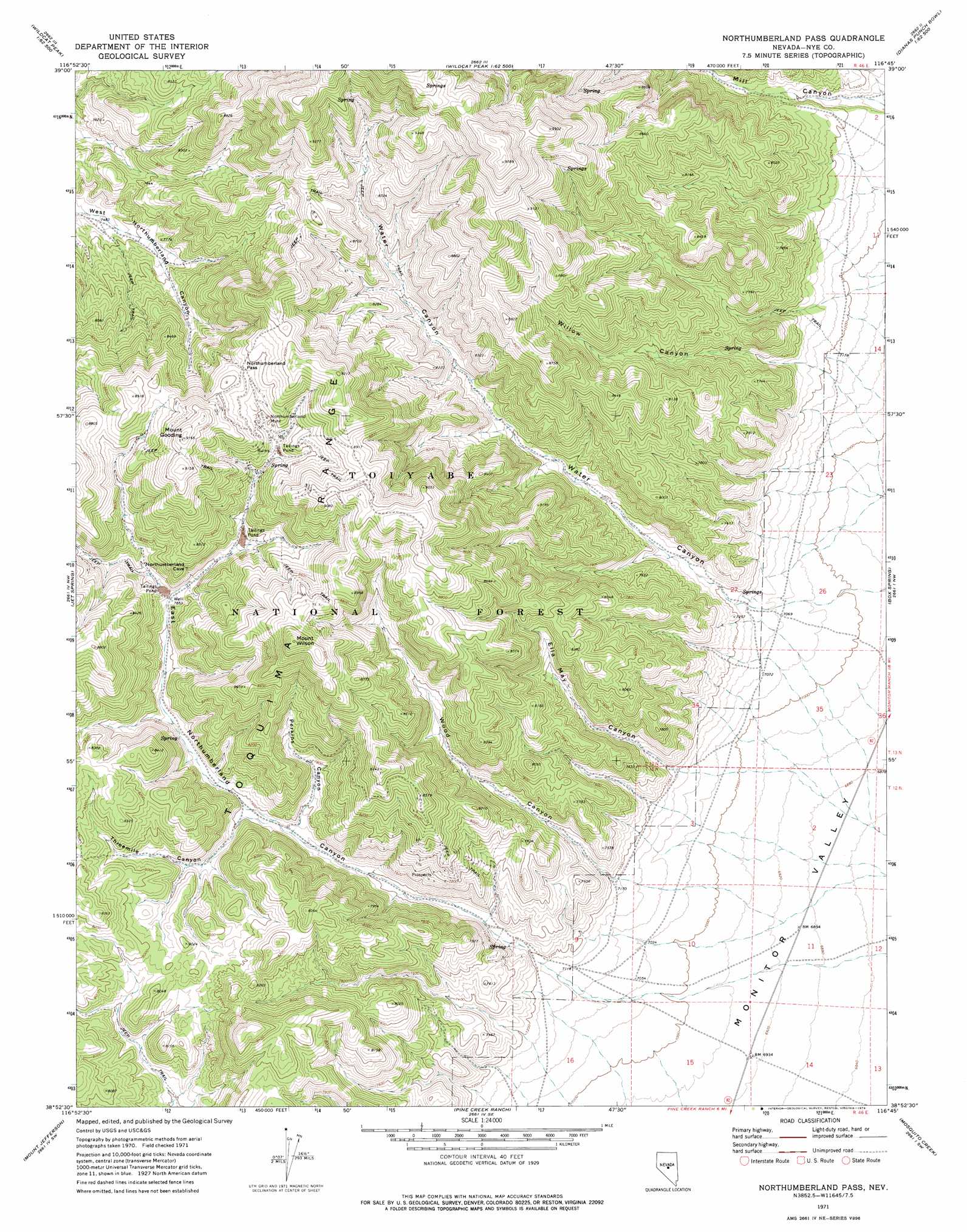
USGS Topo Quad 38116h7 - 1:24,000 scale
| Topo Map Name: | Northumberland Pass |
| USGS Topo Quad ID: | 38116h7 |
| Print Size: | ca. 21 1/4" wide x 27" high |
| Southeast Coordinates: | 38.875° N latitude / 116.75° W longitude |
| Map Center Coordinates: | 38.9375° N latitude / 116.8125° W longitude |
| U.S. State: | NV |
| Filename: | o38116h7.jpg |
| Download Map JPG Image: | Northumberland Pass topo map 1:24,000 scale |
| Map Type: | Topographic |
| Topo Series: | 7.5´ |
| Map Scale: | 1:24,000 |
| Source of Map Images: | United States Geological Survey (USGS) |
| Alternate Map Versions: |
Northumberland Pass NV 1971, updated 1974 Download PDF Buy paper map Northumberland Pass NV 2012 Download PDF Buy paper map Northumberland Pass NV 2014 Download PDF Buy paper map |
| FStopo: | US Forest Service topo Northumberland Pass is available: Download FStopo PDF Download FStopo TIF |
1:24,000 Topo Quads surrounding Northumberland Pass
Kingston |
Wildcat Peak Nw |
Petes Summit |
The Monitor |
White Sage Canyon |
East Of Millett Ranch |
Wildcat Canyon |
Wildcat Peak |
Dianas Punch Bowl |
Butler Ranch |
Carvers Ne |
Jet Spring |
Northumberland Pass |
Box Spring |
Dobbin Summit |
Carvers Se |
Mount Jefferson |
Pine Creek Ranch |
Mosquito Creek |
Danville |
Round Mountain |
Jefferson |
Corcoran Canyon |
Barley Creek |
Green Monster Canyon |
> Back to 38116e1 at 1:100,000 scale
> Back to 38116a1 at 1:250,000 scale
> Back to U.S. Topo Maps home
Northumberland Pass topo map: Gazetteer
Northumberland Pass: Gaps
Northumberland Pass elevation 2657m 8717′Northumberland Pass: Mines
Blue Bell Mine elevation 2689m 8822′Blue Point Mine elevation 2418m 7933′
Last Chance Mine elevation 2699m 8854′
Monitor Mine elevation 2692m 8832′
Mormon Mine elevation 2657m 8717′
Mount Ruby Mine elevation 2418m 7933′
Mountain Chief Mine elevation 2418m 7933′
Northumberland Mine elevation 2609m 8559′
Northumberland Pass: Populated Places
Learville (historical) elevation 2486m 8156′Northumberland (historical) elevation 2547m 8356′
Northumberland Pass: Post Offices
Learville Post Office elevation 2486m 8156′Northumberland Post Office (historical) elevation 2547m 8356′
Northumberland Pass: Ranges
Toquima Range elevation 2723m 8933′Northumberland Pass: Springs
Northumberland Spring elevation 2214m 7263′Side Hill Spring elevation 2398m 7867′
Water Canyon Springs elevation 2173m 7129′
Northumberland Pass: Summits
Mount Gooding elevation 2789m 9150′Mount Wilson elevation 2794m 9166′
Northumberland Pass: Trails
Ox Freight Route elevation 2220m 7283′Northumberland Pass: Valleys
August Canyon elevation 2211m 7253′East Northumberland Canyon elevation 2178m 7145′
Ella May Canyon elevation 2181m 7155′
Perkins Canyon elevation 2295m 7529′
Threemile Canyon elevation 2316m 7598′
Water Canyon elevation 2175m 7135′
Wood Canyon elevation 2185m 7168′
Northumberland Pass digital topo map on disk
Buy this Northumberland Pass topo map showing relief, roads, GPS coordinates and other geographical features, as a high-resolution digital map file on DVD: