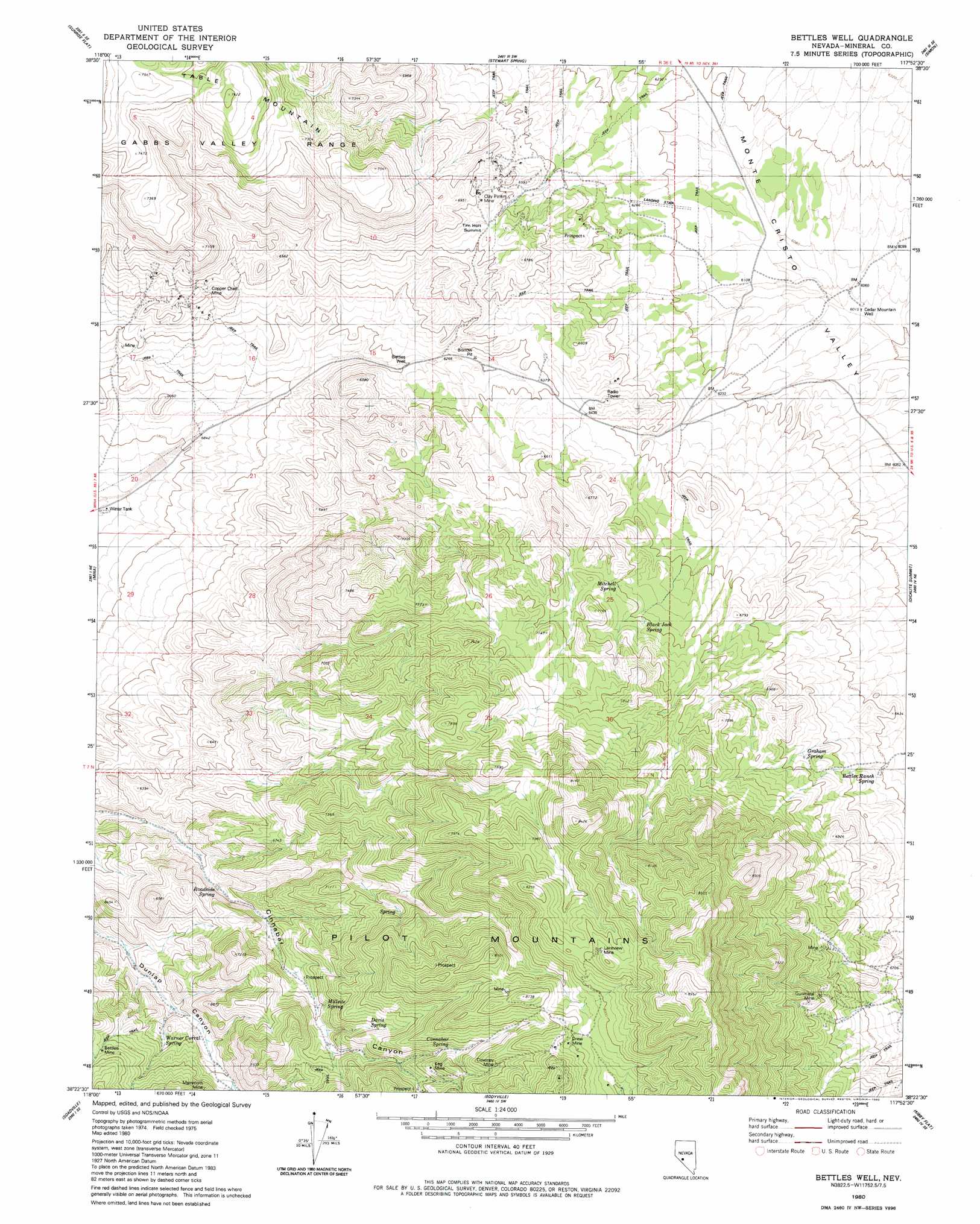
Bettles Well Topo Map Nevada
To zoom in, hover over the map of Bettles Well
USGS Topo Quad 38117d8 - 1:24,000 scale
| Topo Map Name: | Bettles Well |
| USGS Topo Quad ID: | 38117d8 |
| Print Size: | ca. 21 1/4" wide x 27" high |
| Southeast Coordinates: | 38.375° N latitude / 117.875° W longitude |
| Map Center Coordinates: | 38.4375° N latitude / 117.9375° W longitude |
| U.S. State: | NV |
| Filename: | o38117d8.jpg |
| Download Map JPG Image: | Bettles Well topo map 1:24,000 scale |
| Map Type: | Topographic |
| Topo Series: | 7.5´ |
| Map Scale: | 1:24,000 |
| Source of Map Images: | United States Geological Survey (USGS) |
| Alternate Map Versions: |
Bettles Well NV 1980, updated 1980 Download PDF Buy paper map Bettles Well NV 2012 Download PDF Buy paper map Bettles Well NV 2014 Download PDF Buy paper map |
1:24,000 Topo Quads surrounding Bettles Well
Mount Ferguson |
Gabbs Mountain |
Granny Goose Well |
Goldyke |
Black Spring Nw |
Luning |
Sunrise Flat |
Stewart Spring |
Simon |
Black Spring |
Black Dyke Mountain |
Mina |
Bettles Well |
Dicalite Summit |
Cole Spring |
Camp Douglas |
Sodaville |
Eddyville |
Kirby Flat |
Outlaw Springs |
Belleville |
Candelaria |
Rock Hill |
Coaldale Ne |
Gilbert |
> Back to 38117a1 at 1:100,000 scale
> Back to 38116a1 at 1:250,000 scale
> Back to U.S. Topo Maps home
Bettles Well topo map: Gazetteer
Bettles Well: Gaps
Tim Holt Summit elevation 2032m 6666′Bettles Well: Mines
Bettles Mine elevation 2104m 6902′Clay Peters Mine elevation 2063m 6768′
Copper Chief Mine elevation 1977m 6486′
Coveney Mine elevation 2385m 7824′
Drew Mine elevation 2443m 8015′
Garnet Mine elevation 2156m 7073′
Gunmetal Mine elevation 2219m 7280′
Keg Mine elevation 2291m 7516′
Kope Scheelite Mine elevation 2061m 6761′
Lakeview Mine elevation 2532m 8307′
Lindsey Mine elevation 2315m 7595′
Mammoth Mine elevation 2113m 6932′
Redwing Mine elevation 1870m 6135′
Bettles Well: Springs
Bettles Ranch Spring elevation 1964m 6443′Black Jack Spring elevation 2079m 6820′
Cinnabar Spring elevation 2273m 7457′
Corner Spring elevation 2044m 6706′
Davis Spring elevation 2182m 7158′
Graham Spring elevation 2049m 6722′
Millsite Spring elevation 2083m 6833′
Mitchell Spring elevation 2078m 6817′
Mitchell Spring elevation 2171m 7122′
Point of Hill Spring elevation 2009m 6591′
Roadside Spring elevation 1915m 6282′
South Mitchell Spring elevation 2013m 6604′
Taylor Spring elevation 2075m 6807′
Warner Corral Spring elevation 1989m 6525′
Wild Cat Spring elevation 1866m 6122′
Yellow Spring elevation 2194m 7198′
Bettles Well: Summits
Table Mountain elevation 2310m 7578′Bettles Well: Wells
Bettles Well elevation 1891m 6204′Cedar Mountain Well elevation 1838m 6030′
Bettles Well digital topo map on disk
Buy this Bettles Well topo map showing relief, roads, GPS coordinates and other geographical features, as a high-resolution digital map file on DVD: