Powell Mountain Topo Map Nevada
To zoom in, hover over the map of Powell Mountain
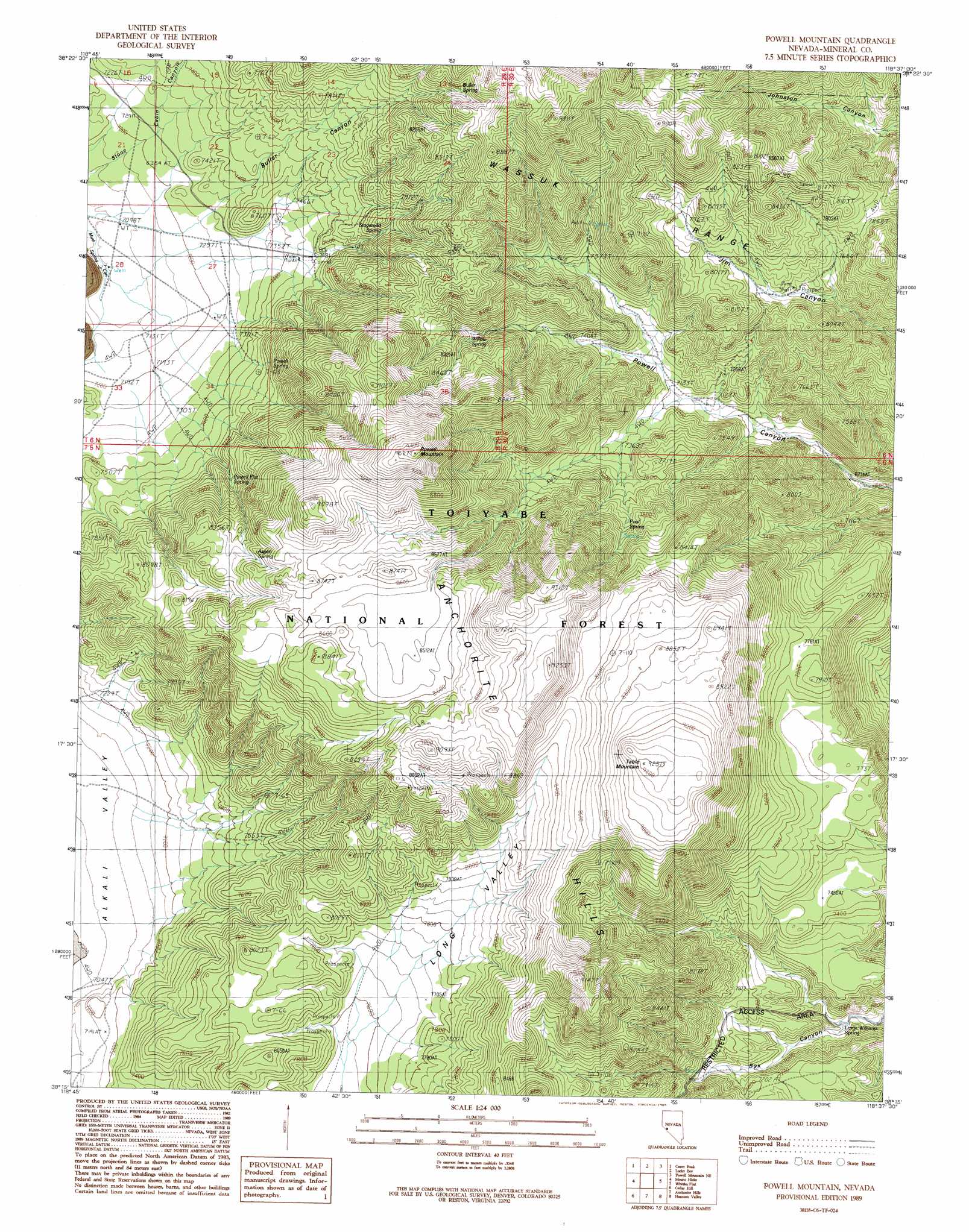
USGS Topo Quad 38118c6 - 1:24,000 scale
| Topo Map Name: | Powell Mountain |
| USGS Topo Quad ID: | 38118c6 |
| Print Size: | ca. 21 1/4" wide x 27" high |
| Southeast Coordinates: | 38.25° N latitude / 118.625° W longitude |
| Map Center Coordinates: | 38.3125° N latitude / 118.6875° W longitude |
| U.S. State: | NV |
| Filename: | o38118c6.jpg |
| Download Map JPG Image: | Powell Mountain topo map 1:24,000 scale |
| Map Type: | Topographic |
| Topo Series: | 7.5´ |
| Map Scale: | 1:24,000 |
| Source of Map Images: | United States Geological Survey (USGS) |
| Alternate Map Versions: |
Powell Mountain NV 1989, updated 1989 Download PDF Buy paper map Powell Mountain NV 2011 Download PDF Buy paper map Powell Mountain NV 2014 Download PDF Buy paper map |
| FStopo: | US Forest Service topo Powell Mountain is available: Download FStopo PDF Download FStopo TIF |
1:24,000 Topo Quads surrounding Powell Mountain
Mitchell Spring |
Mount Grant |
Hawthorne West |
Hawthorne East |
Kinkaid |
Ninemile Ranch |
Corey Peak |
Lucky Boy |
Powell Mountain Ne |
Pamlico |
Aurora |
Mount Hicks |
Powell Mountain |
Whisky Flat |
Rattlesnake Flat |
Kirkwood Spring |
Cedar Hill |
Anchorite Hills |
Huntoon Valley |
Little Huntoon Valley |
Sulphur Pond |
Alameda Well |
West Of Huntoon Spring |
Huntoon Spring |
Jacks Spring |
> Back to 38118a1 at 1:100,000 scale
> Back to 38118a1 at 1:250,000 scale
> Back to U.S. Topo Maps home
Powell Mountain topo map: Gazetteer
Powell Mountain: Mines
Rising Sun Mine elevation 2355m 7726′Powell Mountain: Springs
Alder Spring elevation 2333m 7654′Aspen Spring elevation 2559m 8395′
Hay Spring elevation 2220m 7283′
Log Cabin Spring elevation 2333m 7654′
Lost Spring elevation 2497m 8192′
Pool Spring elevation 2386m 7828′
Powell Flat Spring elevation 2374m 7788′
Powell Spring elevation 2300m 7545′
Stageroad Spring elevation 2361m 7746′
Upper Powell Canyon Spring elevation 2224m 7296′
Willow Spring elevation 2439m 8001′
Powell Mountain: Summits
Powell Mountain elevation 2903m 9524′Table Mountain elevation 2752m 9028′
Powell Mountain: Valleys
Buller Canyon elevation 2220m 7283′Powell Mountain digital topo map on disk
Buy this Powell Mountain topo map showing relief, roads, GPS coordinates and other geographical features, as a high-resolution digital map file on DVD: