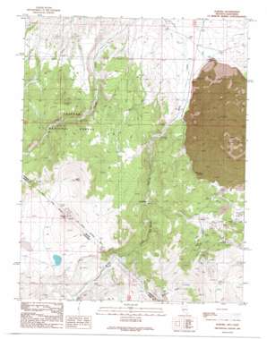
Aurora Topo Map Nevada
To zoom in, hover over the map of Aurora
USGS Topo Quad 38118c8 - 1:24,000 scale
| Topo Map Name: | Aurora |
| USGS Topo Quad ID: | 38118c8 |
| Print Size: | ca. 21 1/4" wide x 27" high |
| Southeast Coordinates: | 38.25° N latitude / 118.875° W longitude |
| Map Center Coordinates: | 38.3125° N latitude / 118.9375° W longitude |
| U.S. States: | NV, CA |
| Filename: | o38118c8.jpg |
| Download Map JPG Image: | Aurora topo map 1:24,000 scale |
| Map Type: | Topographic |
| Topo Series: | 7.5´ |
| Map Scale: | 1:24,000 |
| Source of Map Images: | United States Geological Survey (USGS) |
| Alternate Map Versions: |
Aurora NV 1989, updated 1989 Download PDF Buy paper map Aurora NV 2012 Download PDF Buy paper map Aurora NV 2014 Download PDF Buy paper map |
| FStopo: | US Forest Service topo Aurora is available: Download FStopo PDF Download FStopo TIF |
1:24,000 Topo Quads surrounding Aurora
> Back to 38118a1 at 1:100,000 scale
> Back to 38118a1 at 1:250,000 scale
> Back to U.S. Topo Maps home
Aurora topo map: Gazetteer
Aurora: Craters
Aurora Crater elevation 2284m 7493′Aurora: Lakes
Dry Lake elevation 2523m 8277′Aurora: Mines
Aurora Tunnel elevation 2268m 7440′Chesco Mine elevation 2246m 7368′
Esmeralda Tunnel elevation 2268m 7440′
Horatio Tunnel elevation 2268m 7440′
Illinois Tunnel elevation 2268m 7440′
Juanita Tunnel elevation 2268m 7440′
Martinez Tunnel elevation 2268m 7440′
Montezuma Tunnel elevation 2268m 7440′
Montreal Tunnel elevation 2268m 7440′
National Tunnel elevation 2268m 7440′
Popper Mine elevation 2018m 6620′
Union Tunnel elevation 2268m 7440′
Aurora: Populated Places
Aurora (historical) elevation 2268m 7440′Del Monte elevation 2110m 6922′
Esmeralda (historical) elevation 2244m 7362′
Fletcher elevation 1865m 6118′
Aurora: Post Offices
Aurora Post Office (historical) elevation 2268m 7440′Esmeralda Post Office (historical) elevation 2244m 7362′
Fletcher Post Office (historical) elevation 1865m 6118′
Aurora: Springs
Barrel Spring elevation 2235m 7332′Fletcher Spring elevation 1866m 6122′
Tamarack Spring elevation 2462m 8077′
Aurora: Streams
Aurora Creek elevation 2138m 7014′Aurora: Summits
Aurora Hill elevation 2305m 7562′Bald Peak elevation 2685m 8809′
Beauty Peak elevation 2743m 8999′
Beauty Peak elevation 2740m 8989′
Humboldt Hill elevation 2266m 7434′
Last Chance Hill elevation 2308m 7572′
Martinez Hill elevation 2467m 8093′
Middle Hill elevation 2486m 8156′
Saint Marys Hill elevation 2485m 8152′
Silver Hill elevation 2540m 8333′
Sugarloaf Mountain elevation 2333m 7654′
Aurora: Valleys
Del Monte Canyon elevation 1915m 6282′Esmeralda Ravine elevation 2256m 7401′
Mud Spring Canyon elevation 1889m 6197′
Willow Ravine elevation 2268m 7440′
Aurora digital topo map on disk
Buy this Aurora topo map showing relief, roads, GPS coordinates and other geographical features, as a high-resolution digital map file on DVD:


