Big Alkali Topo Map California
To zoom in, hover over the map of Big Alkali
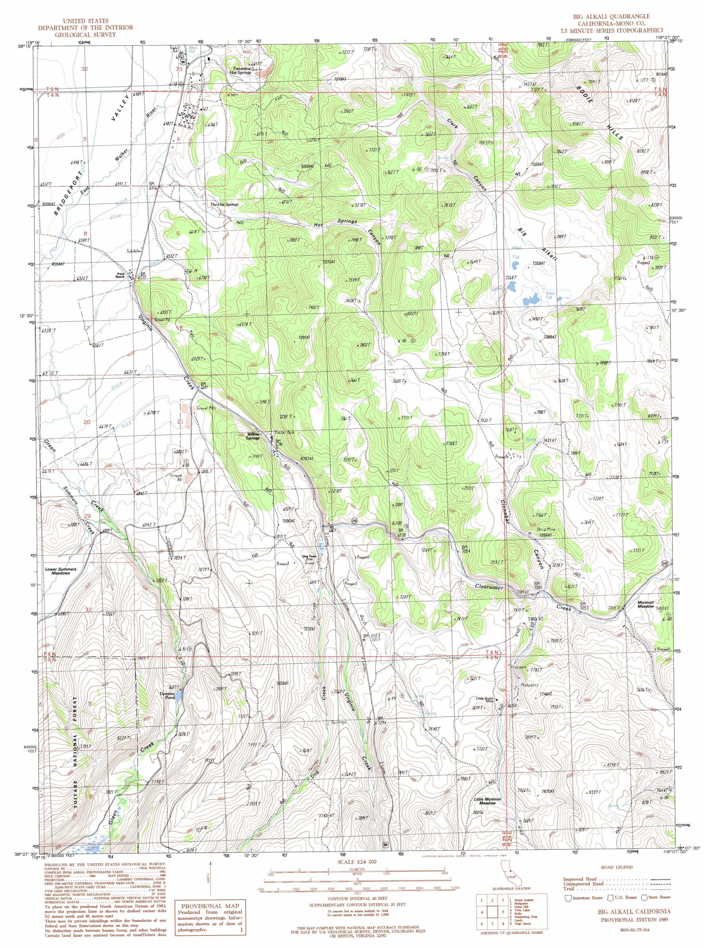
USGS Topo Quad 38119b2 - 1:24,000 scale
| Topo Map Name: | Big Alkali |
| USGS Topo Quad ID: | 38119b2 |
| Print Size: | ca. 21 1/4" wide x 27" high |
| Southeast Coordinates: | 38.125° N latitude / 119.125° W longitude |
| Map Center Coordinates: | 38.1875° N latitude / 119.1875° W longitude |
| U.S. State: | CA |
| Filename: | o38119b2.jpg |
| Download Map JPG Image: | Big Alkali topo map 1:24,000 scale |
| Map Type: | Topographic |
| Topo Series: | 7.5´ |
| Map Scale: | 1:24,000 |
| Source of Map Images: | United States Geological Survey (USGS) |
| Alternate Map Versions: |
Big Alkali CA 1989, updated 1989 Download PDF Buy paper map Big Alkali CA 1989, updated 1989 Download PDF Buy paper map Big Alkali CA 2012 Download PDF Buy paper map Big Alkali CA 2015 Download PDF Buy paper map |
| FStopo: | US Forest Service topo Big Alkali is available: Download FStopo PDF Download FStopo TIF |
1:24,000 Topo Quads surrounding Big Alkali
Chris Flat |
Mount Patterson |
Sweetwater Creek |
The Elbow |
Ninemile Ranch |
Fales Hot Springs |
Mount Jackson |
Bridgeport |
Dome Hill |
Aurora |
Buckeye Ridge |
Twin Lakes |
Big Alkali |
Bodie |
Kirkwood Spring |
Matterhorn Peak |
Dunderberg Peak |
Lundy |
Negit Island |
Sulphur Pond |
Falls Ridge |
Tioga Pass |
Mount Dana |
Lee Vining |
Mono Mills |
> Back to 38119a1 at 1:100,000 scale
> Back to 38118a1 at 1:250,000 scale
> Back to U.S. Topo Maps home
Big Alkali topo map: Gazetteer
Big Alkali: Flats
Big Alkali elevation 2243m 7358′Little Mormon Meadow elevation 2347m 7700′
Lower Summers Meadows elevation 2085m 6840′
Mormon Meadow elevation 2232m 7322′
Big Alkali: Lakes
Dynamo Pond elevation 2318m 7604′Big Alkali: Mines
Little Bodie Mine elevation 2309m 7575′Big Alkali: Populated Places
Dog Town elevation 2151m 7057′Willow Springs elevation 2056m 6745′
Big Alkali: Springs
The Hot Spring elevation 2013m 6604′Travertine Hot Spring elevation 2060m 6758′
Big Alkali: Streams
Clearwater Creek elevation 2084m 6837′Dog Creek elevation 2111m 6925′
Green Creek elevation 1983m 6505′
Virginia Creek elevation 1983m 6505′
Big Alkali: Valleys
Chinnabar Canyon elevation 2207m 7240′Cinnabar Canyon elevation 2202m 7224′
Hot Springs Canyon elevation 2030m 6660′
Big Alkali digital topo map on disk
Buy this Big Alkali topo map showing relief, roads, GPS coordinates and other geographical features, as a high-resolution digital map file on DVD: