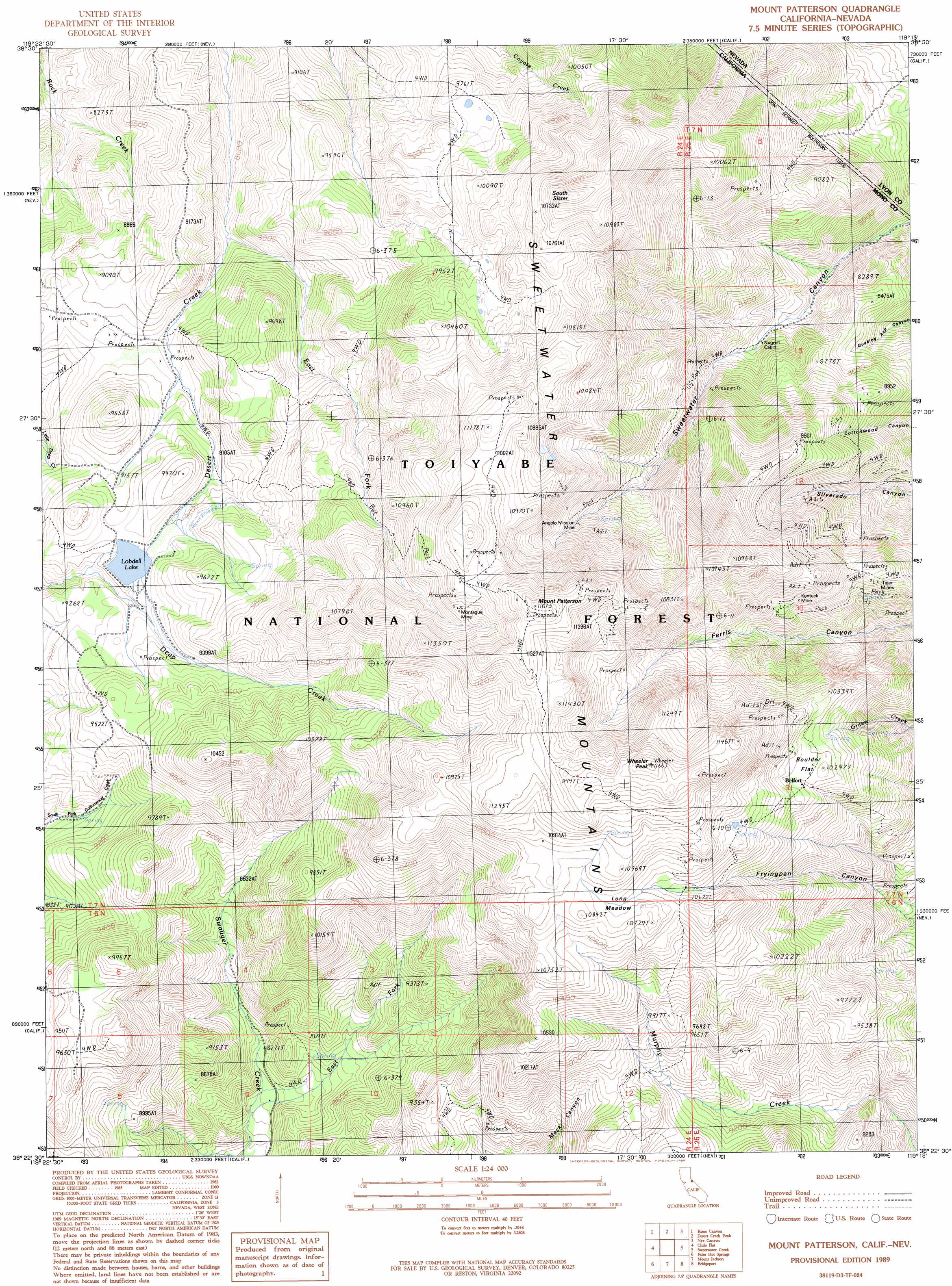
Mount Patterson Topo Map California
To zoom in, hover over the map of Mount Patterson
USGS Topo Quad 38119d3 - 1:24,000 scale
| Topo Map Name: | Mount Patterson |
| USGS Topo Quad ID: | 38119d3 |
| Print Size: | ca. 21 1/4" wide x 27" high |
| Southeast Coordinates: | 38.375° N latitude / 119.25° W longitude |
| Map Center Coordinates: | 38.4375° N latitude / 119.3125° W longitude |
| U.S. States: | CA, NV |
| Filename: | o38119d3.jpg |
| Download Map JPG Image: | Mount Patterson topo map 1:24,000 scale |
| Map Type: | Topographic |
| Topo Series: | 7.5´ |
| Map Scale: | 1:24,000 |
| Source of Map Images: | United States Geological Survey (USGS) |
| Alternate Map Versions: |
Mount Patterson CA 1989, updated 1989 Download PDF Buy paper map Mount Patterson CA 1989, updated 1989 Download PDF Buy paper map Mount Patterson CA 2012 Download PDF Buy paper map Mount Patterson CA 2015 Download PDF Buy paper map |
| FStopo: | US Forest Service topo Mount Patterson is available: Download FStopo PDF Download FStopo TIF |
1:24,000 Topo Quads surrounding Mount Patterson
Topaz Lake |
Long Dry Canyon |
Desert Creek Ranch |
Mount Etna |
Pine Grove Spring |
Coleville |
Risue Canyon |
Desert Creek Peak |
Nye Canyon |
Wichman Canyon |
Lost Cannon Peak |
Chris Flat |
Mount Patterson |
Sweetwater Creek |
The Elbow |
Pickel Meadow |
Fales Hot Springs |
Mount Jackson |
Bridgeport |
Dome Hill |
Tower Peak |
Buckeye Ridge |
Twin Lakes |
Big Alkali |
Bodie |
> Back to 38119a1 at 1:100,000 scale
> Back to 38118a1 at 1:250,000 scale
> Back to U.S. Topo Maps home
Mount Patterson topo map: Gazetteer
Mount Patterson: Dams
Lobdell Lake Dam elevation 2816m 9238′Mount Patterson: Flats
Boulder Flat elevation 3124m 10249′Long Meadow elevation 3245m 10646′
Mount Patterson: Mines
Angelo Mission Mine elevation 3003m 9852′Frederick Mine elevation 3119m 10232′
Kentuck Mine elevation 3025m 9924′
Longstreet Mine (historical) elevation 2691m 8828′
Montague Mine elevation 3350m 10990′
Tiger Mines elevation 2962m 9717′
Mount Patterson: Populated Places
Belfort elevation 3112m 10209′Mount Patterson: Ranges
Sweetwater Mountains elevation 3551m 11650′Mount Patterson: Reservoirs
Lobdell Lake elevation 2816m 9238′Mount Patterson: Streams
East Fork Desert Creek elevation 2653m 8704′East Fork Swauger Creek elevation 2477m 8126′
Mount Patterson: Summits
Mount Patterson elevation 3552m 11653′South Sister elevation 3442m 11292′
Wheeler Peak elevation 3545m 11630′
Mount Patterson digital topo map on disk
Buy this Mount Patterson topo map showing relief, roads, GPS coordinates and other geographical features, as a high-resolution digital map file on DVD: