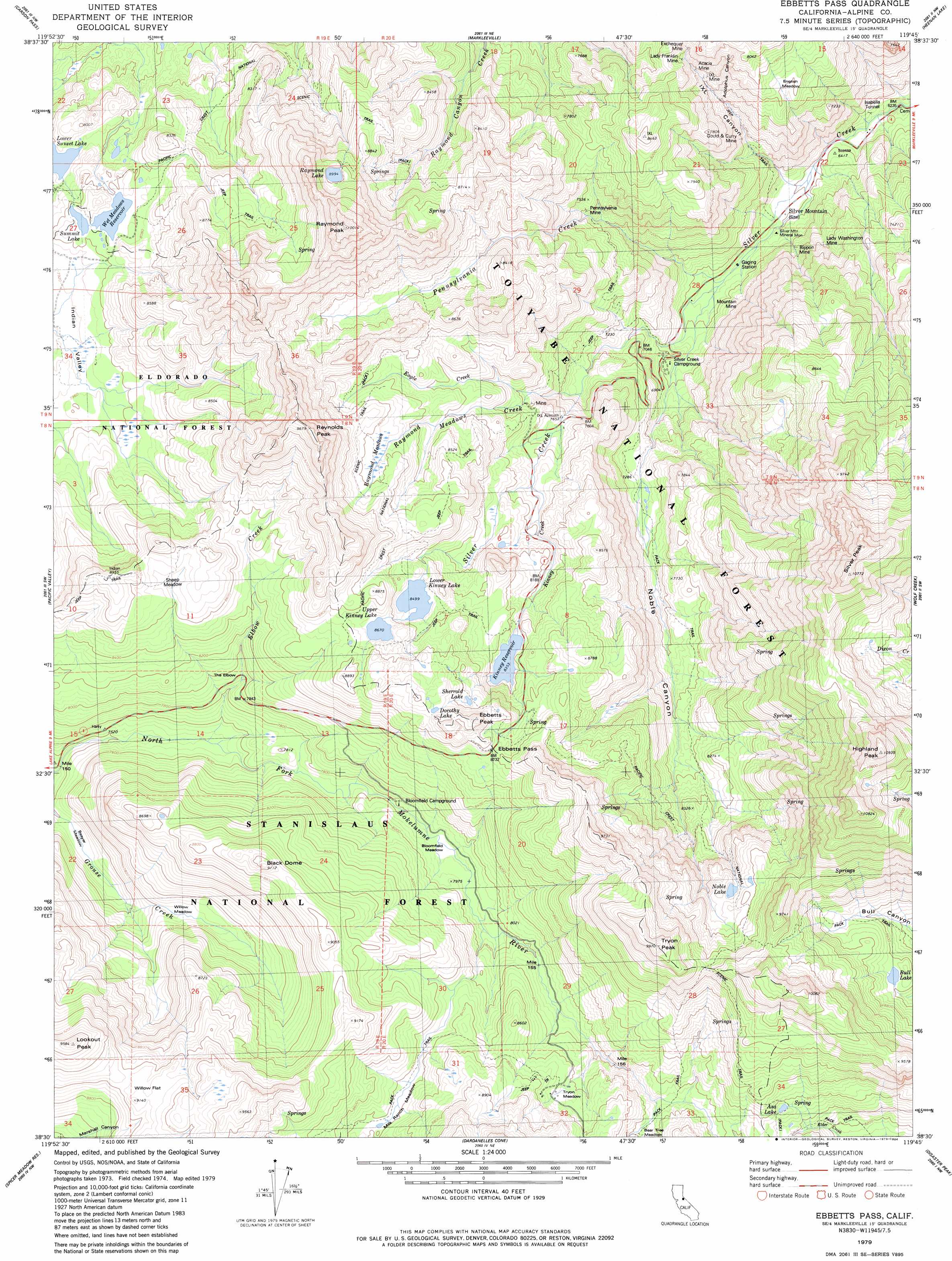
Ebbetts Pass Topo Map California
To zoom in, hover over the map of Ebbetts Pass
USGS Topo Quad 38119e7 - 1:24,000 scale
| Topo Map Name: | Ebbetts Pass |
| USGS Topo Quad ID: | 38119e7 |
| Print Size: | ca. 21 1/4" wide x 27" high |
| Southeast Coordinates: | 38.5° N latitude / 119.75° W longitude |
| Map Center Coordinates: | 38.5625° N latitude / 119.8125° W longitude |
| U.S. State: | CA |
| Filename: | o38119e7.jpg |
| Download Map JPG Image: | Ebbetts Pass topo map 1:24,000 scale |
| Map Type: | Topographic |
| Topo Series: | 7.5´ |
| Map Scale: | 1:24,000 |
| Source of Map Images: | United States Geological Survey (USGS) |
| Alternate Map Versions: |
Ebbetts Pass CA 1979, updated 1979 Download PDF Buy paper map Ebbetts Pass CA 1979, updated 1979 Download PDF Buy paper map Ebbetts Pass CA 1979, updated 1979 Download PDF Buy paper map Ebbetts Pass CA 1979, updated 1984 Download PDF Buy paper map Ebbetts Pass CA 2001, updated 2004 Download PDF Buy paper map Ebbetts Pass CA 2001, updated 2004 Download PDF Buy paper map Ebbetts Pass CA 2012 Download PDF Buy paper map Ebbetts Pass CA 2015 Download PDF Buy paper map |
| FStopo: | US Forest Service topo Ebbetts Pass is available: Download FStopo PDF Download FStopo TIF |
1:24,000 Topo Quads surrounding Ebbetts Pass
Echo Lake |
Freel Peak |
Woodfords |
Carters Station |
Double Spring |
Caples Lake |
Carson Pass |
Markleeville |
Heenan Lake |
Topaz Lake |
Mokelumne Peak |
Pacific Valley |
Ebbetts Pass |
Wolf Creek |
Coleville |
Tamarack |
Spicer Meadow Res |
Dardanelles Cone |
Disaster Peak |
Lost Cannon Peak |
Liberty Hill |
Donnell Lake |
Dardanelle |
Sonora Pass |
Pickel Meadow |
> Back to 38119e1 at 1:100,000 scale
> Back to 38118a1 at 1:250,000 scale
> Back to U.S. Topo Maps home
Ebbetts Pass topo map: Gazetteer
Ebbetts Pass: Basins
Indian Valley elevation 2412m 7913′Ebbetts Pass: Dams
Kinney Meadows 513 Dam elevation 2549m 8362′Lower Kinney Lake 513-002 Dam elevation 2592m 8503′
Upper Kinney Lake 513-006 Dam elevation 2644m 8674′
Wet Meadows 513-008 Dam elevation 2450m 8038′
Ebbetts Pass: Flats
Beaver Meadow elevation 2262m 7421′Bloomfield Meadow elevation 2398m 7867′
English Meadow elevation 2315m 7595′
Milk Ranch Meadow elevation 2561m 8402′
Raymond Meadows elevation 2609m 8559′
Sheep Meadow elevation 2636m 8648′
Tryon Meadow elevation 2571m 8435′
Wet Meadows elevation 2450m 8038′
Willow Flat elevation 2769m 9084′
Willow Meadow elevation 2396m 7860′
Ebbetts Pass: Gaps
Ebbetts Pass elevation 2669m 8756′Ebbetts Pass: Lakes
Asa Lake elevation 2609m 8559′Bull Lake elevation 2629m 8625′
Dorothy Lake elevation 2716m 8910′
Lower Kinney Lake elevation 2644m 8674′
Noble Lake elevation 2703m 8868′
Raymond Lake elevation 2743m 8999′
Sherrold Lake elevation 2670m 8759′
Summit Lake elevation 2445m 8021′
Upper Kinney Lake elevation 2592m 8503′
Ebbetts Pass: Mines
Acacia Mine elevation 2290m 7513′Excheque Mine elevation 2394m 7854′
Gould and Curry Mine elevation 2136m 7007′
Isabella Tunnel elevation 1926m 6318′
IXL Mine elevation 2282m 7486′
Lady Franklin Mine elevation 2336m 7664′
Lady Washington Mine elevation 2104m 6902′
Mountain Mine elevation 2047m 6715′
Pennsylvania Mine elevation 2254m 7395′
Rippon Mine elevation 2034m 6673′
Ebbetts Pass: Pillars
Silver Mountain Mineral Monument elevation 1978m 6489′Ebbetts Pass: Populated Places
Silver Mountain (historical) elevation 1954m 6410′Ebbetts Pass: Reservoirs
Kinney Reservoir elevation 2544m 8346′Wet Meadows Reservoir elevation 2446m 8024′
Ebbetts Pass: Streams
Eagle Creek elevation 2354m 7723′Elbow Creek elevation 2286m 7500′
Kinney Creek elevation 2401m 7877′
Noble Creek elevation 1983m 6505′
Pennsylvania Creek elevation 1981m 6499′
Raymond Meadows Creek elevation 2209m 7247′
Ebbetts Pass: Summits
Black Dome elevation 2760m 9055′Ebbetts Peak elevation 2800m 9186′
Highland Peak elevation 3324m 10905′
Lookout Peak elevation 2919m 9576′
Raymond Peak elevation 3055m 10022′
Reynolds Peak elevation 2955m 9694′
Silver Peak elevation 3283m 10770′
Tryon Peak elevation 3041m 9977′
Ebbetts Pass: Valleys
Adolphus Canyon elevation 2073m 6801′IXL Canyon elevation 1948m 6391′
Noble Canyon elevation 1985m 6512′
Ebbetts Pass digital topo map on disk
Buy this Ebbetts Pass topo map showing relief, roads, GPS coordinates and other geographical features, as a high-resolution digital map file on DVD: