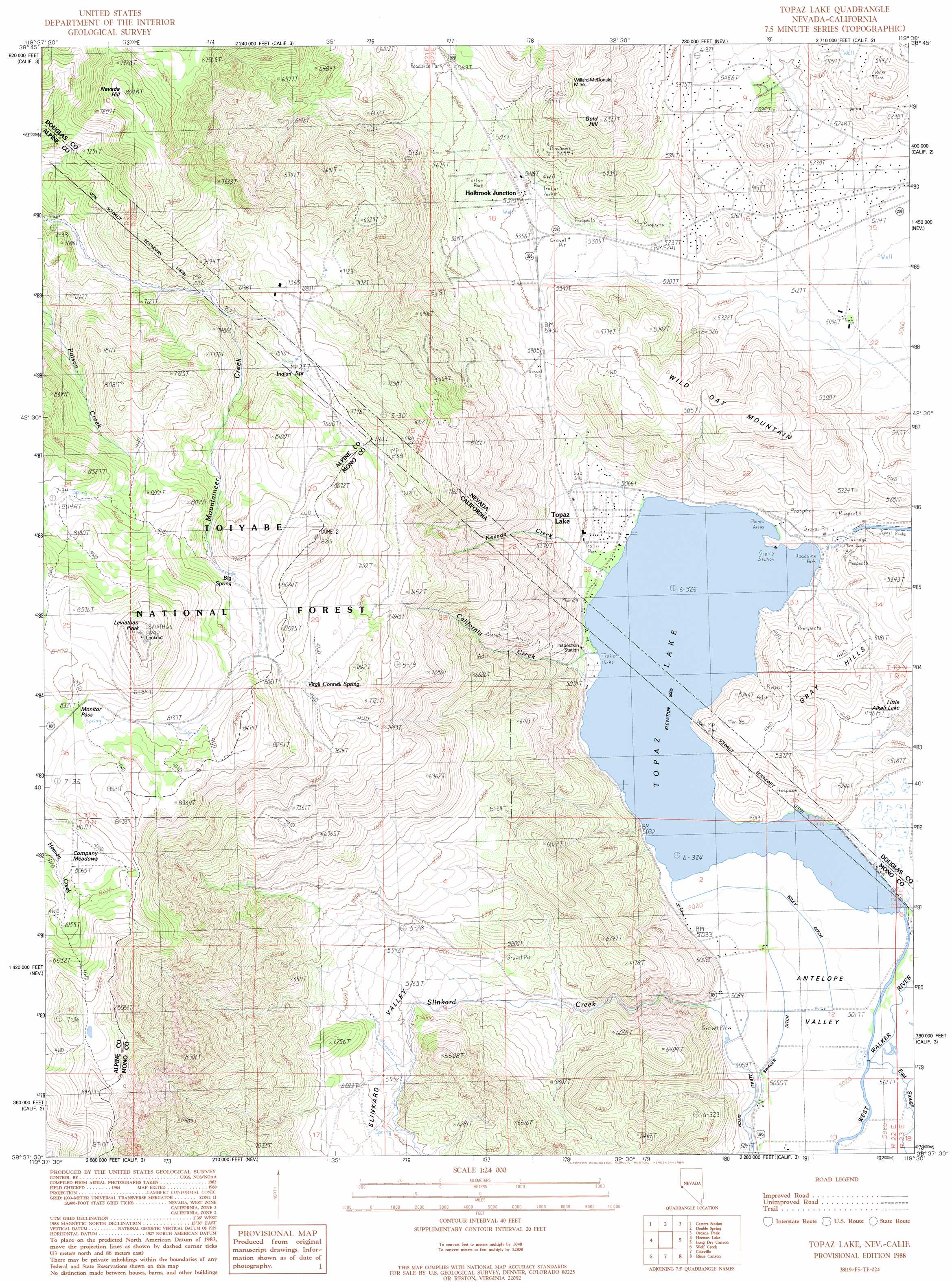
Topaz Lake Topo Map California
To zoom in, hover over the map of Topaz Lake
USGS Topo Quad 38119f5 - 1:24,000 scale
| Topo Map Name: | Topaz Lake |
| USGS Topo Quad ID: | 38119f5 |
| Print Size: | ca. 21 1/4" wide x 27" high |
| Southeast Coordinates: | 38.625° N latitude / 119.5° W longitude |
| Map Center Coordinates: | 38.6875° N latitude / 119.5625° W longitude |
| U.S. States: | CA, NV |
| Filename: | o38119f5.jpg |
| Download Map JPG Image: | Topaz Lake topo map 1:24,000 scale |
| Map Type: | Topographic |
| Topo Series: | 7.5´ |
| Map Scale: | 1:24,000 |
| Source of Map Images: | United States Geological Survey (USGS) |
| Alternate Map Versions: |
Topaz Lake NV 1988, updated 1989 Download PDF Buy paper map Topaz Lake NV 1988, updated 1989 Download PDF Buy paper map Topaz Lake NV 2012 Download PDF Buy paper map Topaz Lake NV 2014 Download PDF Buy paper map |
| FStopo: | US Forest Service topo Topaz Lake is available: Download FStopo PDF Download FStopo TIF |
1:24,000 Topo Quads surrounding Topaz Lake
Minden |
Gardnerville |
Mount Siegel |
Pine Nut Valley |
Artesia Lake |
Woodfords |
Carters Station |
Double Spring |
Oreana Peak |
Smith |
Markleeville |
Heenan Lake |
Topaz Lake |
Long Dry Canyon |
Desert Creek Ranch |
Ebbetts Pass |
Wolf Creek |
Coleville |
Risue Canyon |
Desert Creek Peak |
Dardanelles Cone |
Disaster Peak |
Lost Cannon Peak |
Chris Flat |
Mount Patterson |
> Back to 38119e1 at 1:100,000 scale
> Back to 38118a1 at 1:250,000 scale
> Back to U.S. Topo Maps home
Topaz Lake topo map: Gazetteer
Topaz Lake: Bridges
Tessues Bridge elevation 1527m 5009′Topaz Lake: Canals
Wiley Ditch elevation 1532m 5026′Topaz Lake: Flats
Company Meadows elevation 2463m 8080′Topaz Lake: Gaps
Monitor Pass elevation 2533m 8310′Topaz Lake: Lakes
Topaz Lake elevation 1527m 5009′Topaz Lake: Mines
Kittle Kral Wells Mine elevation 1620m 5314′Willard-McDonald Mine elevation 1887m 6190′
Topaz Lake: Parks
Topaz Lake Park elevation 1531m 5022′Topaz Lake: Populated Places
Holbrook Junction elevation 1643m 5390′Mountain House (historical) elevation 1706m 5597′
Topaz Lake elevation 1547m 5075′
Topaz Lake: Post Offices
Holbrook Post Office (historical) elevation 1705m 5593′Topaz Lake: Ridges
Wild Oat Mountain elevation 1770m 5807′Topaz Lake: Springs
Big Spring elevation 2386m 7828′Indian Spring elevation 2307m 7568′
Virgil Connell Spring elevation 2353m 7719′
Topaz Lake: Streams
California Creek elevation 1527m 5009′East Slough elevation 1529m 5016′
Nevada Creek elevation 1527m 5009′
Slinkard Creek elevation 1530m 5019′
Slinkard Creek elevation 1561m 5121′
Topaz Lake: Summits
Dome Two elevation 2539m 8330′Gold Hill elevation 1938m 6358′
Gray Hills elevation 1654m 5426′
Leviathan Peak elevation 2733m 8966′
Nevada Hill elevation 2442m 8011′
Topaz Lake: Valleys
Slinkard Valley elevation 1681m 5515′Slinkard Valley elevation 1550m 5085′
Topaz Lake digital topo map on disk
Buy this Topaz Lake topo map showing relief, roads, GPS coordinates and other geographical features, as a high-resolution digital map file on DVD: