Heenan Lake Topo Map California
To zoom in, hover over the map of Heenan Lake
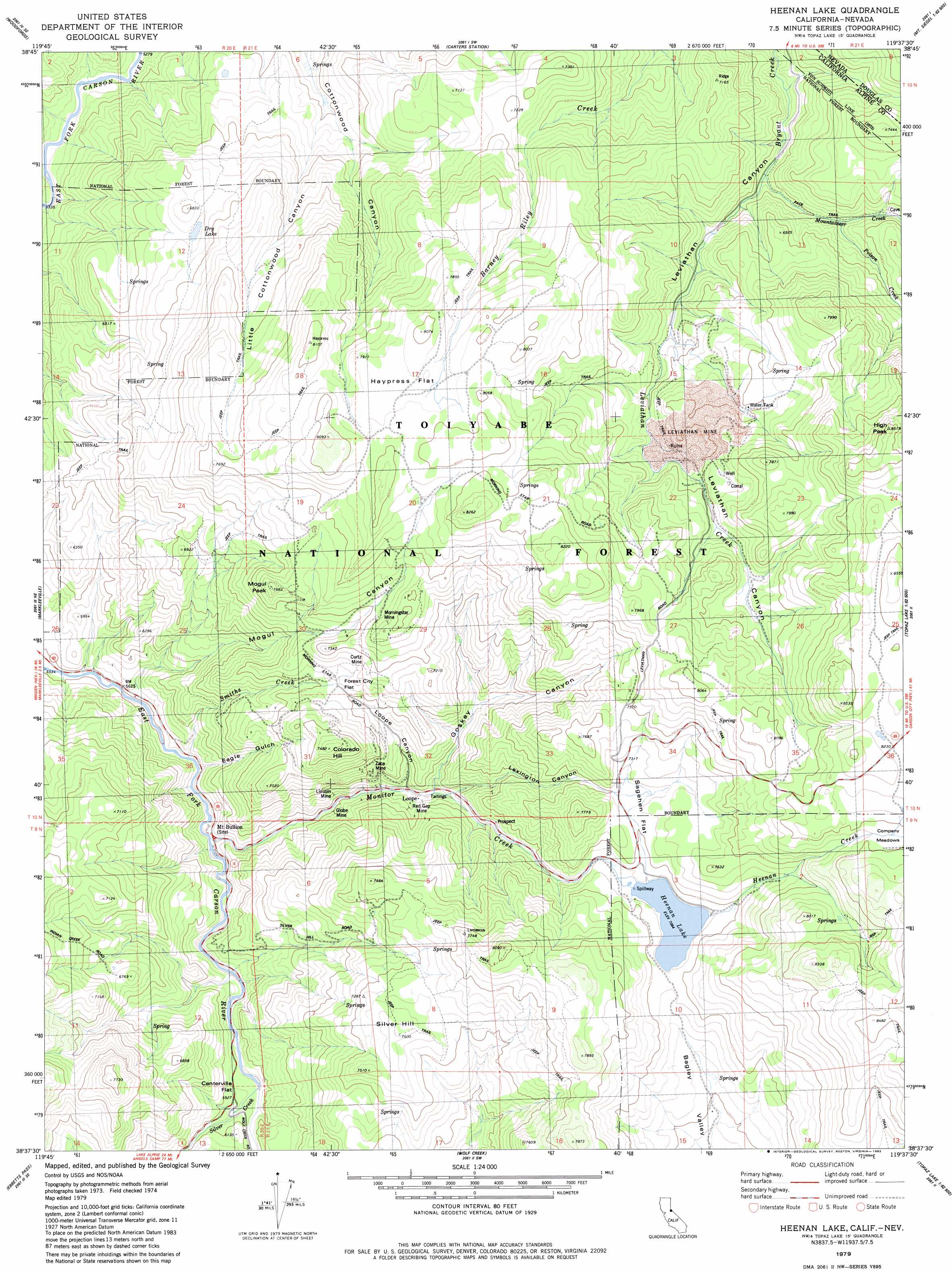
USGS Topo Quad 38119f6 - 1:24,000 scale
| Topo Map Name: | Heenan Lake |
| USGS Topo Quad ID: | 38119f6 |
| Print Size: | ca. 21 1/4" wide x 27" high |
| Southeast Coordinates: | 38.625° N latitude / 119.625° W longitude |
| Map Center Coordinates: | 38.6875° N latitude / 119.6875° W longitude |
| U.S. States: | CA, NV |
| Filename: | o38119f6.jpg |
| Download Map JPG Image: | Heenan Lake topo map 1:24,000 scale |
| Map Type: | Topographic |
| Topo Series: | 7.5´ |
| Map Scale: | 1:24,000 |
| Source of Map Images: | United States Geological Survey (USGS) |
| Alternate Map Versions: |
Heenan Lake CA 1979, updated 1979 Download PDF Buy paper map Heenan Lake CA 1979, updated 1982 Download PDF Buy paper map Heenan Lake CA 1979, updated 1982 Download PDF Buy paper map Heenan Lake CA 2012 Download PDF Buy paper map Heenan Lake CA 2015 Download PDF Buy paper map |
| FStopo: | US Forest Service topo Heenan Lake is available: Download FStopo PDF Download FStopo TIF |
1:24,000 Topo Quads surrounding Heenan Lake
South Lake Tahoe |
Minden |
Gardnerville |
Mount Siegel |
Pine Nut Valley |
Freel Peak |
Woodfords |
Carters Station |
Double Spring |
Oreana Peak |
Carson Pass |
Markleeville |
Heenan Lake |
Topaz Lake |
Long Dry Canyon |
Pacific Valley |
Ebbetts Pass |
Wolf Creek |
Coleville |
Risue Canyon |
Spicer Meadow Res |
Dardanelles Cone |
Disaster Peak |
Lost Cannon Peak |
Chris Flat |
> Back to 38119e1 at 1:100,000 scale
> Back to 38118a1 at 1:250,000 scale
> Back to U.S. Topo Maps home
Heenan Lake topo map: Gazetteer
Heenan Lake: Bridges
Centerville Bridge elevation 1775m 5823′Heenan Lake: Dams
Heenan Lake 514 Dam elevation 2161m 7089′Heenan Lake: Flats
Centerville Flat elevation 1797m 5895′Forest City Flat elevation 2118m 6948′
Haypress Flat elevation 2411m 7910′
Sagehen Flat elevation 2210m 7250′
Heenan Lake: Lakes
Dry Lake elevation 2022m 6633′Heenan Lake: Mines
Curtz Mine elevation 2172m 7125′Globe Mine elevation 1851m 6072′
Leviathan Mine elevation 2262m 7421′
Lincoln Mine elevation 1854m 6082′
Morningstar Mine elevation 2254m 7395′
Red Gap Mine elevation 1915m 6282′
Sunshine Mine elevation 2445m 8021′
Zaca Mine elevation 2007m 6584′
Heenan Lake: Populated Places
Centerville (historical) elevation 1814m 5951′Loope elevation 1886m 6187′
Mount Bullion (historical) elevation 1741m 5711′
Heenan Lake: Reservoirs
Heenan Lake elevation 2161m 7089′Heenan Lake: Streams
Heenan Creek elevation 2167m 7109′Leviathan Creek elevation 1917m 6289′
Monitor Creek elevation 1742m 5715′
Mountaineer Creek elevation 1917m 6289′
Poison Creek elevation 1972m 6469′
Silver Creek elevation 1780m 5839′
Smiths Creek elevation 1726m 5662′
Heenan Lake: Summits
Colorado Hill elevation 2278m 7473′High Peak elevation 2589m 8494′
Mogul Peak elevation 2298m 7539′
Silver Hill elevation 2280m 7480′
Heenan Lake: Trails
Barney Riley Trail elevation 2113m 6932′Heenan Lake: Valleys
Eagle Gulch elevation 1726m 5662′Goskey Canyon elevation 1900m 6233′
Lexington Canyon elevation 1902m 6240′
Little Cottonwood Canyon elevation 1820m 5971′
Loope Canyon elevation 1878m 6161′
Mogul Canyon elevation 1708m 5603′
Heenan Lake digital topo map on disk
Buy this Heenan Lake topo map showing relief, roads, GPS coordinates and other geographical features, as a high-resolution digital map file on DVD: