Wilson Canyon Topo Map Nevada
To zoom in, hover over the map of Wilson Canyon
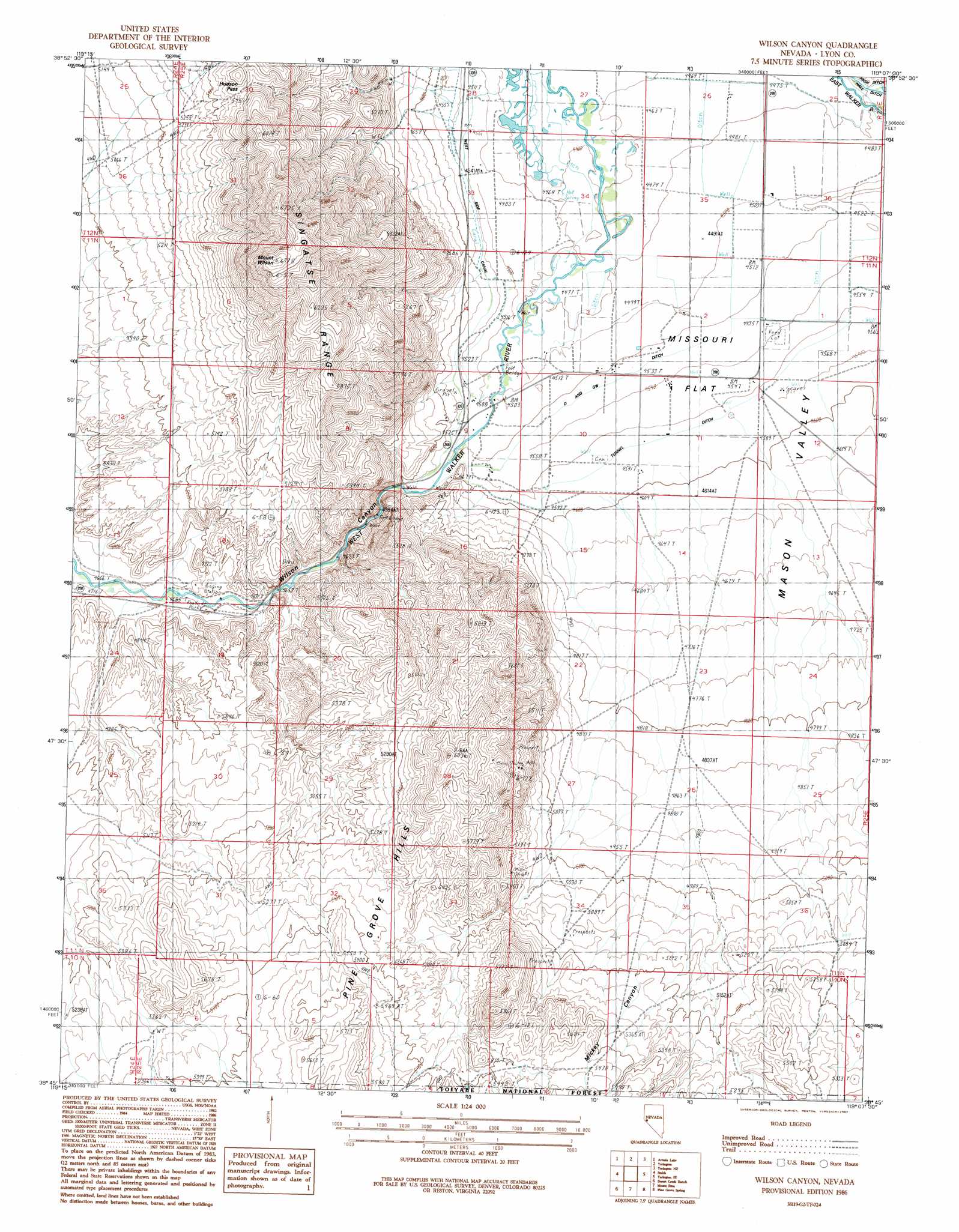
USGS Topo Quad 38119g2 - 1:24,000 scale
| Topo Map Name: | Wilson Canyon |
| USGS Topo Quad ID: | 38119g2 |
| Print Size: | ca. 21 1/4" wide x 27" high |
| Southeast Coordinates: | 38.75° N latitude / 119.125° W longitude |
| Map Center Coordinates: | 38.8125° N latitude / 119.1875° W longitude |
| U.S. State: | NV |
| Filename: | o38119g2.jpg |
| Download Map JPG Image: | Wilson Canyon topo map 1:24,000 scale |
| Map Type: | Topographic |
| Topo Series: | 7.5´ |
| Map Scale: | 1:24,000 |
| Source of Map Images: | United States Geological Survey (USGS) |
| Alternate Map Versions: |
Wilson Canyon NV 1986, updated 1987 Download PDF Buy paper map Wilson Canyon NV 2012 Download PDF Buy paper map Wilson Canyon NV 2014 Download PDF Buy paper map |
| FStopo: | US Forest Service topo Wilson Canyon is available: Download FStopo PDF Download FStopo TIF |
1:24,000 Topo Quads surrounding Wilson Canyon
Mount Como |
Lincoln Flat |
Mason Butte |
Hinkson Slough |
Weber Reservoir |
Pine Nut Valley |
Artesia Lake |
Yerington |
Yerington Ne |
Hussman Spring |
Oreana Peak |
Smith |
Wilson Canyon |
Yerington Se |
Buck Brush Spring |
Long Dry Canyon |
Desert Creek Ranch |
Mount Etna |
Pine Grove Spring |
Butler Mountain |
Risue Canyon |
Desert Creek Peak |
Nye Canyon |
Wichman Canyon |
Mitchell Spring |
> Back to 38119e1 at 1:100,000 scale
> Back to 38118a1 at 1:250,000 scale
> Back to U.S. Topo Maps home
Wilson Canyon topo map: Gazetteer
Wilson Canyon: Canals
D and GW Ditch elevation 1382m 4534′Hillbun Ditch elevation 1365m 4478′
Kelly Alkali Ditch elevation 1366m 4481′
Lee Sanders Ditch elevation 1373m 4504′
Sanders Canal elevation 1376m 4514′
Tunnel Ditch elevation 1392m 4566′
West Side Canal elevation 1380m 4527′
Wilson Canyon: Flats
Missouri Flat elevation 1368m 4488′Wilson Canyon: Gaps
Hudson Pass elevation 1684m 5524′Wilson Canyon: Populated Places
Tippecanoe (historical) elevation 1379m 4524′Wellington Springs elevation 1634m 5360′
Wilson Canyon: Post Offices
Tippecanoe Post Office (historical) elevation 1379m 4524′Wilson Canyon: Springs
Wilson Hot Spring elevation 1596m 5236′Wilson Canyon: Summits
Black Peak elevation 1846m 6056′Mount Wilson elevation 2057m 6748′
Wilson Canyon: Valleys
Mickey Canyon elevation 1585m 5200′Wilson Canyon elevation 1383m 4537′
Wilson Canyon: Wells
Missouri Flat Well elevation 1471m 4826′Wilson Canyon digital topo map on disk
Buy this Wilson Canyon topo map showing relief, roads, GPS coordinates and other geographical features, as a high-resolution digital map file on DVD: