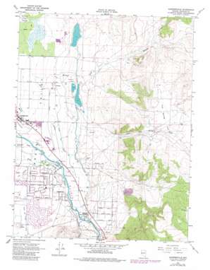
Gardnerville Topo Map Nevada
To zoom in, hover over the map of Gardnerville
USGS Topo Quad 38119h6 - 1:24,000 scale
| Topo Map Name: | Gardnerville |
| USGS Topo Quad ID: | 38119h6 |
| Print Size: | ca. 21 1/4" wide x 27" high |
| Southeast Coordinates: | 38.875° N latitude / 119.625° W longitude |
| Map Center Coordinates: | 38.9375° N latitude / 119.6875° W longitude |
| U.S. State: | NV |
| Filename: | o38119h6.jpg |
| Download Map JPG Image: | Gardnerville topo map 1:24,000 scale |
| Map Type: | Topographic |
| Topo Series: | 7.5´ |
| Map Scale: | 1:24,000 |
| Source of Map Images: | United States Geological Survey (USGS) |
| Alternate Map Versions: |
Gardnerville NV 1969, updated 1971 Download PDF Buy paper map Gardnerville NV 1969, updated 1976 Download PDF Buy paper map Gardnerville NV 1969, updated 1983 Download PDF Buy paper map Gardnerville NV 1974, updated 1977 Download PDF Buy paper map Gardnerville NV 2012 Download PDF Buy paper map Gardnerville NV 2014 Download PDF Buy paper map |
| FStopo: | US Forest Service topo Gardnerville is available: Download FStopo PDF Download FStopo TIF |
1:24,000 Topo Quads surrounding Gardnerville
> Back to 38119e1 at 1:100,000 scale
> Back to 38118a1 at 1:250,000 scale
> Back to U.S. Topo Maps home
Gardnerville topo map: Gazetteer
Gardnerville: Airports
Xebec Industrial Park Heliport elevation 1501m 4924′Gardnerville: Bridges
Allens Bridge (historical) elevation 1485m 4872′Gardnerville: Canals
Allerman Canal elevation 1481m 4858′Edna Wilslef Ditch elevation 1463m 4799′
Lower Old Virginia Canal elevation 1458m 4783′
Old Virginia Canal elevation 1461m 4793′
Upper New Virginia Canal elevation 1469m 4819′
Gardnerville: Dams
Dangberg Dam Number Four elevation 1481m 4858′Dangberg Dam Number Three elevation 1475m 4839′
Gardnerville: Flats
Fish Spring Flat elevation 1570m 5150′Gardnerville: Parks
Lampe Park elevation 1450m 4757′Gardnerville: Populated Places
Buckeye elevation 1465m 4806′Dresslerville elevation 1492m 4895′
Gardnerville elevation 1448m 4750′
Gardnerville Ranchos elevation 1481m 4858′
Twelvemile House elevation 1477m 4845′
Gardnerville: Post Offices
Gardnerville Post Office elevation 1448m 4750′Twelve Mile House Post Office (historical) elevation 1477m 4845′
Gardnerville: Reservoirs
Dangberg Reservoir Number Four elevation 1481m 4858′Dangberg Reservoir Number Three elevation 1475m 4839′
Dresslerville Water Tank (historical) elevation 1492m 4895′
Gardnerville: Springs
Fish Spring elevation 1555m 5101′Gardnerville: Streams
Buckeye Creek elevation 1451m 4760′Indian Creek elevation 1490m 4888′
Pine Nut Creek elevation 1479m 4852′
Gardnerville: Valleys
Williams Canyon elevation 1525m 5003′Gardnerville: Wells
Buckeye Creek Well elevation 1520m 4986′Fish Creek Well elevation 1566m 5137′
Ruhenstroth Well elevation 1679m 5508′
Gardnerville digital topo map on disk
Buy this Gardnerville topo map showing relief, roads, GPS coordinates and other geographical features, as a high-resolution digital map file on DVD:


