Strawberry Topo Map California
To zoom in, hover over the map of Strawberry
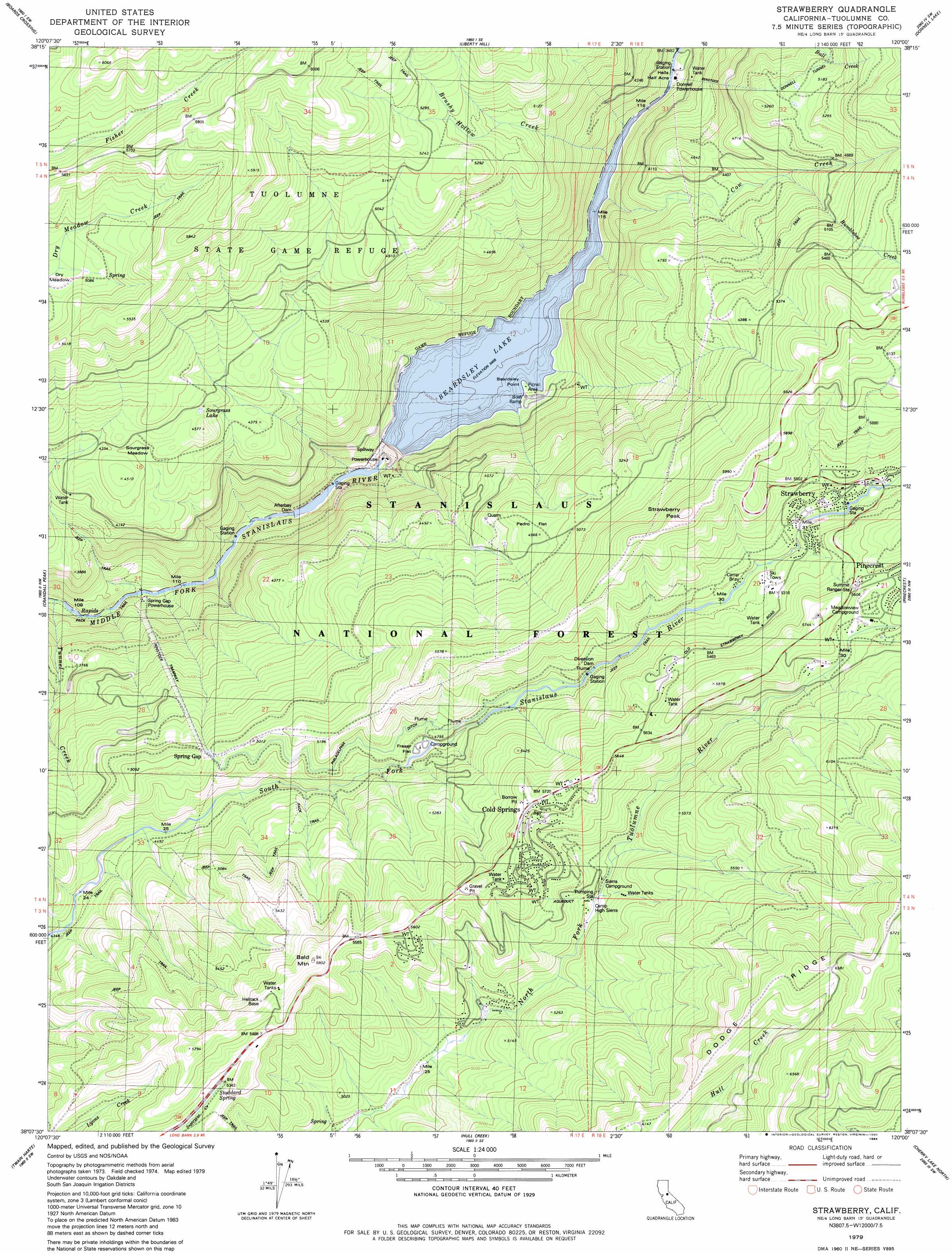
USGS Topo Quad 38120b1 - 1:24,000 scale
| Topo Map Name: | Strawberry |
| USGS Topo Quad ID: | 38120b1 |
| Print Size: | ca. 21 1/4" wide x 27" high |
| Southeast Coordinates: | 38.125° N latitude / 120° W longitude |
| Map Center Coordinates: | 38.1875° N latitude / 120.0625° W longitude |
| U.S. State: | CA |
| Filename: | o38120b1.jpg |
| Download Map JPG Image: | Strawberry topo map 1:24,000 scale |
| Map Type: | Topographic |
| Topo Series: | 7.5´ |
| Map Scale: | 1:24,000 |
| Source of Map Images: | United States Geological Survey (USGS) |
| Alternate Map Versions: |
Strawberry CA 1979, updated 1980 Download PDF Buy paper map Strawberry CA 2001, updated 2004 Download PDF Buy paper map Strawberry CA 2012 Download PDF Buy paper map Strawberry CA 2015 Download PDF Buy paper map |
| FStopo: | US Forest Service topo Strawberry is available: Download FStopo PDF Download FStopo TIF |
1:24,000 Topo Quads surrounding Strawberry
Garnet Hill |
Calaveras Dome |
Tamarack |
Spicer Meadow Res |
Dardanelles Cone |
Dorrington |
Boards Crossing |
Liberty Hill |
Donnell Lake |
Dardanelle |
Stanislaus |
Crandall Peak |
Strawberry |
Pinecrest |
Cooper Peak |
Columbia Se |
Twain Harte |
Hull Creek |
Cherry Lake North |
Kibbie Lake |
Standard |
Tuolumne |
Duckwall Mountain |
Cherry Lake South |
Lake Eleanor |
> Back to 38120a1 at 1:100,000 scale
> Back to 38120a1 at 1:250,000 scale
> Back to U.S. Topo Maps home
Strawberry topo map: Gazetteer
Strawberry: Airports
Bald Mountain Heliport elevation 1720m 5643′Strawberry: Canals
Philadelphia Ditch elevation 1497m 4911′Strawberry: Capes
Beardsley Point elevation 1039m 3408′Strawberry: Dams
Afterbay Dam elevation 959m 3146′Beardsley Dam elevation 1038m 3405′
Strawberry: Flats
Dry Meadow elevation 1546m 5072′Fraser Flat elevation 1461m 4793′
Hells Half Acre elevation 1048m 3438′
Pedro Flat elevation 1508m 4947′
Sourgrass Meadow elevation 1338m 4389′
Strawberry: Lakes
Sourgrass Lake elevation 1366m 4481′Strawberry: Populated Places
Cold Springs elevation 1728m 5669′Spring Gap elevation 1495m 4904′
Strawberry elevation 1623m 5324′
Strawberry: Reservoirs
Beardsley Lake elevation 1038m 3405′Strawberry: Ridges
Dodge Ridge elevation 1968m 6456′Strawberry: Springs
Stoddard Spring elevation 1630m 5347′Strawberry: Streams
Brushy Hollow Creek elevation 1039m 3408′Bumblebee Creek elevation 1389m 4557′
Chinaman Creek elevation 963m 3159′
Cow Creek elevation 1064m 3490′
Leland Creek elevation 1669m 5475′
Strawberry: Summits
Bald Mountain elevation 1771m 5810′Strawberry Peak elevation 1840m 6036′
Strawberry digital topo map on disk
Buy this Strawberry topo map showing relief, roads, GPS coordinates and other geographical features, as a high-resolution digital map file on DVD: